Economy & resources · Atlas of Telangana
Coal belts & Singareni mines of Telangana
Singareni belts and the Gondwana measures
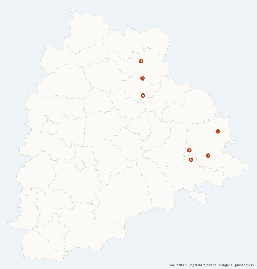
Numbered as on the map
The 7 on the map
1. Bellampalli belt
Mancherial
Known forThe northern end of the Singareni chain.
The northernmost of the Singareni areas, on the Godavari’s north-western reach where the Gondwana measures first come to the surface. It is the oldest worked ground after Yellandu and the belt where underground mining still outweighs opencast.
SettingGodavari valley · Gondwana coal measures · Teak forest fringe
2. Kothagudem belt
Bhadradri Kothagudem
Known forSingareni’s headquarters, and the power station beside it.
The administrative centre of the whole coalfield as well as a belt in its own right: Singareni is run from here, the Kothagudem thermal station at Palwancha is next door, and the Kinnerasani reservoir a few kilometres north was built to cool it. It is the one place in the state where the mining company, the power station and the water that serves both are in sight of each other.
SettingEastern plateau · Gondwana coal measures · Kinnerasani catchment
For the examThe Singareni Collieries Company is headquartered at Kothagudem, not at Ramagundam — a common mix-up, because Ramagundam is the larger industrial complex.
3. Manuguru belt
Bhadradri Kothagudem
Known forThe far eastern belt, and the heavy water plant it feeds.
The easternmost and the most isolated of the belts, on the Godavari in the forest above Bhadrachalam. It supplies the heavy water plant beside it, which is the one piece of national strategic industry the coalfield carries and the reason a small mining town this far out has a railway.
SettingLower Godavari · Gondwana coal measures · Moist deciduous forest
4. Ramagundam belt
Peddapalli
Known forCoal, thermal power and the Godavari within a few kilometres.
The belt that made Telangana a power state. Coal is dug at Godavarikhani, burned at Ramagundam a few kilometres away, and cooled with Godavari water taken from the barrage beside it — the textbook pithead station, with the resource, the water and the load all inside one district.
SettingGodavari valley · Gondwana coal measures · Industrial river town
For the examThe standard Indian example of a pithead thermal station. The coal is Singareni’s, the water is the Godavari’s at Sripada Yellampalli, and the two are within ten kilometres of the boilers.
5. Singareni village
Khammam
Known forWhere the coal was first found, and where the company’s name comes from.
Coal was found here in 1871, the company took the village’s name, and then the mining moved on. Nothing of consequence is dug at Singareni today — the belts that matter are in the next district — so the village is on this layer purely because it explains the name, which is exactly the kind of thing a paper asks.
SettingMunneru catchment · Plateau farmland · Historic prospect
For the examSingareni village is in Khammam district; every working Singareni belt is in Bhadradri Kothagudem, Peddapalli or Mancherial. The company is named after a place it does not mine.
6. Srirampur belt
Peddapalli
Known forThe middle of the Singareni chain, shipping rather than burning.
Between Bellampalli and Ramagundam, and the belt that shows what the coalfield looks like away from the power stations: mining towns strung along a seam with no industry attached to them, shipping coal out by rail rather than burning it where it is dug.
SettingGodavari valley · Gondwana coal measures
7. Yellandu belt
Bhadradri Kothagudem
Known forWhere Singareni’s mining actually began, in the 1880s.
The oldest working in the field. Mining began here in the 1880s, which is why the company’s first railway was laid to Yellandu and why the town is older than every other place on this layer. It sits away from the Godavari, on the plateau between the river and the Munneru.
SettingEastern plateau · Gondwana coal measures · Dry deciduous forest
Keep going