Start hereAbout 1 min
Chapter Overview Map
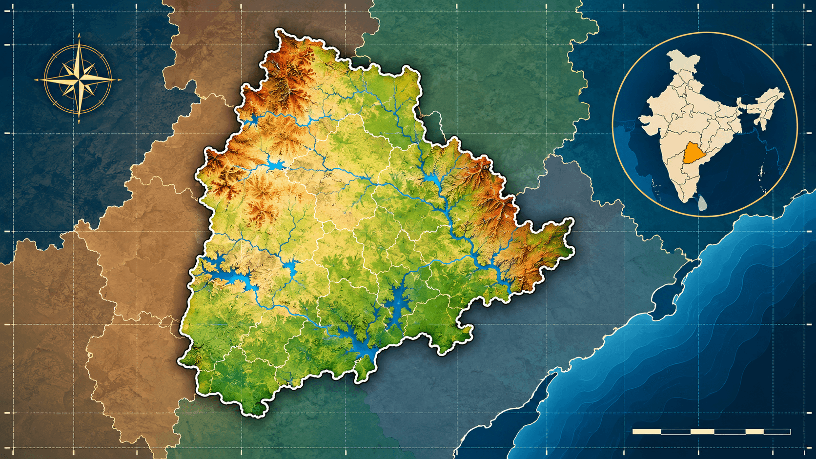
- Telangana lies in the south-central part of peninsular India, on the Deccan Plateau.
- It is landlocked: it has no coastline, and the Bay of Bengal lies beyond Andhra Pradesh.
- Hyderabad is the State capital.
- Hyderabad State, the Nizam's princely State, covered about 82,698 square miles in 1941.
- It was divided on 1 November 1956; its Telugu-speaking districts joined Andhra to form Andhra Pradesh.
- The State of Telangana was formed on 2 June 2014.
- The State covers 1,12,077 sq km between 15°50′–19°55′ N and 77°14′–81°19′ E.
- Four States border it: Maharashtra, Chhattisgarh, Andhra Pradesh and Karnataka.
- Telangana has had 33 districts since 17 February 2019.
- Districts are divided into revenue divisions, and these into revenue mandals.
1.7–1.9 Physical setting and significance
- The State is a plateau of ancient hard rocks, drained by the Godavari and the Krishna.
- Its central Deccan position and the Hyderabad metropolis shape its transport, settlement and economy.
Don't confuse
- Hyderabad State was a much larger historical State; present Telangana is roughly half its area.
- Hyderabad district is a small revenue district; the Hyderabad metropolitan region is far larger.
Notice that the branches follow the chapter's questions: where Telangana is, what it was part of, what it covers, how it is organised and what kind of land it is.
1.1Section 1 of 10About 2 min
Telangana — Location and Geographical Identity
Locating a State means placing it inside larger and larger frames, from the country down to the region. Read the frames below from the largest to the smallest.
Read top to bottom: each frame sits inside the one above it.
- Telangana is a State in the south-central part of peninsular India.
- It lies on the Deccan Plateau, the broad southern part of the Peninsular Plateau (Section 1.7).
- Its capital is Hyderabad, which lies in the south-western half of the State.
- Telangana came into being on 2 June 2014, when the Andhra Pradesh Reorganisation Act, 2014 divided the earlier State of Andhra Pradesh.
- The State is landlocked: it has no coastline, and its nearest sea, the Bay of Bengal, lies to the east beyond Andhra Pradesh.
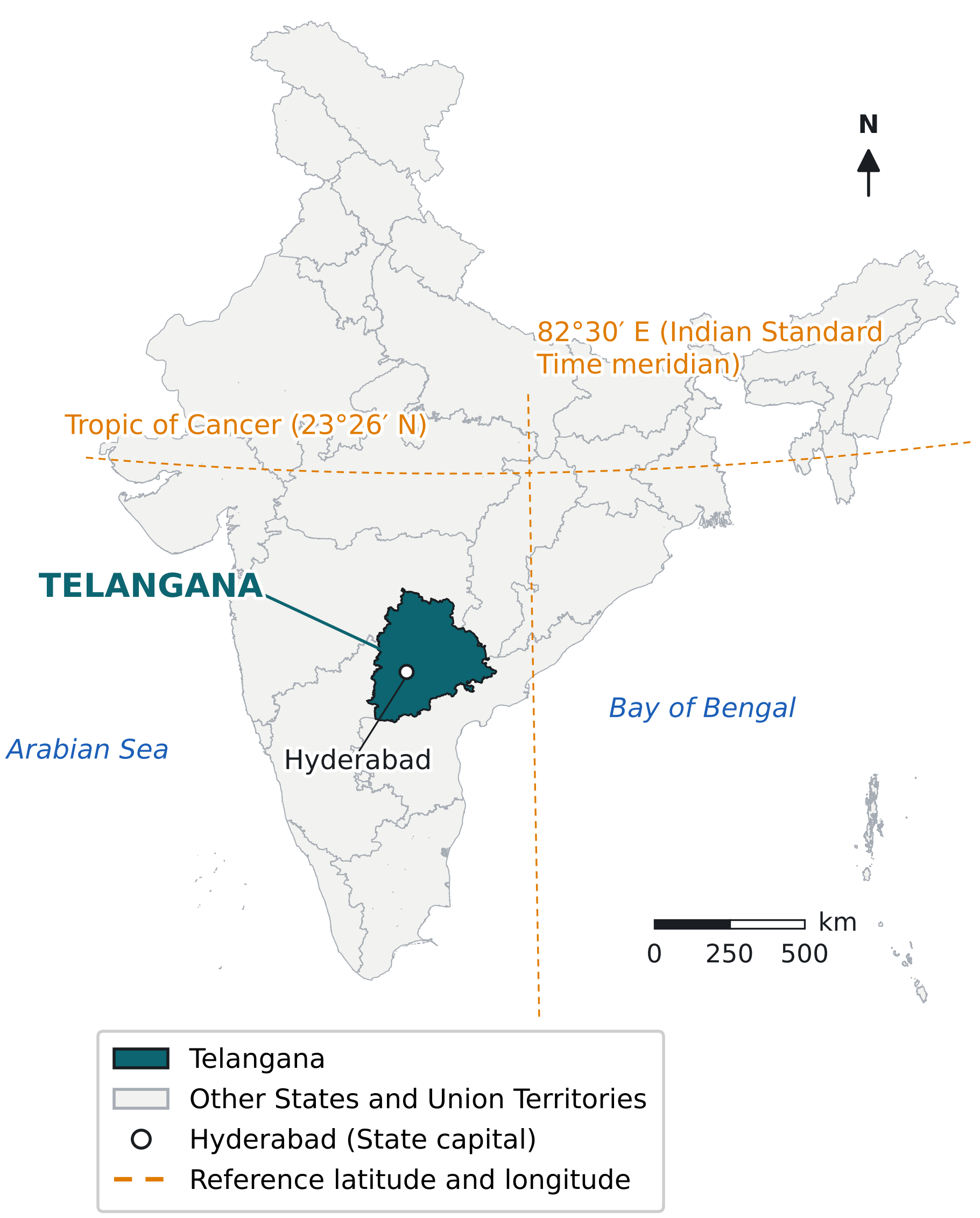
Notice that Telangana lies wholly south of the Tropic of Cancer and wholly west of the 82°30′ E meridian, and that it does not touch the sea.
Source: Survey of India State boundaries, compiled by the Datameet community (indianopenmaps); Lambert conformal projection. Reference year of boundaries: current (post-2014) State map.
- Telangana lies wholly south of the Tropic of Cancer (23°26′ N), so the whole State is in the tropical latitudes.
- It lies wholly west of 82°30′ E, the meridian used for Indian Standard Time (IST), so local sun time in Telangana runs slightly behind IST.
- Four States surround Telangana (details in Section 1.5):
- Maharashtra to the north and north-west.
- Chhattisgarh to the north-east.
- Andhra Pradesh to the east, south-east and south.
- Karnataka to the west and south-west.
1.2Section 2 of 10About 3 min
Geographical Extent of Hyderabad State
- Hyderabad State was a princely State ruled by the Nizams; official records also called it the Nizam's Dominions.
- It covered much of the central Deccan, across the upper Godavari, Manjira, Bhima and Krishna valleys.
- Its capital was the city of Hyderabad, which is also the capital of present Telangana.
Area and Location
- The State reached farther west than present Telangana, into the upper Godavari and Bhima valleys now in Maharashtra and Karnataka.
- In 1951 it had a population of 1,86,55,108 and 16 districts (Census of India 1951).
Three Language Regions
Hyderabad State was not one language region. Its districts fell into three groups, which decided how the State was divided in 1956.
| Region | Main language | Districts in 1951 |
|---|---|---|
| Telangana | Telugu | Hyderabad, Mahbubnagar, Nalgonda, Medak, Nizamabad, Karimnagar, Warangal, Adilabad (8) |
| Marathwada | Marathi | Aurangabad, Parbhani, Nanded, Bhir (now Beed), Osmanabad (5) |
| Kannada districts | Kannada | Gulbarga, Raichur, Bidar (3) |
Notice that the eight Telugu districts formed one compact block in the east. Bidar, Adilabad, Gulbarga, Raichur and Nanded were mixed, so they were split between States in 1956 (Table 1.3).
Source: District list: Census of India 1951, Vol. IX (Hyderabad). Grouping follows the allocation in the States Reorganisation Act, 1956; the Census itself used North and South Hyderabad Divisions.
- Khammam district did not yet exist in 1951: it was formed on 1 October 1953 from five taluks of Warangal district.
- In 1941 the State had four divisions (subahs), Medak, Warangal, Aurangabad and Gulbarga, and 17 districts, including Atraf-i-Balda, the district around Hyderabad city.
- Around 1909–1941 its neighbours were Berar and the Central Provinces to the north and north-east, the Bombay Presidency to the west, and the Madras Presidency to the south and east.
Hyderabad State and Present Telangana Compared
| Feature | Hyderabad State | Present Telangana State |
|---|---|---|
| Status | Princely State until 1948; Part B State of India 1950–1956 | State of India since 2 June 2014 |
| Area | 82,698 sq miles (about 2,14,190 sq km), 1941 | 1,12,077 sq km |
| Latitude | 15°10′–20°40′ N (1909) | 15°50′–19°55′ N |
| Longitude | 74°40′–81°35′ E (1909) | 77°14′–81°19′ E |
| Language regions | Telugu, Marathi and Kannada districts | Mainly the Telugu districts of the old State |
| Capital | Hyderabad | Hyderabad |
Notice that present Telangana is roughly half the area of Hyderabad State and lies in its eastern part; the old State extended much farther west.
Source: Imperial Gazetteer of India (1909); Census of India 1941, Hyderabad State; Telangana Socio Economic Outlook 2024; Government of Telangana, State Profile.
1.3Section 3 of 10About 4 min
From Hyderabad State to Present Telangana
Only the changes that moved boundaries or created a new territorial unit are listed. Each entry says how the geographical unit changed.
- 13–17 Sep 1948Police action (Operation Polo) ends the Nizam's rule; Hyderabad State joins the Indian Union with its territory unchanged
- 26 Jan 1950Hyderabad becomes a Part B State under the Constitution of India, still with the same boundaries
- 1 Oct 1953Khammam district is formed from five Warangal taluks; the new Andhra State (from Madras) becomes a neighbour
- 1 Nov 1956States Reorganisation Act, 1956: Hyderabad State is divided; its Telugu areas join Andhra, which is renamed Andhra Pradesh
- 1959The Bhadrachalam revenue division is moved from East Godavari district to Khammam district
- 1 Mar 2014The Andhra Pradesh Reorganisation Act, 2014 receives assent; it defines Telangana as ten districts of Andhra Pradesh
- 29 May 2014An ordinance, later Act 19 of 2014, keeps seven Khammam mandals, wholly or partly, with Andhra Pradesh
- 2 Jun 2014Telangana State is formed with 10 districts
- 11 Oct 2016District reorganisation: 21 new districts, raising the total to 31
- 17 Feb 2019Mulugu and Narayanpet districts are formed: 33 districts, the present structure
Read top to bottom: oldest to newest. Only territorial and administrative changes are listed.
How Hyderabad State Was Divided in 1956
| Received by | Territory of Hyderabad State | Where it lies today |
|---|---|---|
| Andhra, renamed Andhra Pradesh | Eight whole districts: Hyderabad, Medak, Nizamabad, Karimnagar, Warangal, Khammam, Nalgonda, Mahbubnagar | Telangana, except seven Khammam mandals moved to Andhra Pradesh in 2014 |
| Adilabad district, except the Islapur circle and the Kinwat and Rajura taluks | Telangana | |
| Parts of other districts: Alampur and Gadwal (Raichur), Kodangal and Tandur (Gulbarga), Zahirabad and Narayankhed (Bidar), five circles of Nanded | Telangana | |
| Bombay | Aurangabad, Parbhani, Bhir and Osmanabad districts; Nanded district except five circles | Maharashtra (Marathwada) |
| Ahmadpur, Nilanga and Udgir taluks of Bidar; Islapur circle and Kinwat and Rajura taluks of Adilabad | Maharashtra | |
| Mysore | Gulbarga, Raichur and Bidar districts, except the parts listed above | Karnataka |
Notice that district lines were not always followed: mixed districts such as Bidar, Adilabad and Nanded were split by taluk or circle.
Source: States Reorganisation Act, 1956 (Act 37 of 1956), sections 3, 7 and 8; appointed day 1 November 1956.
- The appointed day of the Act was 1 November 1956; on that day Hyderabad State ceased to exist.
- The Telangana areas then formed the Telangana region of Andhra Pradesh until 2014.
Boundary Changes Around 2014
- The Andhra Pradesh Reorganisation Act, 2014 (Act 6 of 2014) formed Telangana from the Adilabad, Karimnagar, Medak, Nizamabad, Warangal, Ranga Reddy, Nalgonda, Mahbubnagar, Khammam and Hyderabad districts.
- Before 1959 the whole Bhadrachalam revenue division belonged to East Godavari district; it was then moved to Khammam district for administrative reasons.
- An amendment (ordinance of 29 May 2014, replaced by Act 19 of 2014) left seven mandals of Khammam district in Andhra Pradesh:
- Five whole mandals: Kukunoor, Velairpadu, Chintoor, Kunavaram and Vararamachandrapuram.
- Two mandals in part: Bhurgampadu and Bhadrachalam; twelve Bhurgampadu villages and the Bhadrachalam revenue village stayed in Telangana.
- The stated purpose was to ease the rehabilitation and resettlement work of the Polavaram irrigation project on the Godavari.
1.4Section 4 of 10About 3 min
Geographical Extent of Present Telangana State
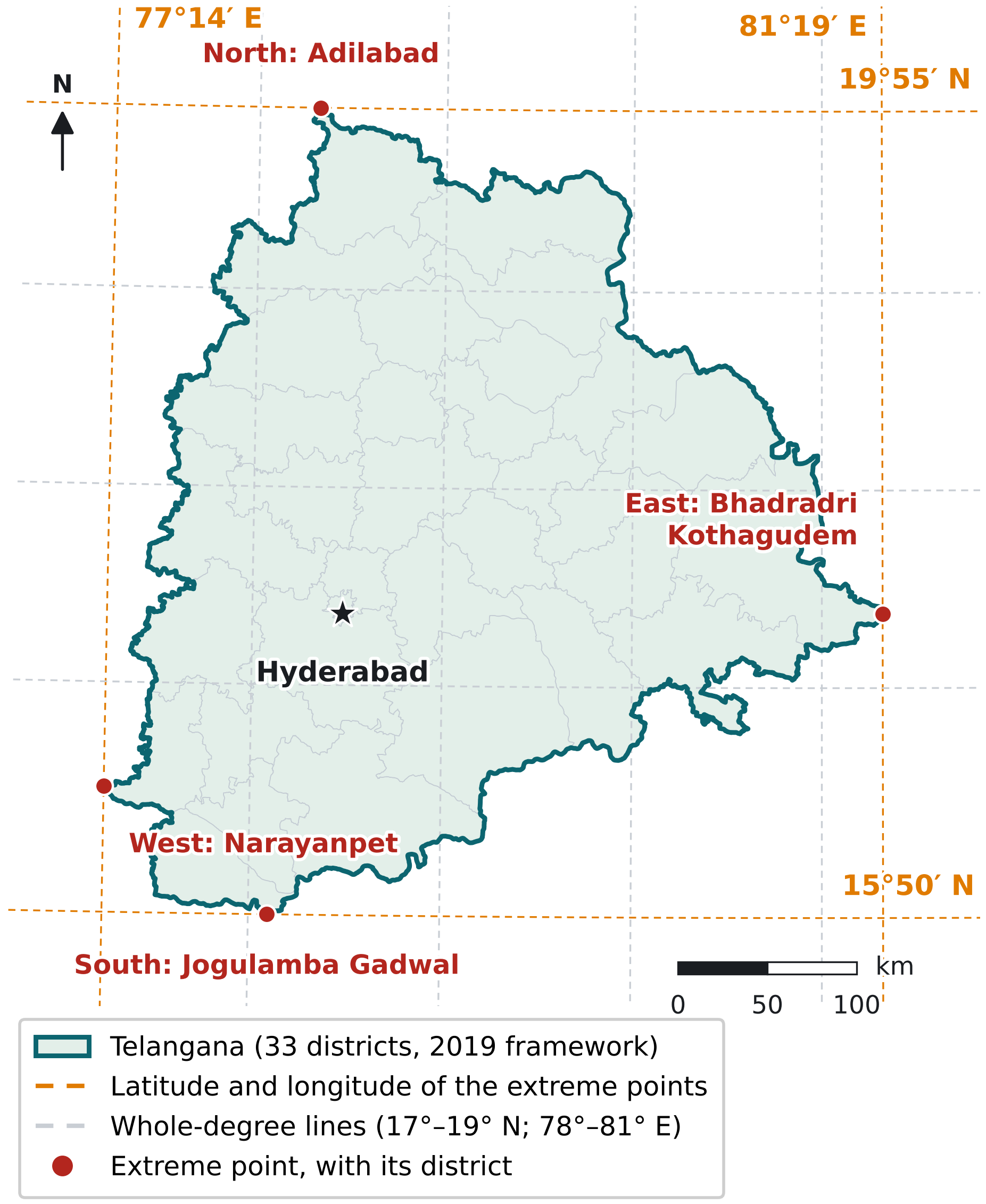
Notice that the State spans a little over 4° of latitude and a little over 4° of longitude, and that each extreme point lies in a different border district.
Source: Extent lines: Telangana Socio Economic Outlook 2024. Extreme points and their districts computed from the Survey of India State boundary and Local Government Directory districts (2019 framework), UTM zone 44N. Boundary status: current State boundary.
Latitude, Longitude and Shape
- The State spans about 4°05′ of latitude (15°50′ to 19°55′ N) and about 4°05′ of longitude (77°14′ to 81°19′ E).
- The northernmost point is in Adilabad district and the southernmost in Jogulamba Gadwal district.
- The easternmost point is in Bhadradri Kothagudem district and the westernmost in Narayanpet district.
- The State is compact: roughly as wide from east to west as it is long from north to south, with a bulge to the east in Khammam and Bhadradri Kothagudem districts.
Area: One Figure, Several Versions
- The current official area is 1,12,077 sq km, used by the Government of Telangana's State Profile and the Socio Economic Outlook 2024.
- Some earlier official publications printed other figures, for example 1,14,840 sq km in the Socio Economic Outlook 2015.
- An area measured from the Survey of India boundary in an equal-area projection comes to about 1,12,100 sq km, which agrees with the current figure.
A Landlocked State
- A landlocked region has no coastline; Telangana's nearest coast is in Andhra Pradesh.
- Telangana's sea trade therefore has to pass through ports in neighbouring coastal States.
- Its rivers, the Godavari and Krishna, flow out of the State into Andhra Pradesh before reaching the Bay of Bengal.
1.5Section 5 of 10About 3 min
Boundaries and Neighbouring States
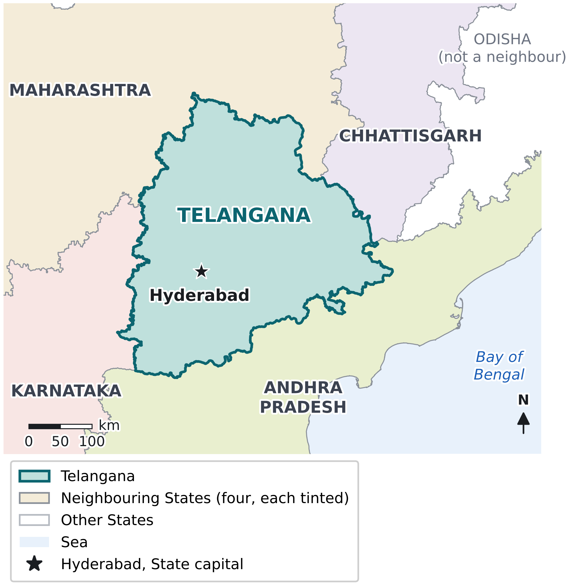
Notice that Andhra Pradesh wraps round Telangana's east and south, while Odisha lies close to the north-east but does not touch it.
Source: Boundaries: Survey of India State boundaries and Local Government Directory districts (2019 framework), compiled by the Datameet community (indianopenmaps). Reference year: current State boundaries. Boundary status: State boundaries as published by the Survey of India.
| Neighbouring State | Direction from Telangana | Telangana districts along the border | Rivers along parts of the border |
|---|---|---|---|
| Maharashtra | North and north-west | Adilabad, Kumuram Bheem Asifabad, Nirmal, Kamareddy, Nizamabad, Mancherial, Jayashankar Bhupalapally | Penganga, Wardha, Pranhita, Godavari |
| Chhattisgarh | North-east | Bhadradri Kothagudem, Mulugu, Jayashankar Bhupalapally | A short stretch of the Godavari |
| Andhra Pradesh | East, south-east and south | Khammam, Bhadradri Kothagudem, Nagarkurnool, Jogulamba Gadwal, Suryapet, Nalgonda, Wanaparthy | Krishna, Tungabhadra and a short stretch of the Godavari |
| Karnataka | West and south-west | Sangareddy, Narayanpet, Vikarabad, Jogulamba Gadwal, Kamareddy | A short stretch of the Krishna; mostly a land boundary |
Notice that rivers form only parts of the boundary; most of the boundary with Karnataka and Chhattisgarh crosses open land.
Source: Computed by overlaying Local Government Directory districts (2019 framework) and India-WRIS river lines on the Survey of India State boundary; districts listed in order of border length. Reference date: current boundaries.
- The boundary with Andhra Pradesh is the longest, about 930 km, followed by Maharashtra (about 820 km), Karnataka (about 560 km) and Chhattisgarh (about 210 km).
- Jogulamba Gadwal borders both Karnataka and Andhra Pradesh, and Kamareddy borders both Maharashtra and Karnataka.
- In the north-east, Jayashankar Bhupalapally and Bhadradri Kothagudem each touch two neighbouring States.
- Odisha is not a neighbour: at its closest it lies about 30 km beyond Telangana's north-eastern tip.
1.6Section 6 of 10About 5 min
Administrative Geography of Telangana
For administration, the State is divided into districts, each district into revenue divisions, and each division into revenue mandals.
| Unit | What it is | Number in Telangana |
|---|---|---|
| State | The whole territory under the State Government at Hyderabad | 1 |
| District | The main administrative unit, headed by a District Collector | 33 (since 17 February 2019) |
| Revenue division | A part of a district, headed by a Revenue Divisional Officer | 74 |
| Revenue mandal | A group of revenue villages, headed by a Tahsildar; the basic unit for revenue and local data | 612 |
| Revenue village | The smallest revenue unit, with recorded land boundaries | 10,434 (Census 2011 basis) |
Notice that each unit fits wholly inside the one above it; a mandal never crosses a district boundary.
Source: Government of Telangana, State Profile (telangana.gov.in), page updated December 2025; Socio Economic Outlook 2024.
From 10 Districts to 33
Read left to right: each step is a reorganisation under the Telangana Districts (Formation) Act, 1974.
- On 11 October 2016, 21 new districts were created; the State Government also created new revenue divisions and mandals at the same time.
- On 17 February 2019, Mulugu was carved out of Jayashankar Bhupalapally and Narayanpet out of Mahabubnagar.
- In 2021, Warangal Urban district was renamed Hanumakonda and Warangal Rural was renamed Warangal; the total stayed 33.
- Districts, divisions and mandals are formed or altered by notification under the Telangana Districts (Formation) Act, 1974.
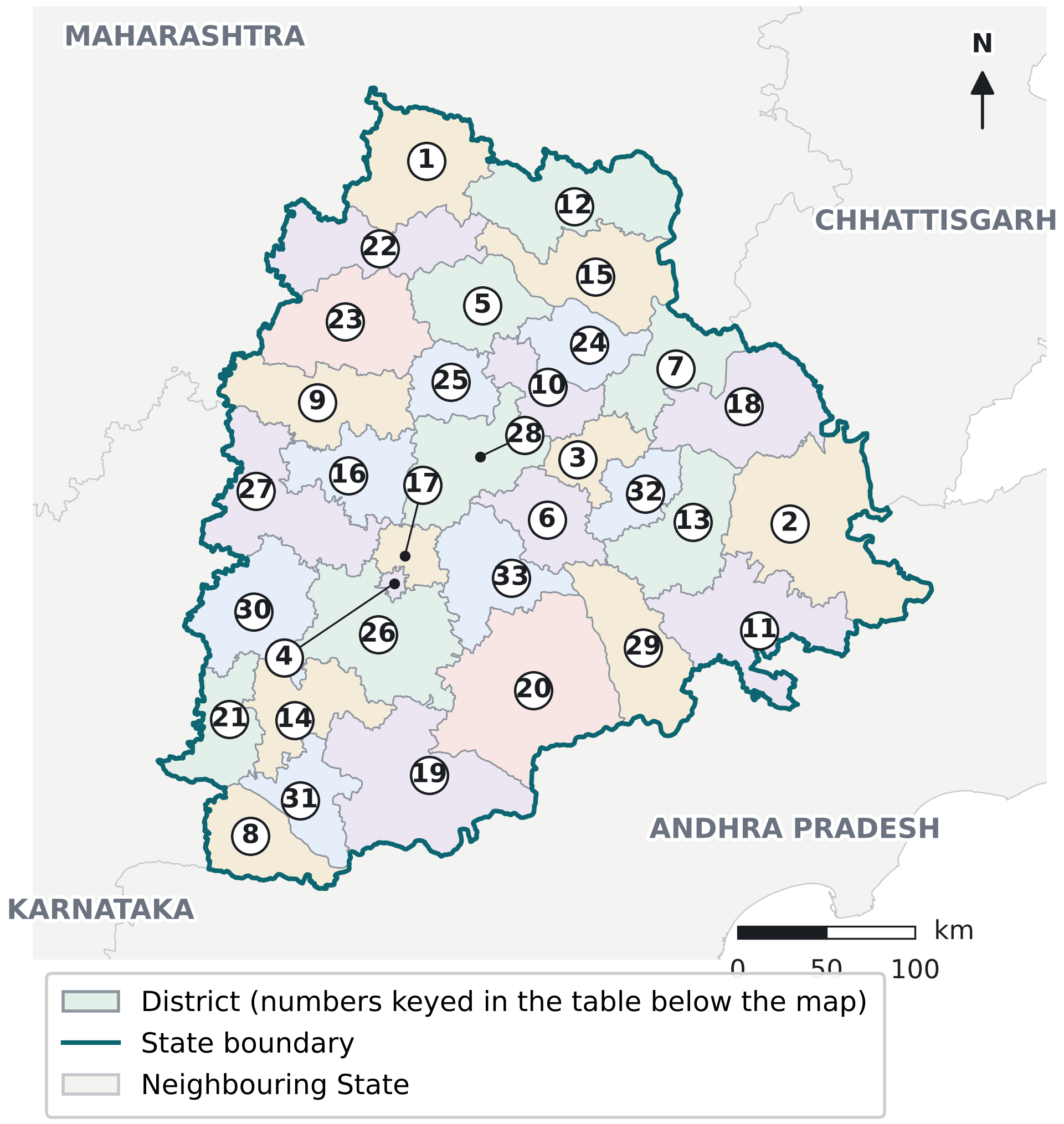
Notice how small Hyderabad district (4) is, and that it is enclosed by Ranga Reddy (26) and Medchal Malkajgiri (17).
Source: Local Government Directory districts, 2019 framework (33 districts), compiled by the Datameet community (indianopenmaps); State boundary: Survey of India. Boundary status: current district boundaries; not valid for years before 17 February 2019.
| No. | District | No. | District | No. | District |
|---|---|---|---|---|---|
| 1 | Adilabad | 12 | Kumuram Bheem Asifabad | 23 | Nizamabad |
| 2 | Bhadradri Kothagudem | 13 | Mahabubabad | 24 | Peddapalli |
| 3 | Hanumakonda | 14 | Mahabubnagar | 25 | Rajanna Sircilla |
| 4 | Hyderabad | 15 | Mancherial | 26 | Ranga Reddy |
| 5 | Jagitial | 16 | Medak | 27 | Sangareddy |
| 6 | Jangoan | 17 | Medchal Malkajgiri | 28 | Siddipet |
| 7 | Jayashankar Bhupalapally | 18 | Mulugu | 29 | Suryapet |
| 8 | Jogulamba Gadwal | 19 | Nagarkurnool | 30 | Vikarabad |
| 9 | Kamareddy | 20 | Nalgonda | 31 | Wanaparthy |
| 10 | Karimnagar | 21 | Narayanpet | 32 | Warangal |
| 11 | Khammam | 22 | Nirmal | 33 | Yadadri Bhuvanagiri |
Read the numbers against Figure 1.7; districts are numbered alphabetically, with names spelt as in the Local Government Directory.
District Boundaries Change: Use Data With Care
| Framework | Period | Number of districts | Typical data |
|---|---|---|---|
| Telangana region of Andhra Pradesh | Up to 2 June 2014 | 10 (from 1978, when Ranga Reddy was formed) | Census 2011 district tables |
| At State formation | 2 June 2014 – 10 October 2016 | 10 | Early State statistics |
| After first reorganisation | 11 October 2016 – 16 February 2019 | 31 | Data for 2016–2018 |
| Present | 17 February 2019 onwards | 33 | Current State data and maps |
Notice that every dataset belongs to one framework; check the year before comparing districts.
Source: Andhra Pradesh Reorganisation Act, 2014; Government of Telangana district notifications of 2016 and 2019; Census of India 2011.
Which Hyderabad
| Area | What it covers | Key fact |
|---|---|---|
| Hyderabad district | The revenue district of the old city and its core | 16 mandals; the smallest district by area |
| Hyderabad municipal corporations | Urban local bodies for the city | Enlarged on 2 December 2025 and divided into three corporations in February 2026 (reported) |
| Hyderabad Metropolitan Development Authority (HMDA) region | The planning region round the city, spread over several districts | About 7,257 sq km at its formation in 2008 |
| Hyderabad urban agglomeration | The continuous built-up city with its outgrowths, as defined by the Census | About 77 lakh people (Census 2011) |
Notice that each wider area contains the narrower ones, so a figure for one cannot stand for another.
Source: Census of India 2011; HMDA Act, 2008; GHMC (Second Amendment) Ordinance, 2025; press reports on the 2026 municipal reorganisation.
1.7Section 7 of 10About 3 min
Telangana in the Deccan Plateau
- The Peninsular Plateau is one of the oldest and most stable landmasses of India, built mainly of very ancient gneisses and granites (NCERT).
- The Deccan Plateau is its large southern part, bordered by the Western Ghats to the west, the Eastern Ghats to the east, and the Satpura, Maikal and Mahadeo hills to the north.
- Telangana lies in the eastern part of the Deccan Plateau, between the Western Ghats and the low, broken Eastern Ghats.
- The plateau's general elevation falls from west to east, which is why its major rivers flow eastward to the Bay of Bengal.
Why Telangana Is a Plateau State
- The Central Ground Water Board states that nearly 80 percent of Telangana is underlain by hard rock formations such as granites and gneisses.
- Geography texts call the part of the Deccan in this area the Telangana Plateau; it is a physical region, not a legal unit, and its edges do not follow the State line.
- Detailed relief, with its hills, plateaus and valleys, is taught in Chapter 2; rocks and minerals come in later chapters.
Telangana in Two River Basins
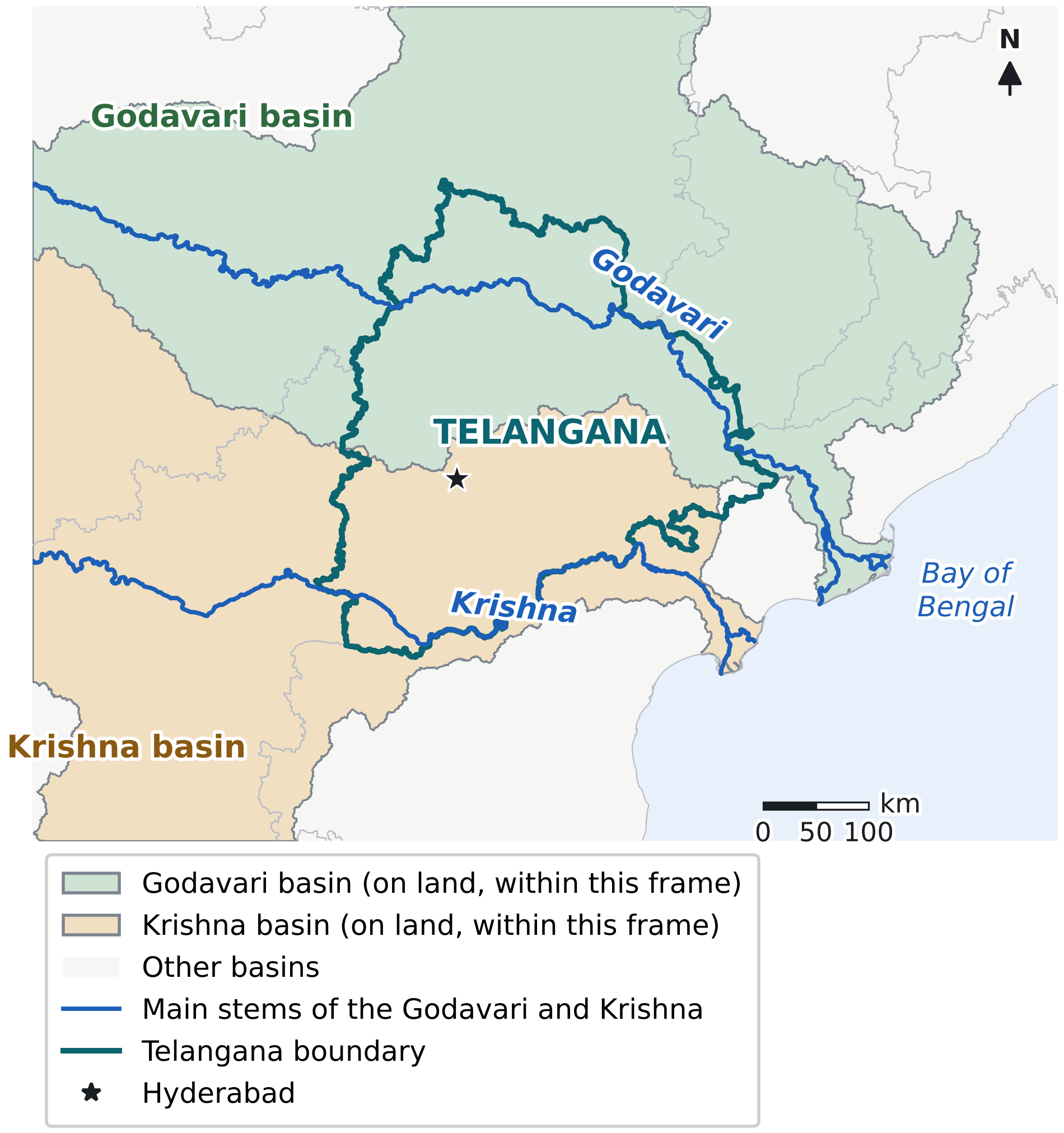
Notice that the basin divide cuts across the State from west to east, a little north of Hyderabad, and that both rivers leave the State before reaching the sea.
Source: Basins and rivers: India-WRIS (Central Water Commission and ISRO); State boundary: Survey of India; compiled by the Datameet community (indianopenmaps). Reference: current State boundary.
- The Godavari basin covers roughly the northern half of the State and the Krishna basin roughly the southern half.
- Both rivers rise far to the west, cross the plateau eastward, and reach the Bay of Bengal through Andhra Pradesh.
- The divide between the two basins follows higher ground, so it does not match any district or State line (Figure 1.8).
1.8Section 8 of 10About 1 min
Broad Physical Setting of Telangana
This section gives only the bird's-eye view. Each element is explained in the chapter shown beside it.
Plateau and uplands
- Most of the State is a rolling plateau of granite and gneiss, with scattered hills and rocky knolls (Chapter 2).
River valleys and basins
- The Godavari valley crosses the north and the Krishna valley the south (Chapter 2).
- Tributaries such as the Manjira, Musi and Pranhita divide the plateau into smaller basins.
Forested tracts
- Large forests lie mainly along the Godavari valley in the north and north-east (Chapter 4).
Dry interior
- Mean rainfall is lowest in the old Mahabubnagar district (about 732 mm) and highest in old Adilabad (about 1,121 mm), according to the Central Ground Water Board (Chapter 3).
Urban core
- The Hyderabad metropolitan region on the Musi forms the State's largest built-up area.
Notice that each branch is only introduced here; the chapter in brackets explains it in detail.
| Physical element | What it shapes |
|---|---|
| Relief | The drainage pattern: where rivers rise and which way they flow |
| Climate | Water availability in rivers, tanks and groundwater |
| Soils | What agriculture is possible and how productive it is |
| Minerals | Where mining-based industry develops |
| Rivers | Where irrigation and settlements concentrate |
| Plateau setting | The layout of transport routes and settlement patterns |
Notice that each row links one physical element to the human geography it influences; later chapters develop each link.
1.9Section 9 of 10About 1 min
Geographical Significance of Telangana
Read top to bottom: the first four factors together produce the last.
| Dimension | Advantage | Constraint |
|---|---|---|
| Central Deccan position | Lies on routes linking northern and southern parts of the peninsula | Far from the coast, so sea trade must pass through other States |
| Plateau terrain | Firm, mostly level ground suits roads, railways and buildings | Thin soils over hard rock in many areas |
| River basins | The Godavari and Krishna provide water for irrigation and towns | Water must be lifted from valleys to the higher plateau |
| Hard-rock geology | Mineral resources such as coal in the Godavari valley | Groundwater is stored mainly in weathered and fractured rock and is limited |
| Hyderabad metropolis | Concentrates services, industry and transport links | Growth is concentrated in one region of the State |
Notice that each feature brings both an advantage and a constraint; neither alone describes the State.
Source: Synthesis of Sections 1.4 to 1.8; details in later chapters.
- National Highway 44 (north to south) and National Highway 65 (west to east) both pass through Hyderabad, linking the State with the rest of India.
- Secunderabad, Hyderabad's twin city, is the headquarters of the South Central Railway zone of Indian Railways.
1.10Section 10 of 10About 2 min
Locate & Recall — Telangana Map Practice
Use the numbered map first without looking at the answers. Then check yourself against the answer table.
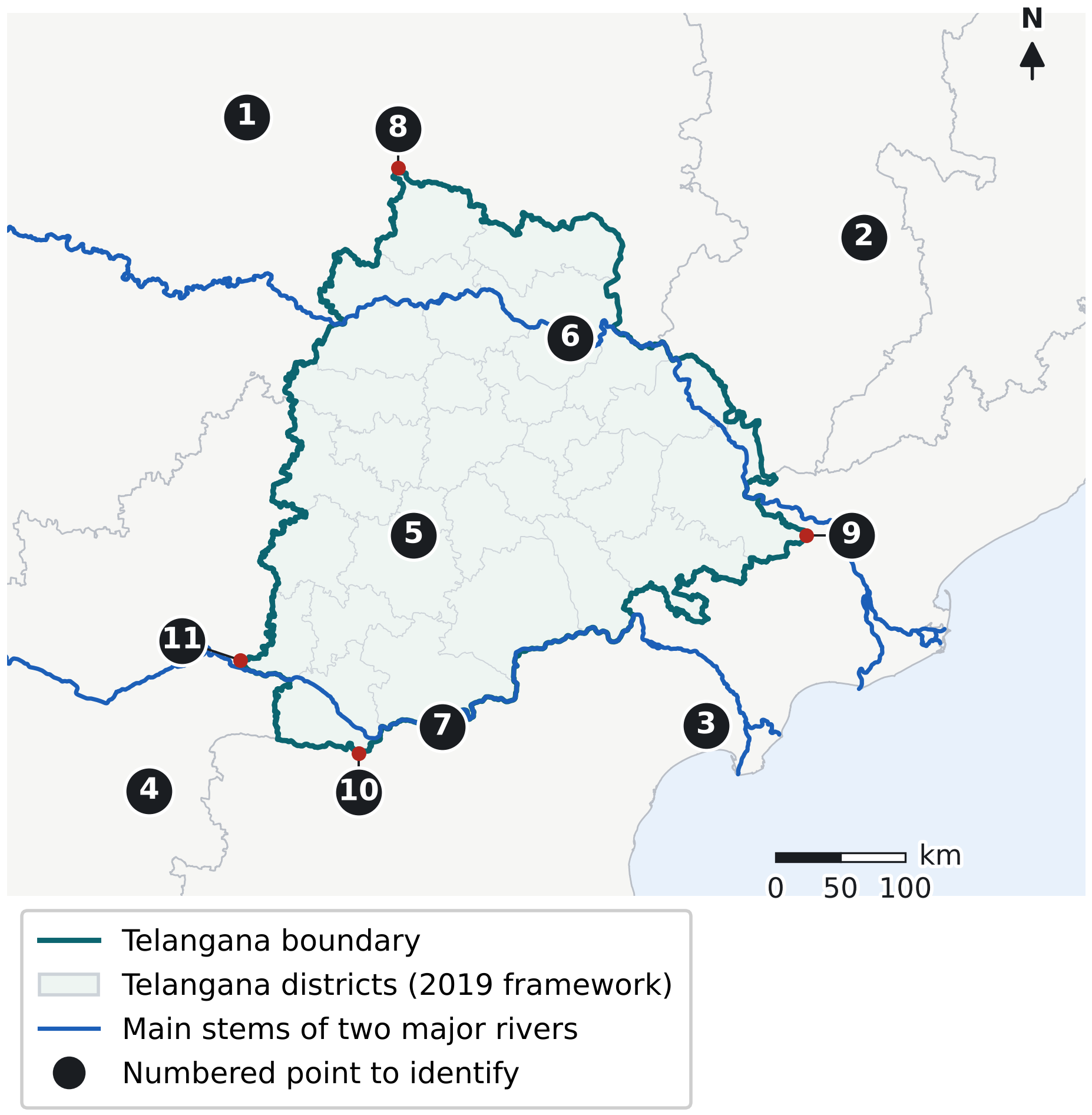
Notice that the four extreme points (8 to 11) sit on the State boundary, each in a different border district.
Source: Boundaries: Survey of India State boundaries and Local Government Directory districts (2019 framework), compiled by the Datameet community (indianopenmaps); rivers: India-WRIS. Reference: current State boundary; districts in the 2019 framework.
A. Basic location
- Name the neighbouring States numbered 1, 2, 3 and 4, and give the direction of each from Telangana.
- Identify point 5, the State capital.
- Using the north arrow, say which side of Telangana faces the Bay of Bengal.
B. Broad physical context
- Name the rivers marked 6 and 7, and say which river basin covers the northern half and which the southern half of the State.
- Shade the area of the Deccan Plateau on the map: does it stop at the State boundary?
C. Administrative orientation
- Name the districts that contain the extreme points 8, 9, 10 and 11.
- On Figure 1.7, find Hyderabad (4), Ranga Reddy (26) and Medchal Malkajgiri (17), and describe their positions relative to each other.
- On Figure 1.7, list the three districts that touch Chhattisgarh.
D. Historical comparison
- Using Table 1.2, compare the latitude and longitude limits of Hyderabad State and present Telangana: in which direction did the old State extend farther?
| No. | Answer | Why it matters |
|---|---|---|
| 1 | Maharashtra | Borders Telangana on the north and north-west |
| 2 | Chhattisgarh | Borders Telangana on the north-east |
| 3 | Andhra Pradesh | Borders Telangana on the east, south-east and south; the longest boundary |
| 4 | Karnataka | Borders Telangana on the west and south-west |
| 5 | Hyderabad | State capital, in the south-western half of the State |
| 6 | Godavari | Main river of the northern half of the State |
| 7 | Krishna | Main river of the southern half; forms part of the border with Andhra Pradesh |
| 8 | Adilabad district | Northernmost point, near 19°55′ N |
| 9 | Bhadradri Kothagudem district | Easternmost point, near 81°19′ E |
| 10 | Jogulamba Gadwal district | Southernmost point, near 15°50′ N |
| 11 | Narayanpet district | Westernmost point, near 77°14′ E |
Other answers: the Bay of Bengal lies to the east; the Deccan Plateau continues beyond the State boundary; Bhadradri Kothagudem, Mulugu and Jayashankar Bhupalapally touch Chhattisgarh; Hyderabad State extended farther west and north.
RevisionAbout 1 min
Memory and Recall Review
| Topic | Memory aid | What to recall |
|---|---|---|
| Neighbouring States | "My Clock Always Knows" (memory block, Section 1.1) | Maharashtra, Chhattisgarh, Andhra Pradesh, Karnataka, clockwise from the north |
| Location frames | Nested flow: India to Telangana (Section 1.1) | India, peninsular India, Deccan Plateau, Telangana |
| Three territories | Don't confuse box (Section 1.2.3) | Hyderabad State, Telangana region, Telangana State |
| Territorial change | Timeline (Section 1.3) | 1948, 1950, 1953, 1956, 1959, 2014, 2016, 2019 |
| Districts | Flow 10 to 31 to 33 (Section 1.6.1) | 2 June 2014, 11 October 2016, 17 February 2019 |
| Extent | Extent map and anchors (Section 1.4) | 15°50′–19°55′ N, 77°14′–81°19′ E; 18° N and 79° E cross the middle |
| Physical setting | Mind map and link table (Section 1.8) | Plateau, valleys, forests, dry interior, urban core; links to Chapters 2–9 |
Revise right after first reading, again the next day, after about a week and after about a month, each time redrawing the neighbours map from memory.
RevisionAbout 1 min
Rapid Revision Sheet
| Item | Fact |
|---|---|
| Location | South-central peninsular India, on the eastern Deccan Plateau; landlocked |
| Capital | Hyderabad, near 17°22′ N, 78°28′ E |
| Formed | 2 June 2014, Andhra Pradesh Reorganisation Act, 2014 (Act 6 of 2014) |
| Area | 1,12,077 sq km; 11th among States |
| Latitude | 15°50′10″ N to 19°55′4″ N |
| Longitude | 77°14′8″ E to 81°19′16″ E |
| Extreme points | North: Adilabad; South: Jogulamba Gadwal; East: Bhadradri Kothagudem; West: Narayanpet |
| Neighbours | Maharashtra (north, north-west), Chhattisgarh (north-east), Andhra Pradesh (east, south-east, south), Karnataka (west, south-west) |
| Longest boundary | With Andhra Pradesh, about 930 km (computed) |
| Hyderabad State | 82,698 sq miles (1941); Telugu, Marathi and Kannada districts; divided 1 November 1956 |
| 2014 boundary change | Seven Khammam mandals, wholly or partly, left with Andhra Pradesh (Act 19 of 2014) |
| Districts | 10 (2014), 31 (11 October 2016), 33 (17 February 2019 to date) |
| Revenue units | 74 revenue divisions; 612 revenue mandals (State portal) |
| Physical setting | Hard-rock plateau; Godavari basin in the north, Krishna basin in the south |
Source: As cited in each section; cut-off 2 October 2026.
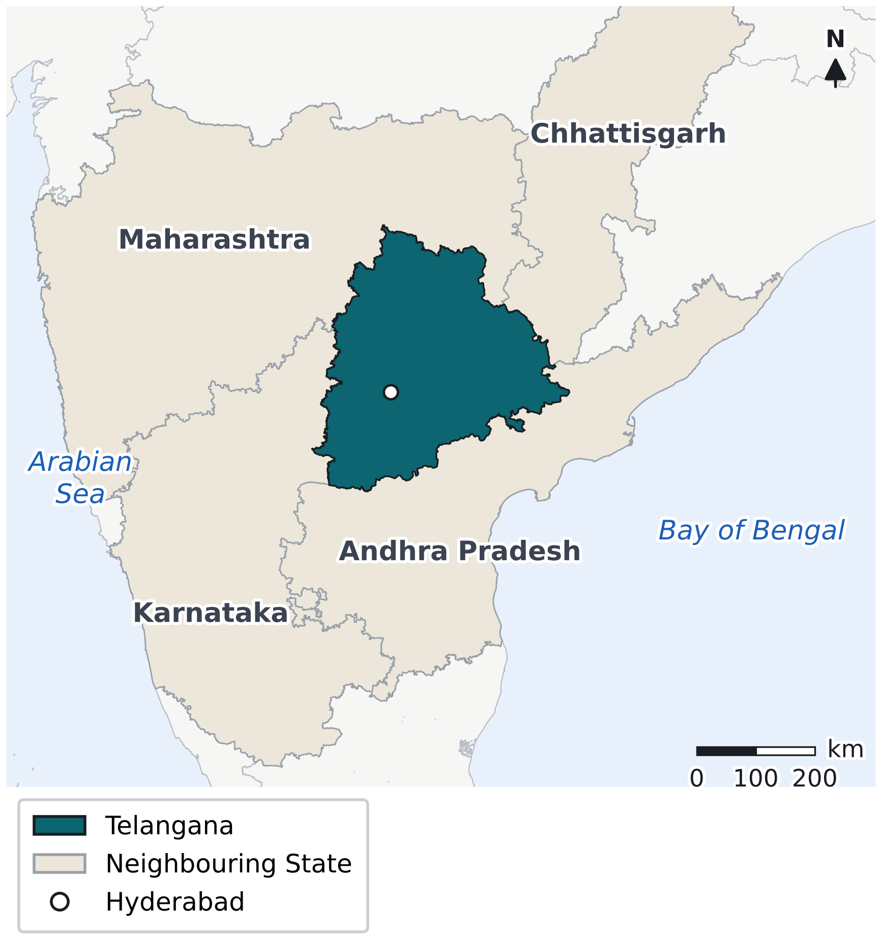
Notice that Telangana touches four States and no sea.
Source: Boundaries: Survey of India State boundaries and Local Government Directory districts (2019 framework), compiled by the Datameet community (indianopenmaps). Reference: current State boundaries.
Notes
- 1Imperial Gazetteer of India, Provincial Series: Hyderabad State (1909); Census of India 1941, Vol. XXI, Part I, p. 1. The Census of 1951, Vol. IX, Part II-A, Table A-I gives 82,168 square miles; the sq km figures are conversions.
- 2Computed for this chapter from the Survey of India State boundary, Local Government Directory districts (2019 framework) and India-WRIS layers, in a projected coordinate system; values are approximate and rounded.
- 3Socio Economic Outlook 2015 printed 1,14,840 sq km; the State Profile on telangana.gov.in and the Socio Economic Outlook 2024 give 1,12,077 sq km. An older Central Ground Water Board profile gives 1,15,150 sq km.
- 4Government of Telangana, State Profile (page updated December 2025) gives 612 revenue mandals; the Socio Economic Outlook 2024 gives 620 mandals. New mandals were notified in 2022–2024, so counts depend on the date and source.
- 5The Registrar General of India asked States not to change district, sub-district or tehsil boundaries between 1 January 2026 and 31 March 2027, for Census 2027 (reported by Business Standard, 29 June 2025); Telangana Today, 6 April 2026, reported the commission deferred till after that date.
- 6Central Ground Water Board, Ground Water Profile of Telangana State (cgwb.gov.in).