Administration & districts · Atlas of Telangana
Districts & headquarters of Telangana
All thirty-three, with their headquarters
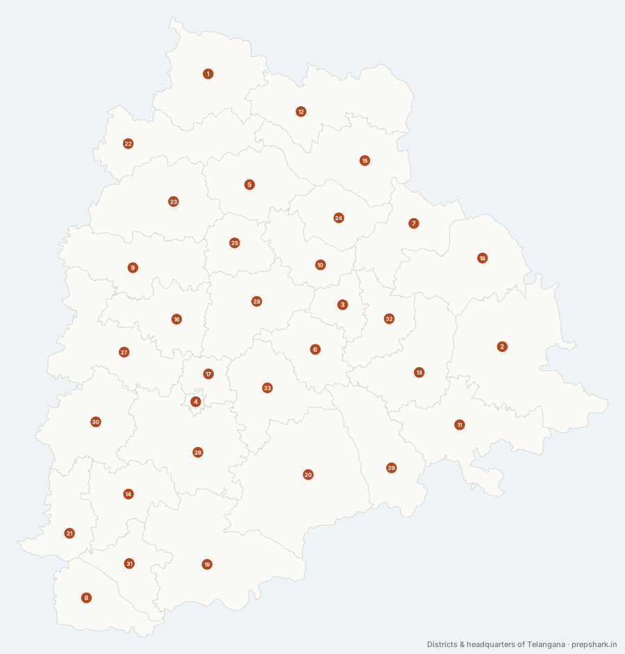
Numbered as on the map
The 33 on the map
1. Adilabad
Adilabad
Known forThe northern tip of the state, Gond country, and Kuntala falls.
The northernmost district in Telangana, and the one that feels least like the rest of it. It sits on the far side of the Godavari from the plateau proper, on the Maharashtra border, where the Penganga runs along the state line before joining the Wardha. The country here is hill and teak forest rather than tank-irrigated farmland, which is why the settlement pattern, the crops and the people are all different from the districts south of the river.
SettingNorthern plateau · Teak forest · Penganga valley · Cotton black soil
For the examThe northernmost district, and one of seven that touch Maharashtra. Kuntala on the Kadem, in Neredigonda mandal here, is the highest waterfall in the state — it is an Adilabad fall, not a Nirmal one, which is the commonest way to get it wrong.
2. Bhadradri Kothagudem
Bhadradri Kothagudem
Known forBhadrachalam on the Godavari, and the Singareni coalfield at Kothagudem.
The largest district in the state and the easternmost, hooked along the Godavari where the river leaves the plateau for the coastal plain. It has coal at Kothagudem, a temple town at Bhadrachalam, forest in between, and borders with both Chhattisgarh and Andhra Pradesh — a district that is really four places joined by a river.
SettingLower Godavari · Moist deciduous forest · Coal measures · Kinnerasani valley
For the examThe largest district by area (7,483 km²) and the easternmost. One of two that border both Chhattisgarh and Andhra Pradesh — the other is not a district but a point, where Jayashankar Bhupalpally meets Maharashtra.
3. Hanumakonda
Hanumakonda
Known forThe Thousand Pillar Temple, and the Kakatiya capital region.
The urban core of the old Warangal district and the seat of the Kakatiyas before Orugallu was built — which is why the Thousand Pillar Temple of 1163 is at Hanumakonda and the fort is at Warangal a few kilometres away. It is the most urbanised and the most literate district outside the Hyderabad group.
SettingGranite inselbergs · Urban plateau · Kakatiya tank fringe
For the examRenamed from Warangal Urban on 21 June 2021. Two mandals — Warangal and Khila Warangal — were transferred out of it to Warangal district in August 2021, after the boundary this map draws.
4. Hyderabad
Hyderabad
Known forCharminar, Golconda, the Qutb Shahi tombs, Hussain Sagar.
The smallest district in the state by a factor of five and the most populous, because it is not really a district at all — it is the old city and its immediate surroundings, drawn tight around the built-up area and entirely urban. The Musi runs through the middle of it, which is why the city is here: a rock-sided crossing with water above it.
SettingMusi valley · Granite outcrops · Wholly built up
For the exam217 km², the smallest; 3.94 million people, the largest; 100% urban and the only district that is. It is also the only one untouched by the 2016 reorganisation.
5. Jagtial
Jagtial
Known forDharmapuri on the Godavari, and the Kondagattu hill temple.
A strip between the Godavari on its north and the Manair country to its south, which is why it has both the river towns and the tank villages. Dharmapuri on the Godavari is one of the oldest continuously settled temple sites on the river in the state.
SettingGodavari right bank · Manair headwaters · Irrigated rice and turmeric
6. Jangaon
Jangaon
Known forPembarthi brass and sheet-metal craft, on the old tank belt.
A small inland district on the Kakatiya tank belt between Warangal and Hyderabad, with no river of consequence and no state boundary — everything it grows depends on stored water. Pembarthi, whose brass sheet-metal work goes back to the Kakatiyas, is the craft that outlasted the patronage.
SettingCentral plateau · Tank irrigation · Dry red soils
7. Jayashankar Bhupalpally
Jayashankar Bhupalpally
Known forKaleshwaram, at the Godavari–Pranahita confluence.
The only district that touches both Maharashtra and Chhattisgarh. Its north-eastern tip reaches the point where the Pranahita delivers itself into the Godavari, and all three states meet within a few kilometres of that confluence. That junction is why Kaleshwaram — the temple, and then the pumping scheme named after it — is here.
SettingGodavari–Pranahita confluence · Coal measures · Dry teak forest
For the examFour districts touch two states each, and this is the only one whose pair is Maharashtra and Chhattisgarh — the others are Kamareddy (Maharashtra and Karnataka), Bhadradri Kothagudem (Chhattisgarh and Andhra Pradesh) and Jogulamba Gadwal (Karnataka and Andhra Pradesh). Named for Kothapalli Jayashankar, the ideologue of the statehood movement.
8. Jogulamba Gadwal
Jogulamba Gadwal
Known forAlampur, at the Krishna–Tungabhadra confluence, and the Gadwal saree.
The southernmost district, in the wedge where the Tungabhadra meets the Krishna. That confluence is the reason for everything here: Alampur’s temples stand on it, the Jurala project uses it, and the district is the only one that touches both Karnataka and Andhra Pradesh.
SettingKrishna–Tungabhadra confluence · Southern dry plateau · Black cotton soils
For the examThe southernmost district and the only one bordering both Karnataka and Andhra Pradesh. The Jogulamba temple at Alampur is one of the eighteen Maha Shakti Peethas, and the Navabrahma temples beside it are Badami Chalukyan.
9. Kamareddy
Kamareddy
Known forThe Nizam Sagar on the Manjira, and the Domakonda fort.
Cut from Nizamabad in 2016 along the Manjira, and it took the river’s great work with it: the Nizam Sagar, built across the Manjira in the 1920s, is here rather than in the district it is named after. Its western edge runs out to both Maharashtra and Karnataka, which makes it one of only four districts in the state touching two.
SettingManjira valley · Plateau uplands · Tank and canal irrigation
For the examThe Nizam Sagar is in Kamareddy, not Nizamabad — a reorganisation trap that pre-2016 answer keys get wrong. Kamareddy also touches two states, Maharashtra and Karnataka, which is easy to miss because neither border is long.
10. Karimnagar
Karimnagar
Known forSilver filigree, granite, and the Lower Manair Dam.
The district of the Manair, the Godavari tributary that drains the north-eastern plateau, and one of only a handful with no state boundary at all — it is surrounded entirely by other districts. Granite underlies most of it, which is both the quarrying industry and the reason the surface water has to be stored rather than sunk.
SettingManair basin · Granite plateau · Tank-and-reservoir irrigation
For the examKarimnagar silver filigree carries a geographical indication. The district is landlocked within Telangana — six neighbours, no state line.
11. Khammam
Khammam
Known forThe Khammam fort on Stambhadri, and the Munneru valley.
The south-eastern corner of the state, on the Munneru — a Krishna tributary, not a Godavari one, which is what separates this district from the Godavari country immediately north of it. The fort on the Stambhadri rock is the reason a town grew here at all.
SettingMunneru valley · Krishna sub-basin · Red soils · Andhra Pradesh frontier
For the examKhammam drains to the Krishna by the Munneru, while its northern neighbour Bhadradri Kothagudem drains to the Godavari — the watershed runs between the two.
12. Kumuram Bheem Asifabad
Kumuram Bheem Asifabad
Known forNamed for the Gond leader of the Jodeghat revolt; the Pranahita border.
Carved out of Adilabad in 2016 and named for the Gond leader Kumram Bheem, whose revolt against the Nizam was fought in these hills. It runs along the Maharashtra border down to where the Pranahita — the Wainganga and the Wardha, joined — forms the state line before delivering the largest of the Godavari tributaries to it.
SettingForested northern hills · Pranahita valley · Gond and Kolam country
For the examOne of two districts named after a person from the tribal resistance. It borders Maharashtra, not Chhattisgarh — the Chhattisgarh border begins further east.
13. Mahabubabad
Mahabubabad
Known forForested eastern hills with a large Koya and Lambada population.
The eastern hill country south of Warangal, where the plateau breaks up into forested ridges before it falls towards the Godavari lowland. That terrain is why the district has one of the largest tribal shares in the state, and why the settlements follow valleys rather than roads.
SettingEastern hill tracts · Dry deciduous forest · Tribal settlement
14. Mahabubnagar
Mahabubnagar
Known forPalamoor, the drought and out-migration belt, and the Pillalamarri banyan.
Palamoor: the driest large district in the state and the one that exported labour for a century because of it. Since 2016 it no longer reaches the Krishna — Wanaparthy, Nagarkurnool and Jogulamba Gadwal took the river frontage with them — so the district that is synonymous with south Telangana’s water problem is now entirely inland.
SettingSouthern dry plateau · Low rainfall · Red gravelly soils
For the examAfter 2016 Mahabubnagar does not touch the Krishna. A question that puts a Krishna project "in Mahabubnagar" is working from the old district.
15. Mancherial
Mancherial
Known forSingareni coal on the Godavari, and the Kawal Tiger Reserve.
The district the Godavari enters after the Pranahita has joined it, and the one where the river runs over the Gondwana coal measures. That single geological fact is most of what the district is: Singareni has worked these seams since the nineteenth century, and the towns here are pit towns in a way nowhere else in the state is.
SettingGodavari valley · Gondwana coal measures · Dry teak forest
For the examHolds Kawal Tiger Reserve, the northern of the state’s two. Notified in 2012, it is the source end of the corridor that runs to Tadoba in Maharashtra.
16. Medak
Medak
Known forThe Medak Cathedral and the Medak fort, on the same low ridge.
One of the ten districts of 2014, reduced to a third of itself in 2016 when Sangareddy and Siddipet were taken out of it. What is left is the upland between the Manjira and the Haldi Vagu — dry, thinly urbanised, and holding two of the most recognisable buildings in the state.
SettingManjira uplands · Dry plateau · Tank irrigation · Deciduous scrub
For the examOnly 7.67% urban — one of the least urbanised districts in the state, and a striking contrast with Medchal–Malkajgiri an hour to its south.
17. Medchal–Malkajgiri
Medchal–Malkajgiri
Known forThe urban north of Hyderabad, and Shamirpet lake.
The northern arc of the Hyderabad conurbation, made a district in 2016 when it became clear that the city had already crossed its own boundary. Nearly all of its 2.4 million people live in continuous built-up area, which makes it the second densest district in the state and the second most urban.
SettingUrbanised plateau · Granite sheets · Tank remnants
For the exam91.4% urban and 2,251 people per km² — after Hyderabad itself, the most urban and the densest district. Its headquarters is Shamirpet.
18. Mulugu
Mulugu
Known forRamappa, Medaram and Laknavaram — the temple, the jatara and the lake.
The forest district. Created in 2019 out of Jayashankar Bhupalpally, it is the least populated in the state by a wide margin because most of it is the Eturnagaram–Tadvai forest belt running to the Chhattisgarh border — the same country that carries the Godavari’s left-bank tributaries down out of the hills.
SettingMoist deciduous forest · Godavari left-bank tributaries · Chhattisgarh frontier
For the examThe least populated district in Telangana. It holds the state’s only World Heritage Site — Kakatiya Rudreshwara, the Ramappa Temple at Palampet, inscribed in 2021 — and Medaram, whose Sammakka–Saralamma jatara is the largest tribal gathering in the country.
19. Nagarkurnool
Nagarkurnool
Known forAmrabad Tiger Reserve, in the Nallamala hills above the Krishna.
The third largest district, and almost all of the extra area is forest: the Nallamala hills run through its southern half down to the Krishna, and Amrabad Tiger Reserve covers most of them. It is the one district where Telangana stops being plateau farmland and becomes hill wilderness.
SettingNallamala hills · Dry deciduous forest · Krishna gorge · Chenchu homeland
For the examAmrabad is among the largest tiger reserves in the country. The Chenchu, a particularly vulnerable tribal group, live inside it.
20. Nalgonda
Nalgonda
Known forThe Krishna frontier, Nagarjuna Sagar, and endemic fluorosis.
The second largest district, lying along the Krishna where it forms the Andhra Pradesh border, and the place the Musi finally reaches after crossing Hyderabad. Its granites carry fluoride into the groundwater, which made Nalgonda the standing Indian example of endemic fluorosis long before anyone had piped surface water to it.
SettingKrishna right bank · Granite plateau · Fluoride groundwater · Musi confluence
For the examThe standard case study for fluoride in groundwater. The Musi joins the Krishna at Wazirabad in this district, which is why Hyderabad’s water quality is a Nalgonda problem.
21. Narayanpet
Narayanpet
Known forThe Narayanpet saree, and the Bhima on the Karnataka border.
The westernmost district, created with Mulugu in 2019, and the only one where the Bhima reaches Telangana — it runs along the Karnataka border before joining the Krishna just outside the state. The weaving tradition here is old enough to have borrowed from Maratha as well as Deccani looms.
SettingWestern dry plateau · Bhima and Krishna frontier · Black soils
For the examThe westernmost district, and one of two created on 17 February 2019. The Bhima touches Telangana only here.
22. Nirmal
Nirmal
Known forSri Ram Sagar at Pochampad, Basara, and Nirmal painted toys.
The district the Godavari runs along rather than through — it forms the southern boundary, with Nizamabad on the far bank. That is why the state’s oldest major storage on the river, the Sri Ram Sagar Project at Pochampad, is here: the site is where a plateau rim gives a dam a bank to sit on.
SettingGodavari left bank · Plateau scarp · Kadem valley · Teak
For the examNirmal toys and paintings carry a geographical indication. Basara, on the Godavari here, holds one of the few Saraswati temples in the country.
23. Nizamabad
Nizamabad
Known forThe Godavari–Manjira fork, turmeric, and the most mandals in the state.
Sits in the fork between the Godavari and its largest right-bank tributary the Manjira, which is the reason it is the best-watered district in the north and the one with the most mandals of any in the state. Turmeric and maize here are a consequence of that water, not of the soil.
SettingGodavari–Manjira doab · Red and black soils · Irrigated turmeric and maize
For the examThirty-four mandals, more than any other district. Not to be confused with Kamareddy next door, which took the Nizam Sagar with it in 2016.
24. Peddapalli
Peddapalli
Known forRamagundam — the coal, the thermal power, and the Godavari that cools it.
Coal and the Godavari in the same place, which is what makes it the state’s power district: the Ramagundam stations burn Singareni coal mined a few kilometres away and cool with Godavari water. The Sripada Yellampalli barrage on the river here is also the link that carries Kaleshwaram’s lifted water onward.
SettingGodavari valley · Gondwana coalfield · Industrial river towns
For the examRamagundam is the state’s largest thermal power complex, and the coal, the water and the load are all within a few kilometres of each other — the textbook case of a pithead station.
25. Rajanna Sircilla
Rajanna Sircilla
Known forThe Vemulawada Rajanna temple, powerloom weaving, and Mid Manair.
Named for the Rajanna of Vemulawada, whose temple is the reason the district has a name rather than just a headquarters. It sits on the middle Manair, which is why the Kaleshwaram system’s Mid Manair reservoir — the point where lifted Godavari water is handed on to the south — is here.
SettingMiddle Manair · Granite uplands · Reservoir irrigation
26. Rangareddy
Rangareddy
Known forOsman Sagar and Himayat Sagar, and the Shamshabad airport.
The district Hyderabad grew into, wrapped around the city’s south and west. Both of the old city reservoirs — Osman Sagar and Himayat Sagar, built on the Musi and its tributary after the 1908 flood — are here, and so is the airport at Shamshabad, which is its headquarters.
SettingMusi headwaters · Granite plateau · Peri-urban sprawl
For the examIts headquarters is Shamshabad, not Hyderabad — one of five districts whose seat is not the town it is named after. Mrugavani National Park, one of the state’s three, is inside it.
27. Sangareddy
Sangareddy
Known forThe Singur dam on the Manjira, and the Patancheru industrial belt.
The district that supplies Hyderabad with both water and factories. The Singur dam on the Manjira here is one of the city’s sources, and the Patancheru belt on its south-eastern edge is the oldest heavy industrial and pharmaceutical concentration in the state — close enough to the city to use it, far enough out to be permitted.
SettingManjira valley · Plateau edge · Industrial corridor · Crocodile habitat
For the examThe Manjira Wildlife Sanctuary, along the river’s reservoirs here, is protected for the mugger crocodile and its water birds — an unusual case of a sanctuary that is a working water supply.
28. Siddipet
Siddipet
Known forThe Kaleshwaram reservoirs — Mallanna Sagar and Ranganayaka Sagar.
Sits on the watershed in the middle of the state and touches eight districts, more than any other — which is exactly why the Kaleshwaram system routes through it. Water lifted out of the Godavari 200 km north is held here, in Mallanna Sagar and Ranganayaka Sagar, because from this height it can be let down in several directions at once.
SettingCentral watershed · Plateau uplands · Large new reservoirs
For the examEight neighbouring districts, the most of any. Its position on the central divide is why the Kaleshwaram storages are here rather than nearer the river.
29. Suryapet
Suryapet
Known forPhanigiri, and the Nagarjuna Sagar left bank canal.
Sits on the Krishna where the national highway between Hyderabad and the coast crosses the district, which is what made it a route town long before it was a district. Nagarjuna Sagar’s left bank canal waters most of it — the reason its farmland looks nothing like Nalgonda’s next door.
SettingKrishna right bank · Canal-irrigated plain · Dry deciduous scrub
For the examPhanigiri is one of the most important Buddhist sites in the state — a hilltop monastery of the Ikshvaku period whose sculpture is the reason the Krishna valley matters to art history.
30. Vikarabad
Vikarabad
Known forThe Anantagiri hills, where the Musi rises.
The high western edge of the plateau, and the district where Hyderabad’s own river begins — the Musi rises in the Anantagiri hills here before running east through the city. Higher, cooler and more wooded than anything around it, on the Karnataka border.
SettingAnantagiri hills · Plateau rim · Dry deciduous forest · Musi source
For the examThe Musi — the river Hyderabad is built on and Nalgonda has to drink — rises in this district.
31. Wanaparthy
Wanaparthy
Known forThe Wanaparthy samsthan, and the Sarala Sagar siphon dam.
One of the samsthans — the tributary princely estates under the Nizam — and it kept the name when it became a district in 2016. It reaches the Krishna at the southern edge, just below where the Tungabhadra comes in, which is why the Jurala command runs through it.
SettingSouthern plateau · Krishna right bank · Dry irrigated tracts
For the examSarala Sagar is one of the very few siphon-operated dams in Asia — it discharges without gates or motors.
32. Warangal
Warangal
Known forPakhal — a Kakatiya tank that became a wildlife sanctuary.
The rural half of the old Warangal district, and the half that holds the tanks. Pakhal, built by the Kakatiyas in the thirteenth century and still irrigating, is here, and so is the forest that grew up around it — which is why a district defined by its farmland also holds a wildlife sanctuary.
SettingEastern plateau · Kakatiya tank country · Moist deciduous forest
For the examCalled Warangal Rural from 2016 until June 2021, when Warangal Urban was renamed Hanumakonda and this district took the name Warangal. An answer key written between those dates uses the other name.
33. Yadadri Bhuvanagiri
Yadadri Bhuvanagiri
Known forYadagirigutta and the Bhuvanagiri monolith fort.
A district of granite domes rising out of flat farmland east of Hyderabad, and the two biggest of them carry its two halves of the name: the Lakshmi Narasimha temple on the Yadagirigutta hill and the fort on the single monolith at Bhuvanagiri. Both exist because the rock was there.
SettingGranite inselbergs · Dry plateau · Tank irrigation
For the examRenamed from Yadadri to Yadadri Bhuvanagiri in January 2017. Kolanupaka in this district holds one of the oldest Jain temples in the Deccan.
Keep going