Administration & districts · Atlas of Telangana
The ten districts of 2014 of Telangana
The map every pre-2016 answer key uses
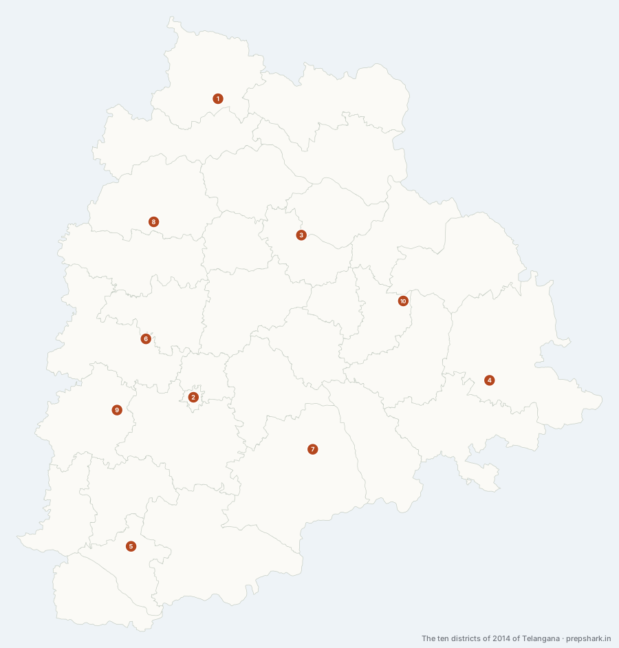
Numbered as on the map
The 10 on the map
1. Erstwhile Adilabad
Adilabad
Known forThe forested north, split four ways in 2016.
The whole north of the state as one district — 16,116 km², second only to Mahabubnagar, and almost all of it forest, hill and Gond country above the Godavari. In 2016 it was cut into four: Adilabad kept the name and the north-west, Kumuram Bheem Asifabad took the Pranahita border, Mancherial took the coal reach of the Godavari and Nirmal took the Sri Ram Sagar country in the south-west.
SettingNorthern hill and teak country · Godavari north bank · Gond and Kolam homeland
For the examFour successors: Adilabad, Kumuram Bheem Asifabad, Mancherial and Nirmal. One of the eight districts the Telangana region of Hyderabad State held in 1948.
2. Erstwhile Hyderabad
Hyderabad
Known forThe one district of the ten left untouched in 2016.
The only one of the ten that the 2016 reorganisation did not touch at all, and by a long way the smallest at 175 km². It had already been through its own division in 1978, when Hyderabad district was split into an urban half that kept the name and a rural half that became Ranga Reddy — so by 2014 it was the city and almost nothing else.
SettingMusi valley · Granite outcrops · Wholly built up
For the examUntouched by the 2016 reorganisation and unchanged since. Its rural half had already left in 1978 to become Ranga Reddy.
3. Erstwhile Karimnagar
Peddapalli
Known forThe Manair basin and Ramagundam, split four ways.
The Manair basin and the Godavari’s coal reach as one district of 11,851 km², holding both the granite country around Karimnagar town and the pit towns at Ramagundam. It became four in 2016 — Karimnagar, Jagtial, Peddapalli and Rajanna Sircilla — and the split put the coal and the power stations in Peddapalli while the name stayed with the granite.
SettingManair basin · Godavari coal reach · Granite plateau
For the examIts own centre is now in Peddapalli, not in Karimnagar — the clearest case on this layer of an old district whose middle changed name. Four successors: Karimnagar, Jagtial, Peddapalli and Rajanna Sircilla.
4. Erstwhile Khammam
Bhadradri Kothagudem
Known forThe eastern forest-and-coal district, created in 1957 and split in 2016.
The youngest of the ten and the third largest at 16,007 km² — created in 1957 by cutting Warangal in half, then enlarged when the Bhadrachalam division was transferred in from the Godavari districts. In 2016 it became Khammam and Bhadradri Kothagudem, and that split follows the watershed: Khammam drains to the Krishna, Bhadradri to the Godavari.
SettingLower Godavari · Munneru valley · Moist deciduous forest · Coal measures
For the examCreated on 1 October 1957 out of Warangal, so it is not one of the eight districts of 1948. Seven mandals of its Bhadrachalam division were returned to East Godavari in Andhra Pradesh when the state was divided in 2014.
5. Erstwhile Mahbubnagar
Wanaparthy
Known forPalamoor — the largest of the ten, and the driest.
The largest of the ten at 18,392 km², and the poorest — Palamoor, the district that exported labour for a century because it had the least water. The whole southern quarter of the state, from the Karnataka border along the Krishna to the Nallamala. It became five: Mahabubnagar, Wanaparthy, Nagarkurnool and Jogulamba Gadwal in 2016, then Narayanpet in 2019.
SettingSouthern dry plateau · Krishna–Tungabhadra frontier · Nallamala hills · Low rainfall
For the examThe largest district at the state’s formation, at 18,392 km². Five successors, and the modern Mahabubnagar that kept the name no longer touches the Krishna at all.
6. Erstwhile Medak
Sangareddy
Known forThe western plateau, split into Medak, Sangareddy and Siddipet.
The western plateau between the Manjira and the central divide, 9,689 km², reaching from the Karnataka border across to what is now Kaleshwaram’s reservoir country. It became Medak, Sangareddy and Siddipet in 2016, and the three are barely comparable: Sangareddy took the industry and Hyderabad’s water, Siddipet took the watershed, and Medak kept the name and the least urbanised third.
SettingManjira valley · Central watershed · Dry plateau uplands
For the examThree successors: Medak, Sangareddy and Siddipet. Its centre is now in Sangareddy.
7. Erstwhile Nalgonda
Nalgonda
Known forThe Krishna’s north bank, split into Nalgonda, Suryapet and Yadadri Bhuvanagiri.
The Krishna’s north bank as one district of 14,210 km², from the Musi’s arrival out of Hyderabad down to Nagarjuna Sagar and east along the Andhra Pradesh border. It became Nalgonda, Suryapet and Yadadri Bhuvanagiri in 2016, and its centre is one of the few on this layer that is still in a district of the same name.
SettingKrishna right bank · Granite plateau · Fluoride groundwater · Musi confluence
For the examThree successors: Nalgonda, Suryapet and Yadadri Bhuvanagiri. The fluorosis belt and Nagarjuna Sagar both stayed with Nalgonda.
8. Erstwhile Nizamabad
Nizamabad
Known forThe two-river fork, split only in two.
The Godavari–Manjira fork, 7,953 km², and the best-watered of the ten because both rivers run through it. It split only in two — Nizamabad and Kamareddy — which makes it the least reorganised district on this layer apart from Hyderabad, and the split still managed to move the Nizam Sagar out of the district it is named after.
SettingGodavari–Manjira doab · Irrigated turmeric and maize · Red and black soils
For the examTwo successors: Nizamabad and Kamareddy. The Nizam Sagar went to Kamareddy, which is the commonest reorganisation trap in the whole state.
9. Erstwhile Ranga Reddy
Vikarabad
Known forHyderabad’s rural ring, split three ways in 2016.
The ring around Hyderabad, 7,506 km², created in 1978 out of Hyderabad’s rural half and named after K. V. Ranga Reddy. It became Rangareddy, Medchal–Malkajgiri and Vikarabad in 2016 — a split that separated the part the city had already swallowed from the part it had not reached.
SettingMusi headwaters · Granite plateau · Peri-urban sprawl · Anantagiri hills
For the examCreated on 15 August 1978 as Hyderabad Rural, renamed Ranga Reddy. Three successors: Rangareddy, Medchal–Malkajgiri and Vikarabad. Its centre is now in Vikarabad.
10. Erstwhile Warangal
Warangal
Known forThe Kakatiya heartland, split six ways across two reorganisations.
The Kakatiya heartland and the eastern forests as one district of 12,810 km². It is the most reorganised of the ten: six districts have come out of it — Warangal, Hanumakonda, Jayashankar Bhupalpally, Mahabubabad, Jangaon in 2016 and Mulugu in 2019 — and two of those six then swapped names in 2021.
SettingKakatiya tank country · Eastern moist deciduous forest · Godavari left bank
For the examSix successors, more than any other: Warangal, Hanumakonda, Jayashankar Bhupalpally, Mahabubabad, Jangaon and Mulugu. Khammam had already been cut out of it in 1957, before the ten existed.
Keep going