Culture & heritage · Atlas of Telangana
Forts of Telangana
Kakatiya, Qutb Shahi and Asaf Jahi forts
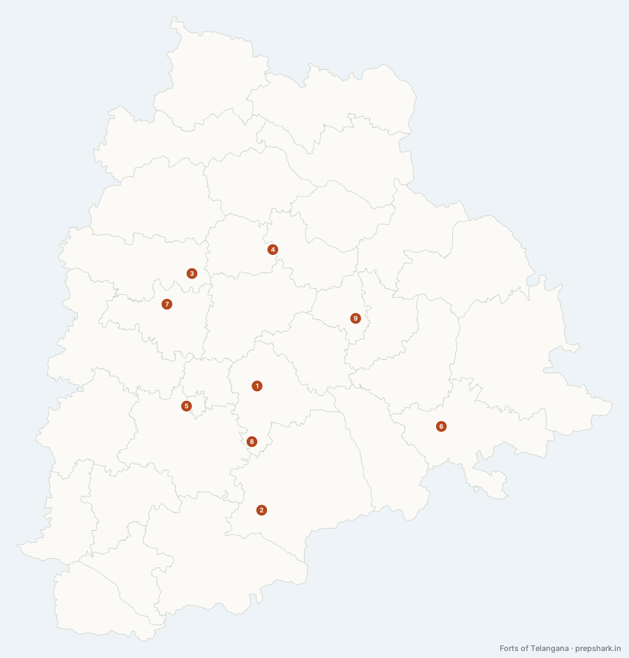
Numbered as on the map
The 9 on the map
1. Bhongir Fort
Yadadri Bhuvanagiri
Known forA fort on one granite monolith, 130 m above the plain.
A single egg-shaped granite dome rising 130 m out of flat farmland, fortified in the tenth century by the Western Chalukyan Tribhuvanamalla — whose name the town carries as Bhuvanagiri. It is the clearest example on the layer of the rule the whole fort line follows: the rock came first, and everything built here was built because the rock was unclimbable.
SettingGranite inselberg · Dry plateau · Tank farmland
For the examNamed after Tribhuvanamalla Vikramaditya VI; Bhuvanagiri is a contraction of his name, and Bhongir is a contraction of that.
2. Devarakonda Fort
Nalgonda
Known forThe southern Velama fort, and its rock-cut water system.
The southern Velama seat, on a cluster of seven hills in the dry country between the Musi and the Krishna. It holds what Rachakonda does not — a working system of rock-cut cisterns — which is why a fort in one of the driest districts in the state could be held through a siege.
SettingGranite hill cluster · Fluoride groundwater country · Dry scrub
3. Domakonda Fort
Kamareddy
Known forA samsthan palace-fort, not a military one.
Not a hill fort at all but a walled palace complex of the Kamineni samsthan — one of the tributary estates the Nizams left in place — built on flat ground in the eighteenth century in a Deccan style that borrows from both Rajput and Mughal work. It is the layer’s example of fortification as status rather than as defence.
SettingManjira uplands · Plateau farmland · Samsthan landscape
4. Elgandal Fort
Karimnagar
Known forA four-dynasty fort on the Manair, and the old Karimnagar seat.
A fort that changed hands through four dynasties — Kakatiya, Bahmani, Qutb Shahi, Asaf Jahi — without ever being the seat of any of them, which makes it the best illustration on this layer of what a district-level stronghold was for. It stands on the Manair, and the river is the moat on one side.
SettingManair valley · Granite plateau · Riverside fortification
For the examElgandal was the district headquarters before Karimnagar was; the administrative centre moved off the fort in the Asaf Jahi period.
5. Golconda Fort
Hyderabad
Known forThe Qutb Shahi capital, and the reason Hyderabad was founded.
A granite hill on the western edge of the Hyderabad plateau, fortified in mud by the Kakatiyas and rebuilt in stone by the Qutb Shahis as their capital. The city moved off it to the Musi in 1591 for one reason a geographer should recognise: a hill fort has no water of its own, and a dynasty cannot grow on rainwater tanks.
SettingGranite outcrop · Musi catchment · Urban
For the examThe move from Golconda to the new city on the Musi in 1591 is a water story, not a military one.
6. Khammam Fort
Khammam
Known forThe Stambhadri rock, and the road east.
Built on the Stambhadri outcrop that gave the town its name, and the reason there is a town here at all: it is the last defensible rock on the road east before the country falls away towards the Godavari lowland and the coast. Kakatiya foundations, Qutb Shahi walls, and a position that mattered to everyone who wanted the route.
SettingGranite outcrop · Munneru valley · Krishna sub-basin
7. Medak Fort
Medak
Known forA Kakatiya hill fort above the town with the cathedral.
A Kakatiya hill fort on the western plateau that the Qutb Shahis took and rebuilt, standing over the town that later got the cathedral. The two together are why Medak is worth a stop on a heritage route: a thirteenth-century fort and a 1924 church on the same low ridge, three centuries and two empires apart.
SettingPlateau ridge · Manjira uplands · Dry deciduous scrub
8. Rachakonda Fort
Yadadri Bhuvanagiri
Known forThe Recherla Velama seat, paired with Devarakonda.
The seat of the Recherla Velamas, who took the eastern half of the Kakatiya country after Warangal fell and held it from a hill in broken granite country south-east of Hyderabad. Its pair, Devarakonda, is forty kilometres further south — the two together are why this stretch of Nalgonda and Yadadri is full of fortified rock.
SettingGranite hill country · Musi–Krishna divide · Dry scrub
9. Warangal Fort
Hanumakonda
Known forThe Kakatiya capital, defended by rings rather than by a hill.
The Kakatiya capital, and unlike almost every other fort on this layer it is not on a hill. Orugallu was built on flat ground and defended by rings — an inner granite wall raised by Ganapati Deva and an outer earthen curtain added by Rudrama Devi — which is what a dynasty does when it is confident enough to fortify its farmland instead of retreating to a rock.
SettingKakatiya tank country · Granite plain · Urban
For the examIts four ornamental gateways, the Kakatiya Kala Thoranam, are the state emblem of Telangana. On the boundary this map draws, the fort falls in Hanumakonda; the Warangal and Khila Warangal mandals were transferred to Warangal district in August 2021.
Keep going