Physical geography · Atlas of Telangana
The Godavari & its tributaries of Telangana
The northern river and its tributaries
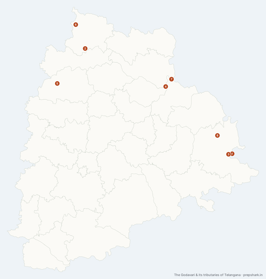
Numbered as on the map
The 8 on the map
1. Godavari
Bhadradri Kothagudem
Known forThe state’s northern river, and the second longest in India.
The river the northern two-thirds of Telangana drains into. It enters from Maharashtra in the north-west, runs east along or through eight districts gathering the Manjira, the Manair and then the Pranahita, and turns south at Bhadrachalam to leave for the Andhra coast. The pin is at that turn, because it is the point on the river a Telangana paper actually asks about.
SettingDeccan trap and Gondwana basin · Eight districts · Monsoon regime
For the examEight districts: Nirmal, Nizamabad, Jagtial, Mancherial, Peddapalli, Jayashankar Bhupalpally, Mulugu and Bhadradri Kothagudem. Its largest tributary anywhere, the Pranahita, joins it inside the state at Kaleshwaram.
2. Kadem
Adilabad
Known forThe Kuntala fall, and the Kadem project.
A short left-bank tributary off the northern hills, and out of proportion to its size in what it carries. The Kuntala fall — the highest in the state, in Neredigonda mandal in Adilabad — drops off the scarp on its upper course, and one of the earliest post-independence projects in the region is built across it further down in Nirmal.
SettingNorthern hill drainage · Teak catchment · Waterfall scarp
3. Kinnerasani
Bhadradri Kothagudem
Known forThe reservoir that cools Kothagudem, inside a wildlife sanctuary.
Comes down off the eastern forest to join the Godavari near Bhadrachalam. It is dammed above the confluence to cool the Kothagudem power station, and the forest around the resulting reservoir is a wildlife sanctuary — three uses of one small river within twenty kilometres.
SettingEastern forest drainage · Reservoir · Moist deciduous catchment
4. Manair
Peddapalli
Known forThe state’s own river, and the Kaleshwaram system’s spine.
An entirely internal river: it rises on the plateau in the north, runs east through Rajanna Sircilla and Karimnagar, and joins the Godavari without ever leaving Telangana. That is why the Kaleshwaram system uses it as its spine — water lifted from the Godavari is put into the Manair at Mid Manair and let down the same valley the river already cut.
SettingGranite plateau drainage · Mid and Lower Manair reservoirs · Wholly internal basin
For the examAlso spelt Maner. Both Mid Manair and Lower Manair are on it, which is what makes it the link between the Kaleshwaram lift and the districts it serves.
5. Manjira
Nizamabad
Known forThe western river that supplies Hyderabad and waters the Nizamabad plain.
The Godavari’s main right-bank tributary in the state, coming up from Karnataka through the western plateau. It is the most heavily worked river in Telangana for its size — the Nizam Sagar and the Singur are both on it — because it is the only substantial river on the side of the state where Hyderabad happens to be.
SettingWestern plateau · Nizam Sagar and Singur reservoirs · Crocodile habitat
For the examThree districts: Sangareddy, Kamareddy and Nizamabad. Both the Nizam Sagar and the Singur are on it, and so is the Manjira Wildlife Sanctuary.
6. Penganga
Adilabad
Known forThe northern boundary river, feeding the Wardha.
Runs along the top of the state as the Telangana–Maharashtra boundary before joining the Wardha, and so reaches the Godavari only by way of the Pranahita. It is the reason Adilabad is cut off from the north: the district’s hill country ends at this river rather than at a road.
SettingNorthern hill drainage · Interstate boundary · Teak catchment
7. Pranahita
Jayashankar Bhupalpally
Known forThe Godavari’s largest tributary, joining it at Kaleshwaram.
The Wainganga and the Wardha join in Maharashtra to make the Pranahita, which then runs down the Telangana border and delivers more water to the Godavari than any other tributary of it. That volume, arriving at a known point, is the reason the Kaleshwaram lift was built where it was: the scheme is an answer to the question of what to do with water that is already there.
SettingBorder river · Wainganga–Wardha drainage · Riverine forest corridor
For the examThe Pranahita carries the largest flow of any Godavari tributary. Its confluence at Kaleshwaram is also where Telangana, Maharashtra and Chhattisgarh come together.
8. Taliperu
Bhadradri Kothagudem
Known forThe project that irrigates the eastern agency tracts.
A left-bank tributary of the Godavari running through the forest of the state’s far east, dammed to irrigate the agency tracts around Charla and Cherla. It matters as a case rather than as a river: it is the water that makes settled farming possible in a district that is otherwise forest and coal.
SettingEastern forest drainage · Agency tract irrigation · Moist deciduous catchment
Keep going