Physical geography · Atlas of Telangana
The Krishna & its tributaries of Telangana
The southern river and its tributaries
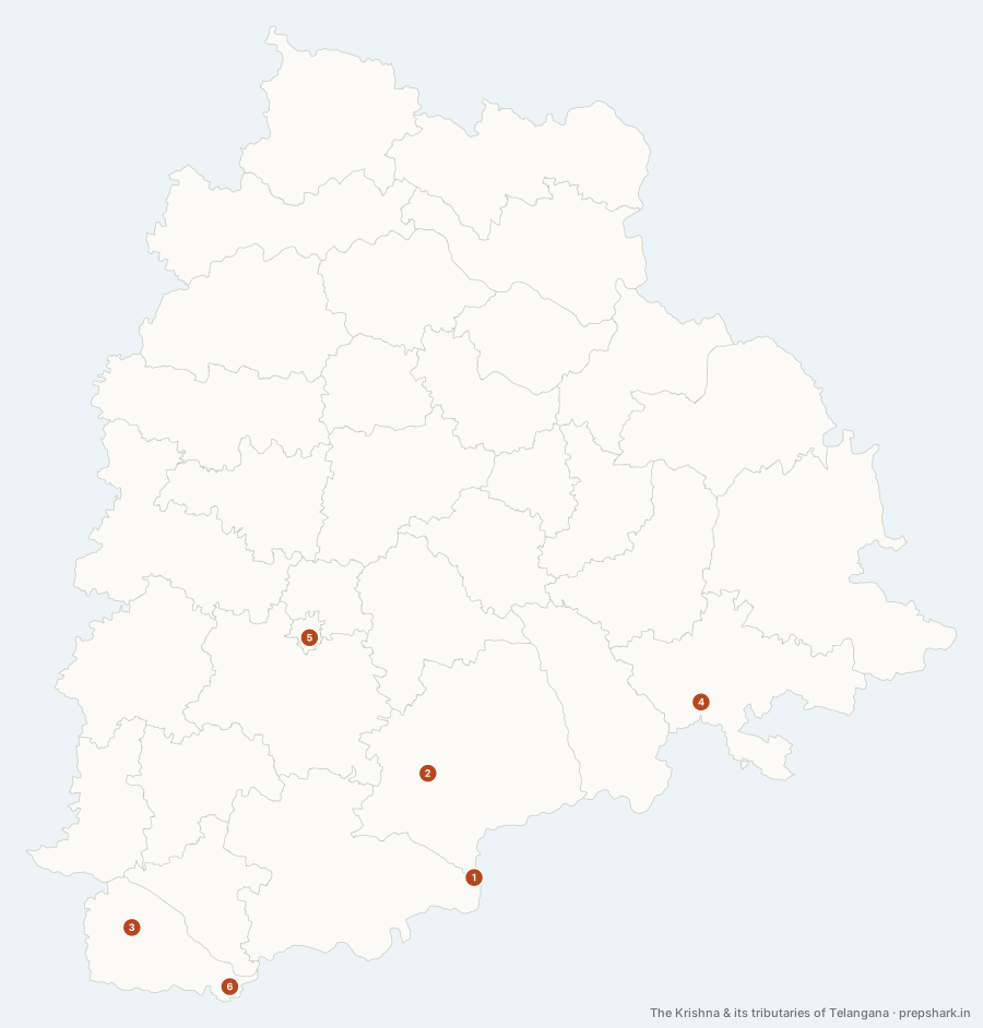
Numbered as on the map
The 6 on the map
1. Dindi
Nagarkurnool
Known forThe Nallamala tributary the Dindi lift follows.
A right-bank tributary coming off the plateau into the Krishna through the Nallamala, and the line the Dindi lift scheme follows to carry Krishna water back up onto the dry uplands of Nalgonda. It is a small river doing a large amount of administrative work.
SettingNallamala drainage · Dry deciduous catchment · Lift irrigation corridor
2. Halia
Nalgonda
Known forThe Nalgonda tributary behind the district’s groundwater problem.
Drains the fluoride-bearing granites of central Nalgonda into the Krishna, which is why the district’s water problem is a surface-water answer to a groundwater question: the Halia carries little enough that villages here sank borewells instead, and the borewells are the fluorosis.
SettingGranite plateau drainage · Fluoride-bearing catchment · Seasonal flow
3. Krishna
Jogulamba Gadwal
Known forThe southern boundary river, dammed twice on the state line.
The southern river, and for most of its Telangana length it is not in the state so much as beside it — the Krishna forms the boundary with Andhra Pradesh from Jogulamba Gadwal round to Suryapet. It arrives from Karnataka at the state’s south-western corner, takes the Tungabhadra at Alampur a few kilometres downstream, cuts a gorge through the Nallamala, and is dammed twice on the state line at Srisailam and Nagarjuna Sagar.
SettingSouthern plateau · Nallamala gorge · Interstate boundary · Two major storages
For the examSix districts: Narayanpet, Jogulamba Gadwal, Wanaparthy, Nagarkurnool, Nalgonda and Suryapet. Mahabubnagar does NOT touch the Krishna after the 2016 reorganisation.
4. Munneru
Khammam
Known forThe river that puts Khammam in the Krishna basin.
The reason Khammam belongs to the Krishna basin while everything north of it belongs to the Godavari. The Munneru drains the south-eastern corner of the state and runs down to the Krishna in Andhra Pradesh, so the watershed — invisible on the ground — runs between Khammam and Bhadradri Kothagudem.
SettingSouth-eastern drainage · Red soils · Krishna sub-basin
5. Musi
Hyderabad
Known forHyderabad’s own river, from the Anantagiri hills to the Krishna.
Rises in the Anantagiri hills in Vikarabad, runs east through the middle of Hyderabad, and joins the Krishna at Wazirabad on the Nalgonda–Suryapet boundary. It is the reason the city is where it is, the reason the city has two reservoirs — Osman Sagar and Himayat Sagar were built after the flood of 1908 — and the reason Nalgonda’s water quality is a Hyderabad problem.
SettingGranite plateau drainage · Urban river · Two flood-control reservoirs
For the examIt rises in Vikarabad and reaches the Krishna at Wazirabad on the Nalgonda–Suryapet line, running through Rangareddy, Hyderabad, Medchal–Malkajgiri, Yadadri Bhuvanagiri and Nalgonda on the way — Yadadri Bhuvanagiri holds the longest stretch of it, which answer keys that say “four districts” miss. The 1908 Musi flood is what produced both Osman Sagar and Himayat Sagar and the city plan that followed them.
6. Tungabhadra
Jogulamba Gadwal
Known forJoining the Krishna at Alampur, at the state’s southern tip.
The Krishna’s largest tributary, arriving from Karnataka at the southernmost point of Telangana. The confluence at Alampur is why there is a temple complex there — a sangam is a site before it is a river junction — and it is the single most examinable point on the state’s southern edge.
SettingSouthern dry plateau · River confluence · Black cotton soils
For the examThe Krishna–Tungabhadra confluence at Alampur, sometimes called Sangameswaram, is in Jogulamba Gadwal — the only district touching both Karnataka and Andhra Pradesh.
Keep going