Environment & ecology · Atlas of India
Elephant corridors of India
Protected areas, habitats, and the corridors between them.
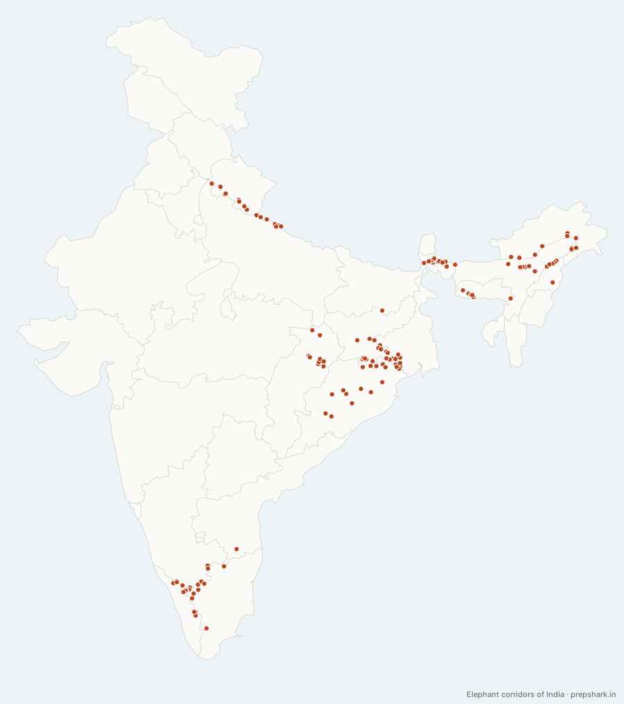
Numbered as on the map
The 150 on the map
1. Abhaypur-Singphan
Nagaland
Known forMon of Singhpan Wildlife to Abhaypur Reserve Forest in Sonari
A corridor carrying elephants from the Mon of Singhpan Wildlife Sanctuary in Nagaland to Abhaypur Reserve Forest in Sonari Forest Division of Assam across Tiru River. Corridor falls within the Singhpan Wildlife Sanctuary in Mon District, about 5 km of it. The ground it crosses is forest, and it is used regularly. Crossed by Village road-8 km.
SettingTropical semi-evergreen · Forest · 5 km long · regular movement
2. Anaikat t i North-Anaikat t i South
Tamil Nadu
Known forAnakatti North Reserve Forest to Anakatti South Reserve Forest
A corridor carrying elephants from Anakatti North Reserve Forest to Anakatti South Reserve Forest, about 9 km of it. The ground it crosses is forest (8 sq.km), agriculture, settlements, institutions, holiday homes, and it is used regularly. What narrows it: SACON entrance, Kandivazhi tribal settlement and Panapally village.
SettingTropical thorn and deciduous forest · Forest (8 sq.km), Agriculture, settlements · 9 km long · regular movement
3. Anaimalai at Waterfalls Estate
Tamil Nadu
Known forA crossing out of habitats of the Valparai
A corridor carrying elephants between the habitats of the Valparai and Pollachi Ranges of the Anaimalai Tiger Reserve, about 7.5 km of it. The ground it crosses is tea plantations and forest, and it is used seasonally. What narrows it: 1).
SettingTropical moist deciduous forest · Tea plantations and forest · 7.5 km long · seasonal movement
4. Anamalai at Punachi
Tamil Nadu
Known forPunachi Reserve Forest to Anaimalai Reserve Forest
A corridor carrying elephants from Punachi Reserve Forest to Anaimalai Reserve Forest of Anaimalai Tiger Reserve, about 4 km of it. The ground it crosses is forest, and it is in use.
SettingTropical moist deciduous forest · Forest · 4 km long
5. Anjadbera-Bichaburu
Jharkhand
Known forBichaburu Protected Forest to Anjadbera Protected Forest leading
A corridor carrying elephants from Bichaburu Protected Forest to Anjadbera Protected Forest leading to K olhan and Saranda Forest areas, about 13 km of it. The ground it crosses is forests, agricultural land and settlements, and it is in use. Crossed by Railway track (Noamuni-Chaibasa); Road (Chaibasa-Champua) Bottleneck in the corridor Ramgar h.
SettingTropical Dry deciduous forest · Forests, Agricultural land and Settlements · 13 km long
6. Ankua-Ambia
Jharkhand
Known forThat Ambia-11 to Dimbuli Reserve Forest in Kolhan
A corridor carrying elephants from that Ambia-11,12 Reserve Forest in Saranda Forest Division to Dimbuli Reserve Forest in Kolhan Range, Kolhan Forest Division, about 8 km of it. The ground it crosses is forest = 1908 ha agriculture = 343 ha, and it is in use. Crossed by High tension power line (11,000 V); .
SettingSal-dominated dry deciduous forest · Forest = 1908 ha Agriculture = 343 ha · 8 km long
7. Apalchand-Gorumara
West Bengal
Known forElephant population of Gorumara to Apalchand Reserve Forest
A corridor carrying elephants from the elephant population of Gorumara National Park to Apalchand Reserve Forest, about 15 km of it. The ground it crosses is forest = 3000 agriculture = 500 habitation = 700, and it is used regularly. What narrows it: Barodighi, Nepuchapur, Damdim, Bethguri, Kumlai, Kranti and Neora.
SettingRiver bed · Forest = 3000 Agriculture = 500 Habitation = · 15 km long · regular movement
8. Apalchand-Klimpong at Mal block (via Meenglass)
West Bengal
Known forThis corridor facilitates to Mal Block in Bhuttabari Forest
A corridor carrying elephants from This corridor facilitates elephant movement from Apalchand Reserve Forest in the Baikuntapur Forest Division to Mal Block in Bhuttabari Forest of Kalimpong Forest Division, about 16 km of it. The ground it crosses is forest = 2800 ha agriculture = 100 ha habitation = 250 ha, and it is used regularly. Crossed by National Highway 31 and associated vehicular traffic; A broad-gauge railway line connecting Mal Bazar to Jalpaiguri; High tension power line (11000 v), 15 km.
SettingRiparian · Forest = 2800 ha Agriculture = 100 ha · 16 km long · regular movement
9. Apalchand-Klimpong at Mal block (via Sylee)
West Bengal
Known forApalchand Reserve Forest to Mal Block
A corridor carrying elephants from Apalchand Reserve Forest (Baikanthapur Forest Division) to Mal Block (Kalimpong Forest Division), about 17 km of it. The ground it crosses is forest = 1800 ha agricultural land = 150 ha habitation = 280 ha, and it is used regularly. What narrows it: Damdim, Ranichera, Sylee, Chakla basti, Kumlai, Rungamatee, Dalim Kote, Gurjan Jhora, Bhutta Bari villages falling with.
SettingRiparian forests and grasslands · Forest = 1800 ha Agricultural land = 150 ha · 17 km long · regular movement
10. Apalchand-Mahananda
West Bengal
Known forApalchand Reserve Forest to Mahananda Wildlife Sanctuary
A corridor carrying elephants from Apalchand Reserve Forest (Baikunthapur Forest Division) to Mahananda Wildlife Sanctuary, about 25 km of it. The ground it crosses is forest = 3500 ha agriculture = 2000 ha habitation = 2500 ha, and it is used regularly. What narrows it: Saugoan, Kalagati, Washabari, Ellenbari, Totgoan, Sundari busty, Nipania, Saraswatipur village, Chumakdangi.
SettingGrassland · Forest = 3500 ha Agriculture = 2000 ha · 25 km long · regular movement
11. Avarahalla Sigur Corridor (Segur Corridor-2)
Tamil Nadu
Known forAvarahalla RF to Segur RF
A corridor carrying elephants from Avarahalla RF to Segur RF and is part of the Segur corridor with an exte nt of 3413.73 hectare s covering four corridors declared as a Segur Plateau Elephant Corridor vide G.O.Ms No 125 E & F (FR.5) Dept Dated 31.08.2010, about 23.5 km of it. The ground it crosses is forest = 61,392 ha, agriculture = 1,193 ha, habitation = 195.40 ha, and it is used regularly. What narrows it: Habitations at Mavanallah, Bokkapuram and flume channel running across the Corridor from Masinagudi to Moyar.
SettingTropical thorn and deciduous forest · Forest = 61,392 ha, Agriculture = 1,193 ha · 23.5 km long · regular movement
12. Badampahar-Dhobadhobin
Odisha
Known forAn interstate elephant crossing
A corridor across a state line carrying elephants from the Badampahar Reserve Forest to Dhobadhobin Reserve Forest, about 16 km of it. The ground it crosses is forest, agricultural land and settlements forest= 2000 ha. appx. agriculture=, and it is used seasonally. What narrows it: Villages, National Highway 220.
SettingSal-dominated forest · Forest, Agricultural land and settlements · 16 km long · seasonal movement
13. Badampahar-Karida East
Odisha
Known forAn interstate elephant crossing
A corridor across a state line carrying elephants from Badampahar Reserve Forest to Dhusura Reserve Forest, about 43 km of it. The ground it crosses is forest, agricultural land and settlements forest= 2000 ha agriculture= 1580 ha, and it is used seasonally. What narrows it: 1) Khadakhai Dam and its feeder Irrigation Canal 2).
SettingSoil dominated mixed deciduous forests · Forest, Agricultural land and settlements · 43 km long · seasonal movement
14. Balco-Etma Nagar
Chhattisgarh
Known forA crossing out of korba
A corridor carrying elephants between Korba and Katghora Forest Divisions across River Hasdeo, about 7.5 km of it. The ground it crosses is forests, agriculture and settlements., and it is used regularly.
SettingSal-dominated dry deciduous forests · Forests, agriculture and settlements · 7.5 km long · regular movement
15. Balco-Katghora
Chhattisgarh
Known forA crossing out of korba
A corridor carrying elephants between Korba and Katghora Forest Divisions across River Hasdeo, about 4.5 km of it. The ground it crosses is forests, agriculture and settlements, and it is used regularly.
SettingTropical Dry Deciduous · Forests, agriculture and settlements · 4.5 km long · regular movement
16. Balpakram-Baghmara
Meghalaya
Known forMahadeo Range in Balpakram to Baghmara Reserve Forest.
A corridor carrying elephants from the Mahadeo Range in Balpakram National Park to Baghmara Reserve Forest. The corridor falls South Garo Hills district under Rongara Block and under Mahadeo Wildlife Range and Baghmara Wildlife Range, about 9.27 km of it. The ground it crosses is forest = 1098 ha agriculture = 161.1 ha habitation = 20.9 ha, and it is used regularly.
SettingTropical deciduous, semi-evergreen forest · Forest = 1098 ha Agriculture = 161.1 ha · 9.27 km long · regular movement
17. Barapahad-Tarva-Kantamal
Odisha
Known forBarapahad Reserve Forest to Putputigarh Reserve Forest
A corridor carrying elephants from the Barapahad Reserve Forest (Sonepur range) to Putputigarh Reserve Forest (Kantamal Range) of Boudh Division, about 10.5 km of it. The ground it crosses is forest = 295.43 ha agriculture = 467.66 ha habitation = 5.71 ha river suktel =, and it is used occasionally. What narrows it: Construction of NH-57, Absence of contiguity in the Forest covers between two habitats, sporadic human settlement in the corridor area..
SettingDry deciduous forest · Forest = 295.43 ha Agriculture = 467.66 ha · 10.5 km long · occasional movement
18. Basanta
Uttar Pradesh
Known forA cross-border elephant crossing
A corridor across an international border carrying elephants from the Dudhwa National Park, India to Bardia National Park, Nepal. This is a trans boundary corridor to majority of its portion in Nepal, and a very narrow, about 30 km of it. The ground it crosses is river, forest, agricultural land and settlements, and it is used seasonally. What narrows it: Near Raghunagar in Indian side and along Mohana river in Nepal side.
SettingSal and Mixed forest · River, Forest, Agricultural land and · 30 km long · seasonal movement
19. Begur – Brahmagiri
Karnataka
Known forAn interstate elephant crossing
A corridor across a state line carrying elephants from Begur Reserve Forest to the Tholpetty Range of Wayanad Wildlife Sanctuary to Brahmagiri Reserve Forest and the Srimangala Range of Brahmagiri Wildlife Sanctuary, about 1 km of it. The ground it crosses is coffee e, and it is used regularly. Crossed by Mananthavady-Kutta.
SettingMoist deciduous forest · Coffee e · 1 km long · regular movement
20. Bhagabilla-Ratnasai
Jharkhand
Known forHatgamharia Range of Chaibasa to Rairangpur Forest division
A corridor carrying elephants from Hatgamharia Range of Chaibasa Forest Division to Rairangpur Forest division in Odisha, about 19 km of it. The ground it crosses is forest = 3,224 ha agricultural land = 12,000 ha, and it is used regularly. Crossed by High tension power line (11,000 V).
SettingDry deciduous, Sal-dominated forests · Forest = 3,224 ha Agricultural land = 12,000 · 19 km long · regular movement
21. Bharno-Bero-Kara
Jharkhand
Known forA crossing out of the
A corridor carrying elephants between The, about 35 km of it. The ground it crosses is forest = 1714.5 ha agriculture = 1285.8 ha habitation = 1143.0 ha, and it is used regularly. Crossed by National Highway-33 and associated high traffic; Subarnarekha irrigation canal with cemented embankment, 15 km; High tension power line, 5 km Bottleneck in the.
SettingSal-dominated dry deciduous forest · Forest = 1714.5 ha Agriculture = 1285.8 ha · 35 km long · regular movement
22. Bilikkal-Jawalagiri
Karnataka
Known forAn interstate elephant crossing
A corridor across a state line carrying elephants between Bilikkal, about 1.5 km of it. The ground it crosses is forests jawalagiri reserved forest = 3141.58 ha bilikkal, and it is used regularly. What narrows it: Bandemuthappa temple in the Bilikkal.
SettingSouthern Tropical Dry Mixed Deciduous Forest · Forests Jawalagiri Reserved Forest = 3141.58 · 1.5 km long · regular movement
23. Bogapani Corridor-Upper Dihing East-Upper Dihing West Block
Assam
Known forA crossing out of east
A corridor carrying elephants between the East and West Blocks of Upper Dihing Reserve Forest in Digboi Forest Division, about 2.79 km of it. The ground it crosses is forest, agricultural land and tea plantations., and it is used seasonally. Crossed by National Highway 38, 1 km of the road passes through the corridor; Single track non electrified railway line (1 km) Bottleneck in the corridor Railway track and.
SettingTropical Evergreen Forest · Forest, Agricultural land and Tea plantations · 2.79 km long · seasonal movement
24. Buguda-Central
Odisha
Known forCentral Reserve Forest to Baisipalli Reserve Forest
A corridor carrying elephants from Central Reserve Forest of Daspalla Range to Baisipalli Reserve Forest of Banigochha West Range of Mahanadi Wildlife Division Links Simlipal Tiger Reserve, about 2.6 km of it. The ground it crosses is agriculture, settlement, river, plantation(cashew), and it is used regularly. What narrows it: 1) Passing of Brutanga river 2) NH57 is crossing through the corridor 3) Proposal for Construction of Khurdha-Balangir Railway line..
SettingNorthern and Southern dry mixed deciduous forest · Agriculture, Settlement, River · 2.6 km long · regular movement
25. Buxa-Ripu at Sankosh
West Bengal
Known forBuxa Tiger Reserve to Ripu forest in Kochugaon Forest
A corridor carrying elephants from Buxa Tiger Reserve (West Bengal) to the Ripu forest in Kochugaon Forest Division (Assam), about 12 km of it. The ground it crosses is forest = 3099 ha agriculture = 141 ha habitation = 54 ha, and it is used regularly. What narrows it: Kumargram and Sankosh forest villages falling right in the corridor..
SettingTropical semi evergreen and tropical deciduous forest · Forest = 3099 ha Agriculture = 141 ha · 12 km long · regular movement
26. Buxa-Titi (via Beech and Bharnobari Tea Garden)
West Bengal
Known forA crossing out of buxa Tiger Reserve
A corridor carrying elephants between Buxa Tiger Reserve and Titi Reserve Forest (Wildlife III Division), thereby connecting the elephant population between Buxa Tiger Reserve and Jaldapara National Park, about 6 km of it. The ground it crosses is forest = 150 ha agriculture = 350 ha habitation = 100, and it is used regularly. What narrows it: Topline of Beech Tea Garden.
SettingSub-Himalayan secondary wet mixed forest, Eastern Bhabar and Terai Sal · Forest = 150 ha Agriculture = 350 ha · 6 km long · regular movement
27. Buxa-Titi (via Torsha)
West Bengal
Known forA crossing out of buxa Tiger Reserve
A corridor carrying elephants between Buxa Tiger Reserve and Titi Reserve Forest (Wildlife III Division), thereby connecting the elephant population between Buxa Tiger Reserve and Jaldapara National Park in Alipurduar District. The ground it crosses is forest = 160 ha agriculture = 300 ha habitation = 100, and it is used regularly.
SettingTropical semi evergreen forest, northern Sal-dominated dry deciduous forest · Forest = 160 ha Agriculture = 300 ha · regular movement
28. Chaal-Kartala
Chhattisgarh
Known forA crossing out of korba
A corridor carrying elephants between Korba and Dharamjaigarh FD, about 21 km of it. The ground it crosses is forests, agriculture and settlements, and it is used regularly.
SettingTropical Dry Deciduous · Forests, agriculture and settlements · 21 km long · regular movement
29. Chamarajanagar – Talamalai at Muddahalli
Karnataka
Known forAn interstate elephant crossing
A corridor across a state line carrying elephants from the Punjur Range of Chamarajanagar Wildlife Division (BRT Tiger Reserve) to the Thalavadi Range of Sathyamangalam Tiger Reserve and is located at the inter-, about 1.5 km of it. The ground it crosses is forests and settlements, and it is used regularly. Crossed by National highway 209 and the associated vehicular traffic.
SettingTropical thorn and deciduous forest · Forests and settlements · 1.5 km long · regular movement
30. Chamarajanagar – Talamalai at Punjur
Karnataka
Known forAn interstate elephant crossing
A corridor across a state line carrying elephants from the K Gudi Range of Chamarajanagar Wildlife Division (BRT Tiger Reserve) to the Thalavadi Range of Sathyamangalam Tiger Reserve through the Punjur Range, about 4 km of it. The ground it crosses is human habitation, and it is used regularly. Crossed by National highway 209 and the associated vehicular traffic.
SettingTropical thorn and deciduous forest · Human habitation · 4 km long · regular movement
31. Chandabila Tapoban-Dhumsi through Keshorrekha
West Bengal
Known forChandabila range in Kharagpur to Dhumsai range in Kharagpur Forest
A corridor carrying elephants from Chandabila range in Kharagpur Division to Dhumsai range in Kharagpur Forest Division, passing through keshorrekha Range, about 34 km of it. The ground it crosses is forests, agricultural land and settlements, and it is used regularly. Crossed by 2 km of.
SettingTropical dry deciduous · Forests, Agricultural land and Settlements · 34 km long · regular movement
32. Chandil-Matha
West Bengal
Known forAn interstate elephant crossing
A corridor across a state line carrying elephants from the Chandil Range of Saraikela Forest Division to Matha Range of Purulia Forest Division, about 16 km of it. The ground it crosses is forest= 10200.57 ha agriculture= 120 ha, and it is used regularly. What narrows it: Non forest land.
SettingTropical dry deciduous forest · Forest= 10200.57 ha Agriculture= 120 ha · 16 km long · regular movement
33. Chandua-Joka
West Bengal
Known forThis corridor facilitates to Deoshole in Jharkhand
A corridor carrying elephants from This corridor facilitates movement from Chandua in West Bengal to Deoshole in Jharkhand. The ground it crosses is forest = 80 ha agriculture = 100 ha habitation = 5 ha, and it is used regularly.
SettingTropical dry deciduous · Forest = 80 ha Agriculture = 100 ha · regular movement
34. Chapramari-Kalimpong
West Bengal
Known forChapramari Wildlife Sanctuary to Kalimpong Division – Bhuttabari
A corridor carrying elephants from the Chapramari Wildlife Sanctuary (Jalpaiguri District) to Kalimpong Division – Bhuttabari Forest (Kalimpong District), about 9.8 km of it. The ground it crosses is tea plantations and settlements, and it is used regularly. What narrows it: Tea Garden and Labour Lines.
SettingTropical moist deciduous forest, Riparian Forest · Tea plantations and settlements · 9.8 km long · regular movement
35. Charduar-Singri Hill
Assam
Known forSonai Rupai Wildlife Sanctuary to Singri Hill Reserve Forest
A corridor carrying elephants from Sonai Rupai Wildlife Sanctuary and Charduar Reserve Forest and adjoining forests to Singri Hill Reserve Forest, about 30 km of it. The ground it crosses is agriculture, settlement and tea gardens, and it is in use. Crossed by National Highway 52 (Guwahati to North Lakhimpur) Bottleneck in the corridor National Highway 52 (Guwahati to North Lakhimpur).
SettingTropical deciduous forest · Agriculture, settlement and tea gardens · 30 km long
36. Charmar – Jingol
Chhattisgarh
Known forDharamjaigarh to Raigarh Forest Division
A corridor carrying elephants from Dharamjaigarh to Raigarh Forest Division and then on to Odisha towards the east, about 20 km of it. The ground it crosses is forest, agriculture and settlements, and it is used regularly.
SettingTropical Dry Deciduous · Forest, agriculture and settlements · 20 km long · regular movement
37. Chhedia
Uttar Pradesh
Known forA cross-border elephant crossing
A corridor across an international border carrying elephants from the Katerniaghat Wildlife Sanctuary, Bahraich in the Indian side to Bardia National Park, Bardia district in Nepal. This is a t ransboundary corridor with majority of its portion in Nepal, and with a very narrow, about 30 km of it. The ground it crosses is river, forest, agricultural land and settlements, and it is used seasonally. What narrows it: Rapid expansion of human habitation in Nepal side, dependency of people on forest corridor.
SettingSal and Mixed forest with interspersing riverine tracts · River, Forest, Agricultural land and · 30 km long · seasonal movement
38. Chilkiya-Kota
Uttarakhand
Known forA crossing out of chilkiya Reserve Forest
A corridor carrying elephants between Chilkiya Reserve Forest of Corbett Tiger Reserve and Kota RF of Ramnagar Division, about 0.7 km of it. The ground it crosses is forests, agricultural land and settlements, and it is used regularly. Crossed by National Highway 121, and associated high traffic; A high-tension line passes through the Kosi Range; Garjiya t emple.
SettingTropical dry deciduous · Forests, Agricultural land and Settlements · 0.7 km long · regular movement
39. Chilla-Motichur
Uttarakhand
Known forMotichur Range to Chilla Range of Rajaji Tiger
A corridor carrying elephants from Motichur Range to Chilla Range of Rajaji Tiger Reserve across river Ganga through the Motichur river and strip of forests around the river, about 4 km of it. The ground it crosses is forests and settlements, and it is used regularly. What narrows it: Khand gaon, Army ammunition dump, settlement area.
SettingTropical dry deciduous sal forest and teak plantation · Forests and Settlements · 4 km long · regular movement
40. D’ering-Dibru Saikhowa
Assam
Known forAn interstate elephant crossing
A corridor across a state line carrying elephants from the D’ering Memorial Wildlife Sanctuary, Dibang Forest Division and Pasighat Forest Division (Arunachal Pradesh) to Dibru Saikhowa National Park (Assam) via forest patches of the Sadiya Forest Range of Doomdooma Forest Division, about 37.33 km of it. The ground it crosses is forests river & flood plains agricultural land human settlements, and it is used regularly.
SettingSemi Evergreen and Riverine Forest · Forests River & flood plains Agricultural · 37.33 km long · regular movement
41. D’Ering-Mebo (Sigar Nallah)
Arunachal Pradesh
Known forA crossing out of borgoli Range of D’ering Memorial
A corridor carrying elephants between the Borgoli Range of D’ering Memorial Wildlife Sanctuary and Mebo Reserve Forest of Pasighat Forest Division and Dibang Forest Division on either side of the Siang River, about 3 km of it. The ground it crosses is forest agricultural land plantations, and it is used regularly. What narrows it: Establishment of the army base in the middle of the corridor.
SettingTropical Evergreen Forest · Forest Agricultural land Plantations · 3 km long · regular movement
42. D'ering-Mebo at Kongkul
Arunachal Pradesh
Known forD’Ering Memorial Wildlife to Mebo Reserve Forest leading
A corridor carrying elephants from D’Ering Memorial Wildlife Sanctuary to Mebo Reserve Forest leading to Dibang Reserve Forest of Roing Forest Division, about 2 km of it. The ground it crosses is forest, agriculture and settlement, and it is in use.
SettingTropical evergreen forest · Forest, agriculture and settlement · 2 km long
43. Dalapani-Kakrajhor
Jharkhand
Known forAn interstate elephant crossing
A corridor across a state line carrying elephants from Dalapani Reserve Forest of the Jamshedpur Forest Division, Jharkhand to Kakrajhor Protected Forest to West Midnapur Forest Division in West Bengal, about 25 km of it. The ground it crosses is forest, agriculture lands, settlements and revenue lands, and it is used regularly.
SettingTropical dry deciduous forest · Forest, agriculture lands, settlements and · 25 km long · regular movement
44. Dalapani-Suklara
Jharkhand
Known forDalma Wildlife Sanctuary to Kankrajhor Reserve Forest/
A corridor carrying elephants from Dalma Wildlife Sanctuary to Kankrajhor Reserve Forest/ Dalapani Reserve Forest of Jamshedpur Forest Division of Jharkhand to Kankrajhor Reserve Forest, West Bengal, about 2.1 km of it. The ground it crosses is forest = 9.75 ha agriculture = 0.5 ha habitation = 0.25 ha, and it is used regularly. Crossed by Information NA Number of elephants using this corridor 28.
SettingTropical dry deciduous forest · Forest = 9.75 ha Agriculture = 0.5 ha · 2.1 km long · regular movement
45. Daldali-Dimapur
Nagaland
Known forDaldali Reserved Forest to Dimapur Reserve Forest in
A corridor carrying elephants from the Daldali Reserved Forest to Dimapur Reserve Forest in the Dimapur district, about 5 km of it. The ground it crosses is forest (private and community conservation areas, daldali rf) agriculture, and it is used occasionally. What narrows it: Indisen and Aryimkum areas falling within corridor.
SettingTropical wet evergreen forest · Forest · 5 km long · occasional movement
46. Dalma – Chandil
Jharkhand
Known forChandil to Chandil Territorial Range
A corridor carrying elephants from Chandil, Dalma Wildlife West Range, to Chandil Territorial Range, Saraikela Forest Division, about 5 km of it. The ground it crosses is forest = 180 ha agriculture = 90 ha habitation = 30 ha, and it is used occasionally. Crossed by National Highway 33 and associated high traffic volume in the road; Broad gauge railway line; 200 m of Subarnarekha irrigation canal with cemented embankment; 2.
SettingSal-dominated t ropical d ry deciduous forest · Forest = 180 ha Agriculture = 90 ha · 5 km long · occasional movement
47. Dalma-Asanbani
Jharkhand
Known forA crossing out of the
A corridor carrying elephants between The, about 1 km of it. The ground it crosses is forests, and it is used regularly. Crossed by National Highway-33 and associated high traffic; High-tension power line, 0.5 km Bottleneck in the corridor National Highway-33.
SettingTropical d ry deciduous forest · Forests · 1 km long · regular movement
48. Dalma-Rugai
Jharkhand
Known forA crossing out of the
A corridor carrying elephants between The, about 1.5 km of it. The ground it crosses is forests, agricultural land and settlements, and it is used regularly. Crossed by National Highway-33 and associated high traffic; High-tension power line, 0.5 km; Subarnarekha irrigation canal, cement embankment, 1 km Bottleneck in the.
SettingTropical Dry deciduous forest · Forests, Agricultural land and Settlements · 1.5 km long · regular movement
49. Deosur
Assam
Known forBurapahar Range of Kaziranga to Porcupa Range of East Karbi
A corridor carrying elephants from the Burapahar Range of Kaziranga National Park to Porcupa Range of East Karbi Anglong Forest Division, about 4.44 km of it. The ground it crosses is forest agriculture tea plantations settlements, and it is used seasonally. Crossed by National Highway 37, 6.8 km of road passes through the corridor, vehicular frequency is also high; High tension power line (440 V) Bottlenecks in the corridor.
SettingTropical moist deciduous forest · Forest Agriculture Tea plantations Settlements · 4.44 km long · seasonal movement
50. Desoi-Changdang
Nagaland
Known forChangdang beat of the Desoi to Longchem Range in the Mokokchung
A corridor carrying elephants from the Changdang beat of the Desoi Reserve Forest to Longchem Range in the Mokokchung district, about 5.5 km of it. The ground it crosses is forest (private and community forests) agricultural land plantations settlements, and it is used seasonally.
SettingEastern Himalayan moist mixed deciduous, Naga Hills wet temperate and montane · Forest (private and community forests) · 5.5 km long · seasonal movement
51. Deuli – Suliapada
Odisha
Known forAn interstate elephant crossing
A corridor across a state line carrying elephants from Earlier the elephant movement was observed from Deuli to Suliapada in Deuli Range of Baripada Forest Division. Lately, the elephant movement has been shifted to Rasgobindpur and Betnoti Ranges, all the way up to Nilagiri outside Kuldiha Wildlife Sanctuary, about 72 km of it. The ground it crosses is forest = 5264.82 ha agriculture = 30525.00 ha habitation = 1947.37 ha, and it is used regularly. Crossed by None Bottleneck in the corridor Information NA.
SettingSal-dominated secondary deciduous forests · Forest = 5264.82 ha Agriculture = 30525.00 ha · 72 km long · regular movement
52. Dudhwa-Katerniaghat
Uttar Pradesh
Known forKaterniaghat Wildlife Sanctuary to Dudhwa National Park
A corridor carrying elephants from the Katerniaghat Wildlife Sanctuary to Dudhwa National Park, about 13 km of it. The ground it crosses is predominantly agricultural, and it is used occasionally. What narrows it: Mohana river and Suheli river are critical areas whereas human habitations act as bottleneck.
SettingNorthern tropical semi-evergreen forest, northern Indian moist deciduous · Predominantly agricultural · 13 km long · occasional movement
53. Dulung-Subansiri
Arunachal Pradesh
Known forPanir Reserve Forest to Subansiri Reserve Forest
A corridor carrying elephants from Panir Reserve Forest (Banderdewa Division, Arunachal Pradesh) and Dulung Reserve Forest to Subansiri Reserve Forest (Lakhimpur Forest Division, Assam) across the Subansiri river, about 4 km of it. The ground it crosses is forest (94%) agriculture (0.5%) habitation and others (5.5%), and it is used seasonally.
SettingMixed forests with bamboo and wild banana · Forest (94%) Agriculture (0.5%) Habitation · 4 km long · seasonal movement
54. Dumariya-Nayagram
Jharkhand
Known forDumriya Reserve Forest to Nayagram Reserve Forest
A corridor carrying elephants from the Dumriya Reserve Forest of Musabani Range to the Nayagram Reserve Forest of Chakuliya Range under Jamshedpur Forest Division, about 6.5 km of it. The ground it crosses is forest, agriculture land, settlements, and it is used regularly. Crossed by National Highway-33 and associated high traffic; Subarnarekha irrigation canal with cemented embankment, 15 km; High tension power line, 5 km.
SettingTropical Dry deciduous forest · Forest, Agriculture land, settlements · 6.5 km long · regular movement
55. Dumri a-Kundaluka and Murakanjia
Jharkhand
Known forMosabani Range to Rakhamines Range in Dhalbhum
A corridor carrying elephants from Mosabani Range to Rakhamines Range in Dhalbhum, about 8 km of it. The ground it crosses is forests, agricultural land and settlements, and it is in use. Crossed by Road (Ghatsila-Dumuriya-Hata) Bottleneck in the corridor Road (Ghatsila-Dumuriya-Hata).
SettingTropical Dry deciduous forest · Forests, Agricultural land and Settlements · 8 km long
56. Durpong-Doimukh at Khundakhuwa
Arunachal Pradesh
Known forDurpong Forest Reserve to Proposed Doimukh Reserve Forest
A corridor carrying elephants from Durpong Forest Reserve to the proposed Doimukh Reserve Forest, about 3.5 km of it. The ground it crosses is forest, agriculture and settlements, and it is in use. Crossed by Heavy vehicular traffic along National Highway-52A.
SettingTropical semi-evergreen forest · Forest, agriculture and settlements · 3.5 km long
57. Edayarhalli – Doddasampige
Karnataka
Known forEdayarhalli Reserve Forest to Doddasampige Reserve Forest
A corridor carrying elephants from Edayarhalli Reserve Forest of Malai Madeshwara Wildlife Sanctuary to Doddasampige Reserve Forest of Biligiri Rangaswamy Temple (BRT) Tiger Reserve, about 0.5 km of it. The ground it crosses is forest and agricultural land, and it is used regularly. Crossed by Kollegal-Sathyamangalam.
SettingTropical thorn and mixed deciduous forest · Forest and agricultural land · 0.5 km long · regular movement
58. Edayarhalli – Guthiyalath ur
Karnataka
Known forMalai Madeshwara Wildlife to Sathyamangalam Tiger Reserve
A corridor carrying elephants from Malai Madeshwara Wildlife Sanctuary to Sathyamangalam Tiger Reserve, about 2 km of it. The ground it crosses is human habitation, and it is used regularly. Crossed by Encroachment by families in Kallatibyalur has further reduced the width of the corridor.
SettingDry deciduous, mixed dry deciduous and shrub forests · Human habitation · 2 km long · regular movement
59. Geleki-Sitap
Nagaland
Known forElephant populations Geleki to Sitap range
A corridor carrying elephants from the elephant populations Geleki Reserve Forest to Sitap range, about 7 km of it. The ground it crosses is forest agriculture plantation settlement, and it is used seasonally.
SettingHilly semi evergreen tropical forest · Forest Agriculture Plantation Settlement · 7 km long · seasonal movement
60. Geleki-Tuli
Nagaland
Known forGeleki Reserve Forest to Tuli Range Forest Division
A corridor carrying elephants from Geleki Reserve Forest to Tuli Range Forest Division of Dimapur district, about 12.5 km of it. The ground it crosses is forest (private forests and community conservation areas) agriculture, and it is used seasonally. What narrows it: Teudikong, Wamaken, and Anaki Yimsen in the corridor due to mining and infrastructure.
SettingTropical wet evergreen and bamboo-dominated forests · Forest · 12.5 km long · seasonal movement
61. Ghat Pendari-Pakni
Chhattisgarh
Known forSurajpur to Tamor Pingla Wildlife Sanctuary
A corridor carrying elephants from Surajpur to Tamor Pingla Wildlife Sanctuary, about 3 km of it. The ground it crosses is forests, and it is used regularly.
SettingSal-dominated dry deciduous forests · Forests · 3 km long · regular movement
62. Gidhni-Jamboni
West Bengal
Known forGidhni range to Jamboni range of Jhargram
A corridor carrying elephants from Gidhni range (Satighat)of Jhargram division to Jamboni range of Jhargram division. Elephants move from Gidhni Range (Satighata) to Jhargram Range (Pukuria beat) crossing Dulung River, Dhaniapal, Bhaluka, and Kumri, about 5 km of it. The ground it crosses is forest = 600 ha agriculture = 200 ha habitation = 2 ha, and it is used regularly. Crossed by 1.5 km of village road.
SettingTropical dry deciduous · Forest = 600 ha Agriculture = 200 ha · 5 km long · regular movement
63. Gobarghusi-Jhunjhaka-Banduan
West Bengal
Known forAn interstate elephant crossing
A corridor across a state line carrying elephants from the Pagda and Chimti forest blocks of Dalma Wildlife Sanctuary in Jharkhand to the Banduan Range of Kangsawati South Division in West Bengal, about 12 km of it. The ground it crosses is forest, agriculture land and settlements forest= 2100 ha agriculture= 250 ha, and it is used regularly.
SettingTropical Dry deciduous forest · Forest, Agriculture land and settlements · 12 km long · regular movement
64. Gola
Uttarakhand
Known forGola Rankhu to Tanda Protected Forest of Terai
A corridor carrying elephants from Gola Rankhu and Gorai Reserve Forest of Terai East Forest Division to the Tanda Protected Forest of Terai Central Forest Division, about 5 km of it. The ground it crosses is forest and settlements, and it is in use. What narrows it: Haldwani and Lal Kuan towns.
SettingDry deciduous forest · Forest and settlements · 5 km long
65. Golai-Pawai corridor-Upper Dihing East-Upper Dihing West Block
Assam
Known forA crossing out of east
A corridor carrying elephants between the East and West Blocks of Upper Dihing Reserve Forest of Digboi Forest Division, about 7.11 km of it. The ground it crosses is forest agricultural land tea plantations, and it is used regularly. Crossed by IOCL Campus; National Highway-38; Single track non-electrified railway line connecting Tinsukia and Lidu; Amalgamated Tea company’s tea e.
SettingTropical Evergreen Forest · Forest Agricultural land Tea plantations · 7.11 km long · regular movement
66. Haldhibari
Assam
Known forElephant habitats of Kaziranga to North Karbi Anglong Wildlife
A corridor carrying elephants from the elephant habitats of Kaziranga National Park in the north to North Karbi Anglong Wildlife Sanctuary to the adjoining community forests of the Karbi Anglong Hills in the south, about 8.13 km of it. The ground it crosses is forests, and it is used regularly. Crossed by National Highway-37, 7 km of road passes through the corridor; High vehicular traffic (around 1500 per day).
SettingTropical Moist Deciduous · Forests · 8.13 km long · regular movement
67. Hati-Kudmura
Chhattisgarh
Known forA crossing out of korba
A corridor carrying elephants between Korba and Dharamjaigarh FD, about 10 km of it. The ground it crosses is forests, agriculture and settlements, and it is used regularly.
SettingSal-dominated tropical dry deciduous forest · Forests, agriculture and settlements · 10 km long · regular movement
68. Hatidandi
Assam
Known forElephant habitats of Kaziranga to Karbi Anglong Forest Division
A corridor carrying elephants from the elephant habitats of Kaziranga National Park to Karbi Anglong Forest Division, about 2.64 km of it. The ground it crosses is forest tea plantation, and it is used regularly. Crossed by National Highway-37, 4 km of road passes through the corridor; High tension power line (440 V); Trench along the tea garden Bottleneck in the corridor National.
SettingSemi Evergreen Forest · Forest Tea plantation · 2.64 km long · regular movement
69. Hollongapar-Longtho
Nagaland
Known forMeleng Reserve forest to Longtho Range
A corridor carrying elephants from Meleng Reserve forest, Hollongapar Gibbon Sanctuary to Longtho Range, about 7.62 km of it. The ground it crosses is forest (mostly under private and community forests) agricultural land, and it is used seasonally. Crossed by National Highway.
SettingTropical wet evergreen, wet temperate, secondary moist bamboo forest · Forest · 7.62 km long · seasonal movement
70. Jaccanaire Slope-Hulikal Durgam-Nellithurai – Koothamandi south (Kallar corridor)
Tamil Nadu
Known forA crossing out of sathyamangalam Tiger Reserve
A corridor carrying elephants between Sathyamangalam Tiger Reserve and south of Coimbatore FD/ Attapadi (through Mettupalayam and Sirumugai, about 35 km of it. The ground it crosses is forests, agricultural land, settlemenst and river, and it is used regularly. What narrows it: 1) Between Kallr first hairpin bend and Dhooripalam (Private lands), 2) Swamy Sachidananda Jyothi Niketan School, 3) Forest College and Research.
SettingDry thorn, Dry and moist deciduous forest types · Forests, Agricultural land, Settlemenst and · 35 km long · regular movement
71. Jampani-Bhagabilla
Jharkhand
Known forElephant movement is to Hatgamharia Range of Chaibasa
A corridor carrying elephants from Elephant movement is from Noamundi Range to Hatgamharia Range of Chaibasa Forest Division in Jharkhand to Keonjhar Forest Division in Odisha, about 120 km of it. The ground it crosses is forest = 1551.9 ha agriculture + human-use = 12,000 ha, and it is used regularly. Crossed by High tension power line (11,000 V).
SettingDry deciduous Sal dominated forest · Forest = 1551.9 ha Agriculture + human-use = · 120 km long · regular movement
72. Jamui-Jhajha-Chakayi
Bihar
Known forA crossing out of elephant movement is between
A corridor carrying elephants between Elephant movement is between the Garhi beat of Jamui range, Charkapatthar and Batia beats of Jhaja range and Madhwa sub-beat of Chakayi range, about 46 km of it. The ground it crosses is forest = 80 ha agriculture = 34 ha habitation = 10 ha, and it is used occasionally. Crossed by Information not provided Bottlenecks in the corridor Near Garhi, Batia and Simultala there are breaks in the corridor..
SettingMoist deciduous Sal Forests, Tropical deciduous Sal Forests, Dry deciduous · Forest = 80 ha Agriculture = 34 ha Habitation · 46 km long · occasional movement
73. Jhalda-Baghmundi
West Bengal
Known forA crossing out of jhalda
A corridor carrying elephants between Jhalda and Baghmundi Ranges, about 9 km of it. The ground it crosses is forest = 8900 ha agriculture = 100 ha, and it is used regularly. What narrows it: Non forest land.
SettingDry deciduous forest · Forest = 8900 ha Agriculture = 100 ha · 9 km long · regular movement
74. Kalai kunda-Chandra through Satpadi G hat
West Bengal
Known forManikpara range of Jhargram to Chandra range of Medinipur
A corridor carrying elephants from the Manikpara range of Jhargram division to Chandra range of Medinipur division, about 9 km of it. The ground it crosses is forests, agricultural land and settlements, and it is used regularly. What narrows it: Barriers along the private plot between river and forest. High traffic in the Medinipur to Jhargram road..
SettingTropical dry deciduous · Forests, Agricultural land and Settlements · 9 km long · regular movement
75. Kalapahar-Doigrung
Assam
Known forAn interstate elephant crossing
A corridor across a state line carrying elephants from Kalapahar Proposed Reserve Forest and Nambor West Block of East Karbi Anglong Division to Nambor-Doigrung. The corridor is formed from the land gifted by Sar Kro village to the land vacated by Ram Terang village and part of Doigrung and Nambor wildlife sanctuary under Golaghat Range, Golaghat District. Wildlife, about 8.27 km of it. The ground it crosses is forests agricultural land settlements, and it is used regularly. Crossed by PWD road from Silonijan to Chowkihola, 2.5 km of this road falls within the corridor; Increased vehicular traffic.
SettingMix moist deciduous and Semi evergreen Forest · Forests Agricultural land Settlements · 8.27 km long · regular movement
76. Kalikunda-Chandra through Manikpara
West Bengal
Known forKalaikunda to Manikpara range in Kharagpur
A corridor carrying elephants from Kalaikunda to Manikpara range in Kharagpur Forest Division, passing through Chandra Range, about 36 km of it. The ground it crosses is forest = 100 ha agriculture = 150 ha habitation = 50 ha, and it is used regularly. What narrows it: Private plots between the river and forest along the Medinipur to Jhargram road..
SettingTropical dry deciduous · Forest = 100 ha Agriculture = 150 ha · 36 km long · regular movement
77. Kallhatti-Segur at Glencorin Corridor (Segur Corridor-1)
Tamil Nadu
Known forKalhatti RF to Singara RF
A corridor carrying elephants from Kalhatti RF to Singara RF and is part of the Segur corridor with an exte nt of 3413.73 hectare s covering four corridors declared as a Segur Plateau Elephant Corridor vide G.O.Ms No 125 E & F (FR.5) Dept Dated 31.08.2010, about 23.5 km of it. The ground it crosses is forest = 61,392 ha, agriculture = 1,193 ha habitation = 195.40 ha, and it is used regularly. What narrows it: Habitations at Mavanallah, Bokkapuram and flume channel running across the Corridor from Masinagudi to Moyar.
SettingTropical thorn and deciduous forest · Forest = 61,392 ha, Agriculture = 1,193 ha · 23.5 km long · regular movement
78. Kalmalai-Avarahalla-Singhara Corridor (Segur Corridor-3)
Tamil Nadu
Known forKalmalai RF to Singara RF
A corridor carrying elephants from Kalmalai RF to Singara RF and Avarahalla RF, and is part of the Segur corridor with an exte nt of 3413.73 hectare s covering four corridors declared as a Segur Plateau Elephant Corridor vide G.O.Ms No 125 E & F (FR.5) Dept Dated 31.08.2010, about 23.5 km of it. The ground it crosses is forest = 61,392 ha, agriculture = 1,193 ha, habitation = 195.40 ha, and it is used regularly. What narrows it: Habitations at Mavanallah, Bokkapuram and flume channel running across the c orridor from Masinagudi to Moyar.
SettingTropical thorn and deciduous forest · Forest = 61,392 ha, Agriculture = 1,193 ha · 23.5 km long · regular movement
79. Kanchanjuri
Assam
Known forElephant habitats of Kaziranga to Ruthepahar forest of East Karbi
A corridor carrying elephants from the elephant habitats of Kaziranga National Park to Ruthepahar forest of East Karbi Anglong Forest Division (towards the northeast) and Bagser Reserve Forest of Nagaon Forest Division (to the southwest). Stat e Assam, about 5.51 km of it. The ground it crosses is forest agricultural land, and it is used regularly. Crossed by 3.3 km of National Highway 37 passing through the forest Bottleneck in the corridor National Highway 37.
SettingTropical moist deciduous · Forest Agricultural land · 5.51 km long · regular movement
80. Kanheijena-Anantapur
Odisha
Known forA crossing out of angul Forest Division-Dhenkanal
A corridor carrying elephants between Angul Forest Division-Dhenkanal Forest Division, about 3 km of it. The ground it crosses is agricultural land, river and settlements, and it is used occasionally. What narrows it: Canals, Highways, Brick kilns, Industries and Factories.
SettingTropical Dry Deciduous Forest · Agricultural land, river and settlements · 3 km long · seasonal movement
81. Kaniyanpura-Moyar
Karnataka
Known forKaniyanpura Reserve Forest to Moyar Reserve Forest of Bandipur
A corridor carrying elephants from the Kaniyanpura Reserve Forest to the Moyar Reserve Forest of Bandipur Tiger Reserve and is located on the inter-, about 3 km of it. The ground it crosses is agricultural land, plantations, and it is used regularly. Crossed by Mangala-Jakkahalli-Yelchetti road; The emergence of resorts near the corridor.
SettingDry deciduous and mixed thorn forest · Agricultural land, Plantations · 3 km long · regular movement
82. Kankrajhore-Lalgarh
West Bengal
Known forBhulaveda to Lalgarh range
A corridor carrying elephants from Bhulaveda, Belpahari and Silda ranges to lalgarh range, about 59 km of it. The ground it crosses is forest = 1300 ha agricultural = 900 ha habitation = 200 ha, and it is used regularly.
SettingTropical dry deciduous · Forest = 1300 ha Agricultural = 900 ha · 59 km long · regular movement
83. Kansrau-Barkot Corridor (Lal Tappar corridor)
Uttarakhand
Known forKansrau Range of Rajaji Tiger to Barkot
A corridor carrying elephants from the Kansrau Range of Rajaji Tiger Reserve to the Barkot and Rishikesh Ranges of Dehradun Forest Division, about 2 km of it. The ground it crosses is forests and settlements, and it is used regularly. What narrows it: Near Lal Tappar Industrial Area.
SettingTropical dry deciduous · Forests and Settlements · 2 km long · regular movement
84. Karadikkal – Madeshwara
Karnataka
Known forA crossing out of karadikkal
A corridor carrying elephants between Karadikkal, about 1 km of it. The ground it crosses is forests, and it is used regularly. Crossed by Stone quarries inside Bannerghatta National Park.; Anekal-Harohalli.
SettingTropical thorn and deciduous forest · Forests · 1 km long · regular movement
85. Karlapat-Urladani
Odisha
Known forA crossing out of karlapat reserve forest
A corridor carrying elephants between Karlapat reserve forest in Kalahandi North Forest Division and Kalahandi South Reserve forest via Rayagada Division, about 75 km of it. The ground it crosses is forest and agricultural land, and it is in use. What narrows it: Agricultural field found between Forest Blocks.
SettingTropical Dry Deciduous Forest · Forest and Agricultural land · 75 km long
86. Karo-Karampada
Odisha
Known forAn interstate elephant crossing
A corridor across a state line carrying elephants from Karo Reserve Forest to Karampada Reserve Forest, about 15.17 km of it. The ground it crosses is forest, 1588.88 ha, and it is used occasionally. What narrows it: Bolani Mines of SAIL.
SettingSal dominated dry deciduous forest · Forest, 1588.88 ha · 15.17 km long · occasional movement
87. Khata
Uttar Pradesh
Known forA cross-border elephant crossing
A corridor across an international border carrying elephants between the Katerniaghat Wildlife Sanctuary, India and Bardia National Park, Nepal. This is a t rans boundary corridor, about 20 km of it. The ground it crosses is river, forest, agricultural land and settlements elephant movement st atus, and it is in use. What narrows it: Near Katiyara and Rampurwa beats in Indian side and Khata area in Nepal side.
SettingSal and Mixed forest · River, Forest, Agricultural land and · 20 km long
88. Khod-Rihand
Chhattisgarh
Known forA crossing out of guru Ghasidas National Park
A corridor carrying elephants between Guru Ghasidas National Park and Tamor Pingla Wildlife Sanctuary across River Rihand, about 13.5 km of it. The ground it crosses is forests, agriculture and settlements, and it is used regularly.
SettingSal-dominated dry deciduous forests · Forests, agriculture and settlements · 13.5 km long · regular movement
89. Kilpura-Khatima-Surai
Uttarakhand
Known forA cross-border elephant crossing
A corridor across an international border carrying elephants from Haldwani Forest Division and Nandhaur Wildlife Sanctuary of Uttarakhand to Pilibhit Tiger Reserve of Uttar Pradesh and Shuklaphanta National Park of Nepal, about 22 km of it. The ground it crosses is forest, agricultural land and settements, and it is used regularly. What narrows it: Chakarpur-Jagbura River, Lalkothi bridge-Lohia head.
SettingMoist deciduous forest · Forest, Agricultural land and Settements · 22 km long · regular movement
90. Korondha-Rupunga
Chhattisgarh
Known forElephant movement to Dharamjaigarh Range
A corridor carrying elephants from Elephant movement to Dharamjaigarh Range, which is disjunct and connected only by this corridor, about 16 km of it. The ground it crosses is forests, agriculture and settlements, and it is used regularly.
SettingSal-dominated tropical dry deciduous forests · Forests, agriculture and settlements · 16 km long · regular movement
91. Kosi River
Uttarakhand
Known forCorbett Tiger Reserve to Ramnagar Forest Department across
A corridor carrying elephants from Corbett Tiger Reserve to Ramnagar Forest Department across River Kosi in multiple locations, about 23 km of it. The ground it crosses is forest, riverbed, human settlements, impcl, and it is used regularly. What narrows it: Ladua chaur to Garjia chowki, Garjia temple to Sunderkhal, Dhangadi to Mohaan.
SettingSal dominated Tropical dry deciduous forest · Forest, Riverbed, human settlements, IMPCL · 23 km long · regular movement
92. Kotagarh-Chandrapur
Odisha
Known forKotagarh Wildlife Sanctuary to Pankhalgudi Reserve Forest under
A corridor carrying elephants from Kotagarh Wildlife Sanctuary to Pankhalgudi Reserve Forest under the Muniguda Range of Rayagada Forest Division, about 77 km of it. The ground it crosses is forest, agricultural land and settlements forest = 42489.2 ha agriculture =, and it is used regularly. What narrows it: Agricultural field found between Forest Blocks.
SettingTropical Dry deciduous Forest · Forest, Agricultural land and settlements · 77 km long · regular movement
93. Kotha Buridehing
Assam
Known forKotha Reserve Forest of Digboi to Buridehing Reserve Forest
A corridor carrying elephants from Kotha Reserve Forest of Digboi Forest Division to Buridehing Reserve Forest of Khatangpani Range of Doomdooma Forest Division, about 2.62 km of it. The ground it crosses is forest river and flood plains agricultural land settlements, and it is used regularly.
SettingSemi evergreen Forest and Riverine Forest · Forest River and flood plains Agricultural · 2.62 km long · regular movement
94. Kottiyur-Peria
Kerala
Known forAn elephant crossing
A corridor in Kerala, about 12 km long. The ground it crosses is forest = 835 ha agriculture = 85 ha habitation = 30 ha, and it is used occasionally. Crossed by Boystown-Kottiyur Hill highway; High tension power line from Chandanathodu to Peria (440 KV), 3 km; Electric fence, 12 km; Boystown, Varayal Forest station.
SettingEvergreen forests and scattered grassland · Forest = 835 ha Agriculture = 85 ha · 12 km long · occasional movement
95. Kudrakote-Thirunelli
Kerala
Known forAn elephant crossing
A corridor in Kerala, about 6 km long. The ground it crosses is teak plantations with secondary vegetation growth, and it is used regularly. Crossed by Thetturoad-Thirunelly Road-1.6 km; Panavally-Appapara Road-9 km; Hgh tension power line (220 KV)-1.6 km; Electric fence-8 km; Elephant proof.
SettingForest and forest plantations · Teak plantations with secondary vegetation · 6 km long · regular movement
96. Kukurakata-Bagser at Amguri
Assam
Known forKaziranga National Park to Bagser Reserve Forest
A corridor carrying elephants from Kaziranga National Park and Kukurakata Reserve Forest to Bagser Reserve Forest to the forest of Karbi Anglong, about 0.8 km of it. The ground it crosses is agriculture, tea garden and fores, and it is in use. Crossed by National Highway 37 and associated traffic; School; Road side dhabas and Hotels Bottleneck in the corridor Highway Road.
SettingTropical semi-evergreen forest, tea gardens and grassland · Agriculture, tea garden and fores · 0.8 km long
97. Laggabagga-Tatarganj-Shukhlaphanta
Uttar Pradesh
Known forA cross-border elephant crossing
A corridor across an international border carrying elephants from the Pilibhit Tiger Reserve and Buffer Zone Division (North Kheri), Dudhwa Tiger Reserve, India to Shukhlaphanta National Park, Nepal, about 25 km of it. The ground it crosses is river, forest, agricultural land and settlements, and it is used seasonally. What narrows it: Near Tharupatti, Gunhan, Tatarjang in Indian side.
SettingSal-dominated m ixed forest and grasslands · River, Forest, Agricultural land and · 25 km long · seasonal movement
98. Laljhadi
Uttar Pradesh
Known forA cross-border elephant crossing
A corridor across an international border carrying elephants from Dudhwa Tiger Reserve, India to Shukhlaphanta National Park, Nepal. This is a t ransboundary corridor to majori ty of its portion in Nepal side and a very narrow, about 20 km of it. The ground it crosses is river, forest, agricultural land and settlements, and it is used seasonally. What narrows it: Rapid expansion of human habitations in Nepal side.
SettingSal and Mixed forest · River, Forest, Agricultural land and · 20 km long · seasonal movement
99. Lepang-Dumuria
Jharkhand
Known forElephants use this corridor to Move from Lepang RF of Noamundi
A corridor carrying elephants from Elephants use this corridor to move from Lepang RF of Noamundi Range in Chaibasa Forest Division to Keonjhar Forest Division in Odisha, about 33 km of it. The ground it crosses is forest = 540.5 ha agriculture + habitation = 5200 ha, and it is used regularly. Crossed by High tension power line (11,000 V).
SettingSal-dominated dry deciduous forest · Forest = 540.5 ha Agriculture + habitation = · 33 km long · regular movement
100. Mahananda-Kolabari-Tukriajhar
West Bengal
Known forSukna to Bamonpokhri
A corridor carrying elephants from the Sukna and West range under Mahananda Wildlife Sanctuary to Bamonpokhri, Panighatta, Bagdogra Range and Tukriajhar Ranges of Kurseong Forest Division, about 15 km of it. The ground it crosses is forest = 500 ha agriculture = 2500 ha habitation = 200 ha, and it is used regularly. What narrows it: Sukna and Bengdubi cantonment. Railway lines and presence of HT lines..
SettingMoist mixed forests, teak (Tectona grandis) plantations · Forest = 500 ha Agriculture = 2500 ha · 15 km long · regular movement
101. Mahilong-Kalimati
West Bengal
Known forMahilong to Jhalda
A corridor carrying elephants from the Mahilong and Bagmundi Range of Ranchi Forest Division to Jhalda and Bagmundi Range of Purulia Forest Division, about 18 km of it. The ground it crosses is agricultural land, forests and settlements forest= 11750 ha agriculture= 150 ha, and it is used regularly. What narrows it: Non forest areas.
SettingTropical dry deciduous forest · Agricultural land, forests and settlements · 18 km long · regular movement
102. Maulabhanja-Jiridamali – Anantapur
Odisha
Known forK. Nagar East Range to K. Nagar West Range connecting
A corridor carrying elephants from the K. Nagar East Range to K. Nagar West Range connecting the Anantpur Reserve Forest of Dhenkanal Division & Kapilash Wildlife Sanctuary, about 6.5 km of it. The ground it crosses is forest = 65 ha agriculture= 60 ha habitation= 30 ha, and it is used occasionally. What narrows it: Irrigation Canal NH-200 connecting Talcher & Chandikhol.
SettingSal-dominated t ropical dry deciduous f orest · Forest = 65 ha Agriculture= 60 ha Habitation= · 6.5 km long · occasional movement
103. Moraghat – Central Daina
West Bengal
Known forMoraghat Reserve Forest to Diana Reserve Forest
A corridor carrying elephants from Moraghat Reserve Forest to Diana Reserve Forest of Jalpaiguri Forest Division, leading on to Gorumara National Park, about 7.3 km of it. The ground it crosses is tea garden, and it is used regularly. Crossed by Banarhat-Totapara Road; Khairkata-Prayagpur road; Banarhat-Hridaypur road; Tea garden Irrigation canals; Te a g arden Factory.
SettingPlantations · Tea garden · 7.3 km long · regular movement
104. Moraghat-Reti
West Bengal
Known forMoraghat Reserve Forest to Reti Reserve Forest
A corridor carrying elephants from Moraghat Reserve Forest to Reti Reserve Forest (Jalpaiguri Forest Division), about 7.9 km of it. The ground it crosses is tea garden and army cantonment, and it is used regularly. Crossed by National Highway 31C.; DBITA Road.; Banarhat – Chamurchi – Samtsa Road; One km of Alipurduar to Siliguri electrified d ouble track railway line; One km of.
SettingTea Garden · Tea Garden and Army Cantonment · 7.9 km long · regular movement
105. Motichur-Gohri
Uttarakhand
Known forA crossing out of motichur
A corridor carrying elephants between the Motichur and Gohri Ranges of Rajaji Ti ger Reserve across river Ganga and along the River Song, about 5 km of it. The ground it crosses is song river, plantations and forest, and it is used seasonally. What narrows it: Gaurimafi, Thakurpur, settlement area.
SettingTropical dry deciduous sal forest and teak plantation · Song River, plantations and forest · 5 km long · seasonal movement
106. Moyar Avarahalla Corridor (Segur Corridor-4)
Tamil Nadu
Known forMoyar RF to Avarahalla RF
A corridor carrying elephants from Moyar RF to Avarahalla RF and is part of the Segur corridor with an exte nt of 3413.73 hectare s covering four corridors declared as a Segur Plateau Elephant Corridor vide G.O.Ms No 125 E & F (FR.5) Dept Dated 31.08.2010, about 23.5 km of it. The ground it crosses is forest = 61,392 ha, agriculture = 1,193 ha, habitation = 195.40 ha, and it is used regularly. What narrows it: Habitations at Mavanallah, Bokkapuram and flume ch annel running across the Corridor from Masinagudi to Moyar.
SettingTropical thorn and deciduous forest · Forest = 61,392 ha, Agriculture = 1,193 ha · 23.5 km long · regular movement
107. Mudumalai-Mukuruthi
Tamil Nadu
Known forMudumalai Tiger Reserve to Mukuruthi National Park
A corridor carrying elephants from Mudumalai Tiger Reserve to Mukuruthi National Park, about 11 km of it. The ground it crosses is forest and associated natural habitats, tea and coffee plantation and human, and it is used seasonally. What narrows it: 1) In lower elevation Deivamalai village and the Silver Cloud estate. 2) In between upper elevation (TANTEA) and lower elevation (Silver cloud.
SettingMoist deciduous, Semi-eve rgreen, Shola and Grasslands and Monoculture · Forest and associated natural habitats, tea · 11 km long · seasonal movement
108. Mudumalai-Nilambur via O’ Valley
Tamil Nadu
Known forAn interstate elephant crossing
A corridor across a state line carrying elephants from Mudumalai Tiger Reserve of Tamil Nadu to Nilambur North Forest Division in Kerala via Gudalur Forest Division in Tamil Nadu, about 35 km of it. The ground it crosses is forest = 5209 ha agriculture/estates = 3408 ha habitation = 1311 ha, and it is used regularly. What narrows it: 1) National Highway 67 2) Silver cloud tea factory 3) 27th mile village 4) Labour lines of Manjushree Estate, O’Valley..
SettingMoist deciduous and semi-evergreen forests · Forest = 5209 ha Agriculture/estates = 3408 · 35 km long · regular movement
109. Nagdhara-Baraud
Chhattisgarh
Known forA crossing out of habitats in Raigarh
A corridor carrying elephants between habitats in Raigarh and Dharamjaigarh Forest Divisions, about 10 km of it. The ground it crosses is forest, agriculture and settlements, and it is used regularly.
SettingSal-dominated tropical dry deciduous · Forest, agriculture and settlements · 10 km long · regular movement
110. Nayagram-Jamboni through keshorrekha
West Bengal
Known forKalaikunda to Manikpara range in Kharagpur
A corridor carrying elephants from Kalaikunda to Manikpara range in Kharagpur Forest Division, passing through Chandra Range, about 45 km of it. The ground it crosses is forest agricultural land settlements, and it is used regularly.
SettingTropical dry deciduous · Forest Agricultural land Settlements · 45 km long · regular movement
111. Nihal-Bhakra (Fatehpur-Gadgadia)
Uttarakhand
Known forFatehpur Range of Ramnagar Forest to Gadgadia Range of Terai Central
A corridor carrying elephants from the Fatehpur Range of Ramnagar Forest Division to the Gadgadia Range of Terai Central Forest Division, about 10 km of it. The ground it crosses is forests and settlements, and it is used regularly. What narrows it: Kaladhungi-Haldwani highway.
SettingTropical moist deciduous · Forests and settlements · 10 km long · regular movement
112. Nilambur Kovilakam-New Amarambalam
Kerala
Known forAn interstate elephant crossing
A corridor across a state line carrying elephants from the Nilambur Kovilam Reserve Forest of Nilambur North Division (Vazhikkadavu area) to New Amarambalam Reserve Forest of Nilambur South Division in the Malappuram district, about 11 km of it. The ground it crosses is forest = 440 ha, and it is used regularly. Crossed by Calicut-Nilambur.
SettingMoist Deciduous and Semi Evergreen forest · Forest = 440 ha · 11 km long · regular movement
113. Nilambur-Appankappu
Kerala
Known forA crossing out of vazhikkadavu
A corridor carrying elephants between the Vazhikkadavu and Nilambur Ranges of Nilambur North Division, about 2 km of it. The ground it crosses is forest = 480 ha agriculture = 23.5 ha, and it is used regularly. Crossed by Electric fence-12 km but do not affect the elephant movement. Bottleneck in the corridor Appankappu 23.35ha agricultural land in Vellarampuzha.
SettingMoist deciduous forest · Forest = 480 ha Agriculture = 23.5 ha · 2 km long · regular movement
114. Nimati-Chilpata (Buxa-Chilpata)
West Bengal
Known forA crossing out of this corridor facilitates
A corridor carrying elephants between This corridor facilitates elephant movement between the Nimati Range of Buxa Tiger Reserve and Chilapata Reserve Forest of Wildlife III Division, thereby maintaining elephant movement between Buxa Tiger Reserve and Jaldapara Wildlife Sanctuary, about 4.5 km of it. The ground it crosses is forest = 650 ha agriculture = 500 ha habitation = 100 ha, and it is used regularly. What narrows it: Bhutia Basti and Patkapra village.
SettingSub-Himalayan secondary wet mixed forest, Eastern Bhabar and Terai Sal · Forest = 650 ha Agriculture = 500 ha · 4.5 km long · regular movement
115. Nokrek-Emangre
Meghalaya
Known forEmangre Reserve Forest to Nokrek National Park.
A corridor carrying elephants from Emangre Reserve Forest to Nokrek National Park. The corridor falls in the West and South Garo Hills district under Rongram, Chokpot and Siju Block and under Nokrek Wildlife Range and Baghmara Wildlife Range, about 16.2 km of it. The ground it crosses is forest = 1099 ha agriculture = 452 ha habitation = 189 ha, and it is used regularly. Crossed by Local roads and a low hanging power line (35 Kv).
SettingTropical deciduous, semi-evergreen forest · Forest = 1099 ha Agriculture = 452 ha · 16.2 km long · regular movement
116. Nuagaon – Baruni
Odisha
Known forAthmallik/ Nuagaon Reserve Forest to Baruni Reserve Forest /Angul
A corridor carrying elephants from the Athmallik/ Nuagaon Reserve Forest to Baruni Reserve Forest /Angul, about 4.5 km of it. The ground it crosses is forests, agriculture and settlements revenue forest = 75 ha. forest land = 2000, and it is used regularly. What narrows it: None.
SettingDry deciduous forest, Sal dominated · Forests, Agriculture and settlements Revenue · 4.5 km long · regular movement
117. Pakke-Doimara at Dedzelling (Dadzu-Lumia)
Arunachal Pradesh
Known forA crossing out of elephant habitats between Pakke
A corridor carrying elephants between the elephant habitats between Pakke Tiger Reserve and Doimara Reserve Forest of Khellong Forest Division, about 1 km of it. The ground it crosses is forest with plantations, and it is used regularly. Crossed by National Highway 229, 1 km of the road passes through the corridor; High vehicular traffic; Tippi Industrial e.
SettingTropical Evergreen and Semi Evergreen Forest · Forest with plantations · 1 km long · regular movement
118. Pakke-Doimara at Tippi
Arunachal Pradesh
Known forPakke Tiger Reserve to Doimara Reserve Forest
A corridor carrying elephants from Pakke Tiger Reserve to Doimara Reserve Forest of Khellong Forest Division, about 1 km of it. The ground it crosses is forest, kameng river, settlements, and it is used seasonally. Crossed by 1. National Highway 229, 1 km of road passes through the corridor and its heavy vehicular traffic 2. Fencing around the residential area 3. Tippi industrial e.
SettingTropical evergreen forest and semi evergreen forest · Forest, Kameng River, settlements · 1 km long · seasonal movement
119. Pakke-Papum at Langka nallah
Arunachal Pradesh
Known forPapum Reserve Forest to Pakke Tiger Reserve
A corridor carrying elephants from Papum Reserve Forest to Pakke Tiger Reserve, about 0.5 km of it. The ground it crosses is agricultural land, settlements and seijosa nallah river, and it is used seasonally. What narrows it: Establishment of Langka village.
SettingTropical Evergreen to Semi evergreen · Agricultural land, Settlements and Seijosa · 0.5 km long · seasonal movement
120. Pakke-Papum Seijosa nallah
Arunachal Pradesh
Known forPapum Reserve Forest in to Pakke Tiger Reserve
A corridor carrying elephants from Papum Reserve Forest in the Khelong Forest Division to Pakke Tiger Reserve, about 1 km of it. The ground it crosses is agricultural land, settlements and seijosa nallah river, and it is used seasonally. What narrows it: Establishment of two villages viz. Lower Balibasti and Upper Balibasti.
SettingTropical Evergreen to Semi evergreen · Agricultural land, Settlements and Seijosa · 1 km long · seasonal movement
121. Panbari
Assam
Known forElephant habitats of Kaziranga to Karbi Anglong Forest Division
A corridor carrying elephants from the elephant habitats of Kaziranga National Park to Karbi Anglong Forest Division through Panbari Reserve Forest, about 4.3 km of it. The ground it crosses is forest agricultural, and it is used regularly. Crossed by National Highway 37, 4 km of the road passes through the corridor with around 1500 vehicles passing per day; High tension power line (440 V) Bottleneck in the.
SettingTropical Semi Evergreen Forest · Forest Agricultural · 4.3 km long · regular movement
122. Peria-Pannippad (Peria at Pakranthalam)
Kerala
Known forAn elephant crossing
A corridor in Kerala, about 1.5 km long. The ground it crosses is forest = 85 ha agriculture = 14 ha habitation = 1 ha, and it is used occasionally. Crossed by Mananthavady Kuttiyadi Road and its associated traffic.; Electric fence along the boundaries of the private land.; Mobile tower; Resorts Bottleneck in the.
SettingEvergreen Forest · Forest = 85 ha Agriculture = 14 ha Habitation · 1.5 km long · occasional movement
123. Raibera-Pulbaburu
Jharkhand
Known forElephants move between Raibera to Pulbaburu of Porahat Forest
A corridor carrying elephants from Elephants move between Raibera of Kolhan Forest Division to Pulbaburu of Porahat Forest Division along Raibera PF, Derwan PF, Panta PF, Anandpur (PF 13 & 14) and Ambia RF, about 8.5 km of it. The ground it crosses is agricultural land and sal dominated forest, and it is used seasonally. Crossed by Triple Railway lines of S.E.R connecting Goilkera and Manoharpur Station of Chakradharpur division, around 3 km of railway track falls under the Kolhan Forest.
SettingDry deciduous Sal dominated forest · Agricultural land and Sal dominated forest · 8.5 km long · seasonal movement
124. Ranggira-Nokrek
Meghalaya
Known forRanggira to Nokrek National Park
A corridor carrying elephants from Ranggira, Sanchangiri and Galwang Reserve Forest to Nokrek National Park, about 8 km of it. The ground it crosses is forest agriculture plantation (tea/coffee) settlement, and it is used occasionally. What narrows it: Establishment of NEHU campus, Garo students union building, fishery pond, 2 nd Police battalion, and expansion of human settlements and horticultural.
SettingTropical evergreen forest · Forest Agriculture Plantation (tea/coffee) · 8 km long · occasional movement
125. Rawasan-Sonanadi (Rajaji-Corbett)
Uttar Pradesh
Known forAn interstate elephant crossing
A corridor across a state line carrying elephants from Sonanadi Wildlife Sanctuary to Rajaji Tiger Reserve through the Bijnor Plantation Forest Division close to Najibabad, about 22 km of it. The ground it crosses is forests, settlements elephant mov ement s tatus regular, and it is in use. What narrows it: 1) Farm lands and settlements along the Najibabad – Kotdwar road (NH-119) and railway line 2) Bounder mining in the Malain river 3) Numerous.
SettingTropical dry deciduous forest and forest plantations · Forests, settlements Elephant mov ement s · 22 km long
126. Rawasan-Sonanadi (Via Lansdowne FD)
Uttarakhand
Known forRajaji to Khoh River
A corridor carrying elephants from Rajaji and Corbett Tiger Reserves. Elephants use the foothills between Rawasan (at the eastern end of Rajaji Tiger Reserve) to the Khoh River (western end of Corbett Tiger Reserve), about 21 km of it. The ground it crosses is forest, and it is used regularly. What narrows it: Not provided by forest department.
SettingTropical dry deciduous and riparian forests · Forest · 21 km long · regular movement
127. Rayala Elephant Reserve
Andhra Pradesh
Known forKoundinya Wildlife Sanctuary to Sri Venkateswara National Park
A corridor carrying elephants from Koundinya Wildlife Sanctuary to Sri Venkateswara National Park, about 70 km of it. The ground it crosses is forest area, with presence of few villages, agricultural land and mango orchards, and it is used regularly. Crossed by Bangalore-Tirupati Highway (NH; -have heavy vehicular movement with reported animal hits; Kadapa-Chitoor Highway (NH4; ; Proposed Bangalore-Chennai.
SettingDry deciduous, scrub forest with boulder hills and revenue lands · Forest area, with presence of few villages · 70 km long · regular movement
128. Reti – Central Daina
West Bengal
Known forReti Reserve Forest to Diana Reserve Forest
A corridor carrying elephants from Reti Reserve Forest to Diana Reserve Forest of Jalpaiguri Forest Division, leading on to Gorumara National Park, about 11.9 km of it. The ground it crosses is tea garden, and it is used regularly. Crossed by National Highway-31C; Banarhat-Chamurchi Road; Alipurduar to Siliguri Double track railway line, electrified, 1 km; T.G Irrigation canals.; High-tension.
SettingTea garden · Tea garden · 11.9 km long · regular movement
129. Rewak-Emangre
Meghalaya
Known forEmangre Reserve Forest to Nokrek National Park.
A corridor carrying elephants from Emangre Reserve Forest to Nokrek National Park. The corridor falls under South Garo Hills district under Siju Block and under Siju Wildlife Range and Baghmara Wildlife Range, about 6.9 km of it. The ground it crosses is forest = 419 ha agriculture = 280.4 ha habitation = 92.6 ha, and it is used regularly. Crossed by Local roads and a low hanging power line (35 Kv).
SettingTropical deciduous, semi-evergreen forest · Forest = 419 ha Agriculture = 280.4 ha · 6.9 km long · regular movement
130. Saipung-Narpuh
Meghalaya
Known forA crossing out of saipung Reserve Forest
A corridor carrying elephants between Saipung Reserve Forest and Narpuh Wildlife Sanctuary, about 11 km of it. The ground it crosses is forests, agricultural land and settlements, and it is in use.
SettingTropical mixed evergreen · Forests, Agricultural land and Settlements · 11 km long
131. Sangajata-Haldipokhar
Jharkhand
Known forElephants use this corridor to Move from Saraikela Forest
A corridor carrying elephants from Elephants use this corridor to move from Saraikela Forest Division in Jharkhand to Haldipokhar Range in Chaibasa Forest Division. Some elephants also go up to Rairangpur Forest Division in Odisha, about 96 km of it. The ground it crosses is forest = 3226.7 ha agriculture + human-use = ~21,500 ha, and it is used regularly. Crossed by Two High tension power lines (11,000 V).
SettingSal-dominated dry deciduous forest · Forest = 3226.7 ha Agriculture + human-use = · 96 km long · regular movement
132. Shiv alik
Uttar Pradesh
Known forAn interstate elephant crossing
A corridor across a state line carrying elephants from Rajaji Tiger Reserve to Mohand Ra n ge to Shakumbri Range to Barkala Range to Kalesar National Park, about 32 km of it. The ground it crosses is forests and settlements forest = 33229.46 ha, and it is used occasionally. What narrows it: National Highway-72A (307), Heavy human pressure (by Gujjars).
SettingTropical dry deciduous forest · Forests and settlements Forest = 33229.46 ha · 32 km long · occasional movement
133. Sholayar Dam Corridor (Vazhachal – Anamalai via Sholayar)
Tamil Nadu
Known forHabitats Kerala Reserve Forest to Valparai Range of Anamalai Tiger
A corridor carrying elephants from the habitats Kerala Reserve Forest boundary to Valparai Range of Anamalai Tiger Reserve, about 19 km of it. The ground it crosses is forests, t ea e, and it is used regularly. What narrows it: Sholayar dam, tea e.
SettingEvergreen Forest · Forests, t ea e · 19 km long · regular movement
134. Siju-Rewak
Meghalaya
Known forSiju Wildlife Sanctuary to Rewak Reserve
A corridor carrying elephants from Siju Wildlife Sanctuary to Rewak Reserve and helps maintain the habitat continuity between Balpakram National Park, Siju Wildlife Sanctuary, Rewak and Emangre Reserve Forests, and Nokrek National Park. The corridor falls in the South Garo Hills district under Siju Block and und er Siju Wildlife Range, about 3.78 km of it. The ground it crosses is forest = 184 ha agriculture = 24.1 ha habitation = 1.90 ha, and it is used regularly. Crossed by National Highway 62, 1.41 km of the road passes through the corridor; Low hanging power line (35 Kv).
SettingTropical deciduous, semi-evergreen forest · Forest = 184 ha Agriculture = 24.1 ha · 3.78 km long · regular movement
135. Silli – Angara
Jharkhand
Known forA crossing out of the
A corridor carrying elephants between The, about 25 km of it. The ground it crosses is forest = 2582.5 ha agriculture = 1231.6 ha habitation = 578.7 ha, and it is used regularly. Crossed by National Highway-33 and associated high traffic; 15km of Subarnarekha irrigation ca nal with cemented embankment; 5 km of High tension power line Bottleneck in.
SettingSal-dominated dry deciduous forest · Forest = 2582.5 ha Agriculture = 1231.6 ha · 25 km long · regular movement
136. Siluvaimedu – Kadamparai
Tamil Nadu
Known forA crossing out of habitats of the Valparai
A corridor carrying elephants between the habitats of the Valparai and Manambolly Ranges of Anaimalai Tiger Reserve, about 7 km of it. The ground it crosses is forest tea plantations, and it is used regularly. What narrows it: Private estates near Iyerpadi shola.
SettingTropical moist deciduous forest · Forest Tea plantations · 7 km long · regular movement
137. Similipal-Hadgarh
Odisha
Known forSimilipal Wildlife Sanctuary to Hadgarh Wildlife Sanctuary
A corridor carrying elephants from Similipal Wildlife Sanctuary to Hadgarh Wildlife Sanctuary through Kuldiha Wildlife Sanctuary. The entire corridor has been declared as a Conservatio Reserve under the Wildife (Protection) Act, 1972, about 25.2 km of it. The ground it crosses is forests, and it is used occasionally. Crossed by None.
SettingSoil dominated dry deciduous forests · Forests · 25.2 km long · occasional movement
138. Siyaljora-Dhobadhobin
Jharkhand
Known forThis corridor is used by to Sayiljora RF of Noamundi Range
A corridor carrying elephants from This corridor is used by elephants for moving from Keonjhar Forest Division in Odisha to Sayiljora RF of Noamundi Range towards Dhobadhobin RF of Hatgamharia Range in Chaibasa Forest Division and eventually into Rairangpur Forest Division of Odisha, about 50 km of it. The ground it crosses is forest land = 667.7 ha agricultural lands + human-use areas = 9200 ha, and it is used regularly.
SettingSal-dominated dry deciduous forests · Forest land = 667.7 ha Agricultural lands · 50 km long · regular movement
139. Srivilliputtur – Saptur
Tamil Nadu
Known forSaptur Reserve Forest to Srivilliputhur Reserve Forest
A corridor carrying elephants from Saptur Reserve Forest to Srivilliputhur Reserve Forest of the Srivilliputhur Grizzled Squirrel Sanctuary, about 3 km of it. The ground it crosses is forest = 60.70 ha agriculture = 75.70 ha, and it is used seasonally. What narrows it: Narrow forest patch between the two.
SettingDry deciduous forest and agricultural lands · Forest = 60.70 ha Agriculture = 75.70 ha · 3 km long · seasonal movement
140. Tal-Kholgarh
Odisha
Known forTal Reserve Forest of Badbahal to Kholgarh Reserve Forest
A corridor carrying elephants from Tal Reserve Forest of Badbahal Range to Kholgarh Reserve Forest of Redhakhol Range, about 6.4 km of it. The ground it crosses is forest, agricultural land and settlements, and it is used seasonally. What narrows it: 1) National Highway-55 2) Angul to Sambalpur Railway line.
SettingSoil dominated mixed deciduous forests · Forest, Agricultural land and Settlements · 6.4 km long · seasonal movement
141. Talamalai – Guthiyalathur
Tamil Nadu
Known forTalamalai Reserve Forest to Guthiyalathur Reserve Forest
A corridor carrying elephants from Talamalai Reserve Forest (in the upper plateau) to the Guthiyalathur Reserve Forest (in the lower plateau) located near 1 st bend of the National Highway 209 from Bannari to Chamrajnagar, about 3 km of it. The ground it crosses is forest, and it is used regularly. What narrows it: The shooting range of STF near Puthubeerkadavu and few resorts and ashrams located near the forest boundary..
SettingTropical thorn and deciduous forest · Forest · 3 km long · regular movement
142. TANTEA Corridor (Vazhachal – Anaimalai via Ryan)
Tamil Nadu
Known forManamboly Range to Valparai Range
A corridor carrying elephants from the Manamboly Range to Valparai Range, about 12 km of it. The ground it crosses is forests and tantea leased land, and it is in use. What narrows it: 1) TANTEA tea factory, 200 labor quarters.
SettingEvergreen f orest · Forests and TANTEA leased land · 12 km long
143. Teenpani
Uttarakhand
Known forMotichur Range of Rajaji Tiger to Barkot
A corridor carrying elephants from the Motichur Range of Rajaji Tiger Reserve to the Barkot and Rishikesh Ranges of Dehradun Forest Division, about 1.5 km of it. The ground it crosses is forests, agricultural land, river and settlements, and it is used seasonally. What narrows it: Sahabnagar, Chidderwala settlement area.
SettingSal-dominated t ropical dry deciduous forest and teak plantation · Forests, Agricultural land, River and · 1.5 km long · seasonal movement
144. Telkoi-Pallahara
Odisha
Known forTelkoi Reserve Forest to Khamar Reserve Forest
A corridor carrying elephants from Telkoi Reserve Forest to Khamar Reserve Forest, about 30.4 km of it. The ground it crosses is revenue land and agriculture forest = 579.2 ha agriculture= 747.7 ha, and it is used regularly. What narrows it: Human settlement, Agriculture field & Road.
SettingMixed deciduous Forest dominated by Sal · Revenue land and Agriculture Forest = 579.2 · 30.4 km long · regular movement
145. Thally – Bilikkal
Tamil Nadu
Known forAn interstate elephant crossing
A corridor across a state line carrying elephants from the Bannerghatta National Park of Karnataka to the North Cauvery Wildlife Sanctuary of Tamil Nadu, about 2.5 km of it. The ground it crosses is forest = 3302.35 ha agriculture = 500 ha habitation = 250 ha, and it is used regularly. What narrows it: 1. Revenue land along the Dodduru – Belalam road that created a ca. 300-m gap in the habitat.
SettingSouthern Tropical Dry Mixed Deciduous Forest · Forest = 3302.35 ha Agriculture = 500 ha · 2.5 km long · regular movement
146. Tirutilip-Longchem
Nagaland
Known forTirutilip Reserve Forest to Long chem Range in the Mokokchung
A corridor carrying elephants from the Tirutilip Reserve Forest to the Long chem Range in the Mokokchung District, about 7.5 km of it. The ground it crosses is agricultural land, plantations, forests, settlements, and it is used seasonally. What narrows it: Yajang B and Yajang C areas with.
SettingNorhern t ropical semi evergreen forests · Agricultural land, Plantations, forests · 7.5 km long · seasonal movement
147. Titi-Dumchi-Reti
West Bengal
Known forTiti Reserve Forest in Lankapara to Rethi Reserve Forest in Dalgaon
A corridor carrying elephants from Titi Reserve Forest in Lankapara and Madarihat Ranges of northern part of Jaldapara National Park (Wildlife Division III) to Rethi Reserve Forest in Dalgaon Range of Jalpaiguri Forest Division), passing through Dumchi Reserve Forest. The ground it crosses is forest = 1245 ha agriculture = 2455 ha habitation = 300, and it is used regularly. What narrows it: Jamtola Bazar to Hantupara tea garden.
SettingTropical semi evergreen, Sal-dominated northern dry deciduous and riverine · Forest = 1245 ha Agriculture = 2455 ha · regular movement
148. Titi-Reti
West Bengal
Known forTiti Reserve Forest in Lankapara to Rethi Reserve Forest in Dalgaon
A corridor carrying elephants from Titi Reserve Forest in Lankapara Range and Madarihat Range of the northern part of Jaldapara National Park (Wildlife Division III) to Rethi Reserve Forest in Dalgaon Range of Jalpaiguri Forest Division passing through Dumchi Reserve Forest. The ground it crosses is forest = 0 tea garden = 1200 ha habitation = 100 ha, and it is used regularly. What narrows it: Labour lines of Lankapara and Garganda tea gardens.
SettingTropical semi-evergreen, Sal-dominated northern dry deciduous and riverine · Forest = 0 Tea garden = 1200 ha Habitation = · regular movement
150. Tri-Junction
Andhra Pradesh
Known forA crossing out of this corridor is used by
A corridor carrying elephants between This corridor is used by elephants moving from (i) Kamasamudram SF of Bangarapet Range in Kolar Forest Division, Karnataka, (ii) Veppanapalli RF of Hosur Forest Division in Tamil Nadu, (iii) Nedumuru RF of Kuppam Range in Chittoor West Forest Division into Koundinya Wildlife Sanctuary through the village of Mallanoor, about 28 km of it. The ground it crosses is agricultural land along with human habitation, and it is used seasonally. Crossed by Krishnagiri-Palamaner National Highway (NH4; ; Bengaluru – Chennai Railway Line (approx. 25 km) passes through the corridor. Within Kothur RF of Tamil Nadu, there.
SettingAgricultural land along with human habitation · 28 km long · seasonal movement
Keep going