Geography · Atlas of India
Coastlines & islands of India
Landforms, water, climate, and the hazards they carry.
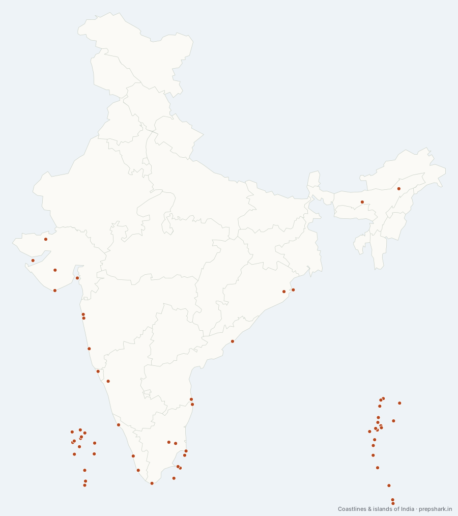
Numbered as on the map
The 62 on the map
1. Abdul Kalam Island
Odisha
Known forIndia’s missile test range
Formerly Wheeler Island, off the Odisha coast, and India’s missile test range — the Agni series has been launched from it since the 1990s. Renamed for Kalam in 2015, which links a piece of coastal geography to the missile programme he ran.
SettingOdisha coast · offshore island · test range
For the examFormerly Wheeler Island. The Agni missile tests are conducted from here.
2. Agatti
Lakshadweep
Known forLakshadweep’s only airport
The only island in Lakshadweep with an airstrip, and therefore the way in to the entire territory — everything and everyone arrives here or by ship. Its runway runs almost the full length of the island, which is a fair description of how narrow these atolls are.
SettingCoral atoll · airstrip · lagoon
3. Amini
Lakshadweep
Known forThe most densely populated Lakshadweep island
One of the northern Lakshadweep islands and the most densely populated of them, historically the seat of the island aristocracy and known for coir and cowrie. Its reef is one of the few in the group that has been continuously monitored for bleaching.
SettingCoral island · northern group · coir and cowrie
4. Androth
Lakshadweep
Known forThe largest Lakshadweep island, and the only one without a lagoon
The largest island in Lakshadweep by area and the closest to the mainland, and the only one of the group with no lagoon — it lies east to west where every other island lies north to south, and its reef sits tight against the shore. It is also the most orthodox and the first island of the group to convert to Islam.
SettingCoral island · no lagoon · east–west orientation
For the examLargest by area and the only Lakshadweep island without a lagoon. Minicoy is the southernmost.
5. Bangaram
Lakshadweep
Known forThe uninhabited atoll open to visitors
An uninhabited teardrop atoll near Agatti, the one island in the territory open to foreign tourists without the permit the inhabited islands require. That exception is the point: Lakshadweep’s entry restrictions are what have kept its reefs in the state they are.
SettingCoral atoll · uninhabited · lagoon
6. Baratang
Andaman and Nicobar Islands
Known forIndia’s only mud volcanoes
A small island between Middle and South Andaman holding the only mud volcanoes in India — cold vents pushing up methane and slurry rather than lava. It also has limestone caves and the largest mangrove creeks in the territory, reached only by boat through them.
SettingGreat Andaman · mud volcanoes · mangrove creeks
For the examMud volcanoes — cold methane vents, not igneous. Barren Island is the igneous one.
7. Barren Island
Andaman and Nicobar Islands
Known forThe only active volcano in India
The only confirmed active volcano in South Asia, an uninhabited cone in the Andaman Sea that has erupted repeatedly since 1991 after lying dormant for over a century. It sits on the same subduction arc as Sumatra, which is what the Andamans are — the tops of that arc.
SettingAndaman Sea · active stratovolcano · uninhabited
For the examThe only ACTIVE volcano in India. Narcondam nearby is dormant — the pair is the question.
8. Bitra
Lakshadweep
Known forThe smallest inhabited island in India
The smallest inhabited island in Lakshadweep and in India, a few hectares of land on a large reef, with a population in the low hundreds. It was uninhabited until the 1940s and is still the most isolated settlement in the territory.
SettingCoral atoll · few hectares of land · large reef
For the examSmallest inhabited island of Lakshadweep. Androth is the largest.
9. Car Nicobar
Andaman and Nicobar Islands
Known forThe Nicobars’ populous northern island
The northernmost and most populous of the Nicobars, flat and coral-fringed rather than hilly, and the group’s administrative centre. It was among the worst hit places in the 2004 tsunami: the air force station and much of the coastal settlement were destroyed.
SettingNicobar group · flat coral island · Nicobarese
10. Chetlat
Lakshadweep
Known forThe exposed island of the far north
One of the smallest inhabited islands of Lakshadweep, in the far north of the chain and among the most exposed — it has no proper lagoon on its western side, so the monsoon reaches the shore directly. That exposure is why its population has fallen where others have grown.
SettingCoral island · exposed western shore · northern group
11. Chorao
Goa
Known forGoa’s only bird sanctuary, in mangrove
The largest of the Mandovi islands, carrying the Dr Salim Ali bird sanctuary — Goa’s only bird sanctuary, and mangrove rather than forest. It is the counterpart to Divar beside it: the same estuary, one island farmed and one left to the mangrove.
SettingMandovi estuary · mangrove · Salim Ali sanctuary
12. Coco Channel
Andaman and Nicobar Islands
Known forThe strategic gap between India and Myanmar
The water separating the northernmost Indian island from the Coco Islands, which are Myanmar’s. It is the shortest maritime distance between India and Myanmar and sits astride the approaches to the Malacca Strait, which is why the reported activity on the Coco Islands is a recurring strategic story.
SettingChannel · Bay of Bengal · Malacca approaches
For the examThe Coco Islands belong to Myanmar, not India. Landfall Island is India’s northernmost point in the Bay of Bengal.
13. Coromandel Coast
Tamil Nadu
Known forThe coast fed by the retreating monsoon
The Tamil Nadu coast from the Krishna delta to Kanyakumari, and the one part of India that gets most of its rain from the retreating north-east monsoon rather than the south-west. That reversal is the single most examined fact about it, and it is why Chennai floods in November rather than July.
SettingDepositional coast · north-east monsoon rainfall · sand bars
For the examRain comes from the retreating (north-east) monsoon, October to December — the opposite of the rest of India.
14. Dhanushkodi
Tamil Nadu
Known forThe town destroyed by the 1964 cyclone
The sand spit at the eastern tip of Rameswaram, closest point in India to Sri Lanka, and a town destroyed in a single night by the 1964 Rameswaram cyclone — which took the pier, the train and about eighteen hundred people. It has been officially uninhabitable since.
SettingSand spit · Rama Setu approach · abandoned town
For the examDestroyed by the 1964 Rameswaram cyclone. It is the closest Indian land to Sri Lanka and the start of Rama Setu.
15. Diu
Dadra and Nagar Haveli and Daman and Diu
Known forThe Portuguese island off Saurashtra
An island off the southern tip of Saurashtra, Portuguese from 1535 until 1961, and the reason a union territory exists on a coast otherwise entirely Gujarati. Its fort commands the strait, which is what the Portuguese were there for: the Gujarat sea trade.
SettingSaurashtra coast · limestone island · Portuguese fort
16. Divar
Goa
Known forThe khazan tidal farmland of the Mandovi
A river island in the Mandovi estuary above Panaji, reached only by ferry, and one of the pieces of Goa that shows what the estuary was before the port. With Chorao beside it, it is the clearest surviving example of the khazan system — tidal fields reclaimed behind bunds and sluices, farmed for centuries.
SettingMandovi estuary · khazan tidal fields · river island
17. Duncan Passage
Andaman and Nicobar Islands
Known forThe strait inside the Andaman group
The strait between South Andaman with Rutland to its north and Little Andaman to its south — the gap inside the Andaman group, as distinct from the Ten Degree Channel which separates the groups. Confusing the two is the standard error.
SettingStrait · Andaman Sea · inter-island passage
For the examDuncan Passage is WITHIN the Andamans. The Ten Degree Channel separates the Andamans from the Nicobars.
18. Eight Degree Channel
Lakshadweep
Known forIndia’s maritime boundary with the Maldives
The water between Minicoy and Thuraakunu, the northernmost island of the Maldives — India’s maritime frontier in the Arabian Sea. Also called Maliku Kandu, after the Maldivian name for Minicoy, which is itself the clearest statement of how close the two are.
SettingDeep channel · Laccadive Sea · international boundary
For the examAlso called Maliku Kandu. It separates Minicoy from the Maldives; the Nine Degree separates Minicoy from Lakshadweep.
19. Elephanta Island
Maharashtra
Known forThe rock-cut Trimurti caves, a World Heritage site
An island in Mumbai harbour carrying rock-cut caves of the sixth century and the Trimurti sculpture, a World Heritage site. Its Portuguese name came from a stone elephant on the shore, which the British then tried to move and dropped in the sea.
SettingMumbai harbour · basalt island · rock-cut caves
20. Great Nicobar
Andaman and Nicobar Islands
Known forIndia’s southernmost island, and its biggest clearance controversy
The largest and southernmost Nicobar, carrying Indira Point, two national parks and a biosphere reserve, and home to the Shompen — among the most isolated peoples on earth. The Great Nicobar Development Project, with a transhipment port and an airport, is the largest environmental clearance controversy in India today.
SettingGreat Nicobar Biosphere Reserve · tropical evergreen · Shompen
For the examHolds Indira Point, Campbell Bay and Galathea national parks, and the Shompen and Nicobarese. 150 km from Sumatra.
21. Gulf of Khambhat
Gujarat
Known forThe gulf four major rivers empty into
The inlet east of Saurashtra into which the Narmada, Tapi, Mahi and Sabarmati all empty — four major rivers into one funnel, which is why its head silts so heavily that the ancient ports on it are now inland. Lothal, a Harappan dockyard, sits kilometres from the water it was built to use.
SettingMacrotidal gulf · heavy siltation · four river mouths
For the examThe Narmada, Tapi, Mahi and Sabarmati all drain into it. Lothal, the Harappan dock, is on its silted head.
22. Gulf of Kutch
Gujarat
Known forThe largest tidal range in India, and its first marine park
A funnel-shaped inlet between Kachchh and Saurashtra with among the largest tidal ranges in India — over eight metres at its head. That range is why it holds India’s first marine national park, why its corals are studied as a model for reefs under stress, and why tidal power has been proposed here since the 1980s.
SettingMacrotidal gulf · coral and mangrove · Kandla
For the examHighest tidal range in India. Kandla, a tidal port, is at its head; the Marine National Park is on its southern shore.
23. Gulf of Mannar
Tamil Nadu
Known forIndia’s only dugong population, and its first marine biosphere reserve
The water between the southern Tamil coast and Sri Lanka, separated from Palk Bay to the north by Rama Setu and Rameswaram. Its seagrass beds hold the only breeding dugong population left in India, and its chain of twenty-one islands is the first marine biosphere reserve in South Asia.
SettingCoral reef and seagrass · 21 islands · dugong
For the examGulf of Mannar is SOUTH of Rama Setu; Palk Bay is north. First marine biosphere reserve in South Asia.
24. Havelock Island
Andaman and Nicobar Islands
Known forSwaraj Dweep, the centre of Andaman tourism
Renamed Swaraj Dweep in 2018, along with Neil and Ross, to strip the colonial names — Havelock was a general of the 1857 suppression. It carries Radhanagar beach and is the centre of Andaman tourism, which is the pressure its reefs are under.
SettingRitchie’s Archipelago · coral reef · Radhanagar beach
For the examRenamed Swaraj Dweep in 2018. Neil became Shaheed Dweep and Ross became Netaji Subhas Chandra Bose Dweep.
25. Indira Point
Andaman and Nicobar Islands
Known forThe southernmost point of India
The southernmost point of India, on Great Nicobar, about 150 km from Sumatra. It subsided by several metres in the 2004 Sumatra earthquake and the lighthouse was partly submerged, which is why its recorded position is not the one on older maps.
SettingSouthern cape · Great Nicobar · subsided in 2004
For the examSouthernmost point of India, formerly Pygmalion Point. It sank several metres in the 2004 tsunami earthquake.
26. Kachchh Coast
Gujarat
Known forThe salt-flat coast where the Rann meets the sea
The northernmost stretch of the west coast, where the Rann meets the sea. It is the one piece of Indian coastline that is neither plain nor cliff but salt flat: the Great Rann floods each monsoon and dries to a crust, so the shoreline itself moves seasonally by tens of kilometres.
SettingRann of Kutch · saline flat · Gulf of Kutch
For the examEmergent coastline — the west coast north of Goa is emergent, the stretch south of it submergent. That pair is the question.
27. Kadmat
Lakshadweep
Known forThe long lagoon of the northern group
A long narrow island with one of the largest lagoons in the group, and the territory’s diving centre. Its shape is the standard atoll form of Lakshadweep — a sliver of land on the eastern rim of a reef, with the lagoon on the sheltered western side.
SettingCoral atoll · large lagoon · diving centre
28. Kalpeni
Lakshadweep
Known forThe coral storm bank thrown up in 1847
An island whose eastern shore carries a ridge of coral boulders thrown up by a storm in 1847 — a visible record of a single cyclone, still there. It is the clearest thing in the territory to a geological monument, and it is what a low coral island’s defence against the sea actually looks like.
SettingCoral atoll · storm-thrown boulder ridge · lagoon
29. Kanara Coast
Karnataka
Known forThe narrowest segment of the west coast plain
The middle segment of the west coast, from Goa to Mangaluru, and the narrowest — the Ghats come closest to the sea here, which is why the rivers are shortest and the rainfall highest. Karwar and New Mangalore are on it, and so is the Kali, the most heavily dammed river in the Ghats.
SettingSubmergent coast · laterite · Western Ghats scarp
30. Kanyakumari
Tamil Nadu
Known forThe southernmost point of mainland India
The southernmost point of mainland India, where the Arabian Sea, the Bay of Bengal and the Indian Ocean are said to meet. It is not the southernmost point of India — that is Indira Point in the Nicobars, six degrees further south — and the difference between the two is one of the most reliably asked facts in the subject.
SettingCape · three-sea confluence · Western Ghats terminus
For the examSouthernmost point of the MAINLAND. Indira Point, Great Nicobar, is the southernmost point of India.
31. Kathiawar Coast
Gujarat
Known forThe peninsular coast between two gulfs
The coast of the Saurashtra peninsula, between the two gulfs — Kutch to the north and Khambhat to the east. It is a raised, rocky, emergent shore, which is why Gujarat has the longest coastline of any Indian state and among the fewest natural deep-water harbours on it.
SettingSaurashtra · emergent rocky shore · Deccan basalt
For the examGujarat has the longest coastline of any Indian state, at roughly 1,600 km.
32. Kavaratti
Lakshadweep
Known forThe capital of Lakshadweep
The capital of Lakshadweep, and the administrative centre of the only coral atoll territory in India. The whole group is the exposed rim of a submerged volcanic ridge — the Chagos–Laccadive ridge — which is why every one of its islands is an atoll or a reef and none of them is more than a few metres above the sea.
SettingCoral atoll · Chagos–Laccadive ridge · lagoon
For the examIndia’s smallest union territory by area. All 36 islands are coral; only 10 are inhabited.
33. Kaveri Delta
Tamil Nadu
Known forThe granary of the south, and a sediment-starved delta
The rice country the Kallanai anicut made farmable in the second century, and the most intensively irrigated delta in South India. It is also sinking in the ordinary sense: the delta is starved of sediment by the dams upstream, so its shoreline is retreating while its water table is falling.
SettingKaveri delta · alluvial · Kallanai command
34. Kiltan
Lakshadweep
Known forThe island on the old Arab trade route
A northern Lakshadweep island that sat on the old Arab shipping route between the Malabar coast and the Gulf, and grew rich on it. It is the closest of the group to the mainland shipping lanes, which is the whole of its historical importance.
SettingCoral island · northern group · shallow lagoon
35. Konkan Coast
Maharashtra
Known forThe drowned-estuary coast between the Sahyadri and the sea
The west coast from Daman to Goa, a narrow strip between the Sahyadri and the sea, cut by short swift rivers into a succession of drowned estuaries. Those estuaries are the reason this stretch has natural harbours — Mumbai among them — where the coast further north has almost none.
SettingSubmergent coast · laterite cliffs · short west-flowing rivers
For the examKonkan (Daman to Goa), Kanara (Goa to Mangaluru), Malabar (Mangaluru to Kanyakumari) — the three names of the west coast plain, in order.
36. Landfall Island
Andaman and Nicobar Islands
Known forIndia’s northernmost island in the Bay of Bengal
The northernmost island of the Andaman group and therefore of India in the Bay of Bengal, separated from Myanmar’s Coco Islands by the Coco Channel. It is uninhabited and part of a sanctuary, which is why the strategic interest in it is about the water rather than the land.
SettingNorth Andaman group · uninhabited · sanctuary
37. Little Andaman
Andaman and Nicobar Islands
Known forThe Onge homeland, and a contested development plan
The southernmost island of the Andaman group, just north of the Ten Degree Channel, and the home of the Onge — one of the particularly vulnerable tribal groups, now numbering in the low hundreds. The 2021 NITI Aayog proposal to develop it as a tourism and shipping hub is the standing controversy.
SettingAndaman group · tropical evergreen · Onge reserve
38. Majuli
Assam
Known forThe largest river island in the world
The largest river island in the world, in the Brahmaputra, and shrinking fast — it has lost more than half its area to erosion since the early twentieth century. It is also the seat of the Vaishnavite satras founded by Srimanta Sankardeva, which is why its loss is a cultural question as well as a hydrological one.
SettingBrahmaputra · alluvial river island · rapid erosion
For the examLargest river island in the world, and India’s first island district. Umananda, downstream at Guwahati, is among the smallest inhabited ones.
39. Malabar Coast
Kerala
Known forThe backwater coast, from Mangaluru to Kanyakumari
The southern segment of the west coast, from Mangaluru to Kanyakumari, and the one with a landform found almost nowhere else in India: the backwaters, a chain of brackish lagoons held behind coastal sand bars and joined into a navigable system. Kerala’s settlement pattern follows them rather than the sea.
SettingSubmergent coast · backwater lagoons · sand bars
For the examThe kayals — Vembanad, Ashtamudi — are the defining feature. The coast is submergent, which is why the lagoons exist at all.
40. Middle Andaman
Andaman and Nicobar Islands
Known forThe island the Andaman Trunk Road crosses
The middle island of the Great Andaman chain, crossed by the Andaman Trunk Road — the road that runs through the Jarawa reserve and has been the subject of Supreme Court orders about contact with the Jarawa since 2002. The road, not the island, is what makes it a current-affairs answer.
SettingGreat Andaman · tropical evergreen · Jarawa reserve
For the examThe Andaman Trunk Road through the Jarawa reserve is the standing question about contact with a particularly vulnerable tribal group.
41. Minicoy
Lakshadweep
Known forThe Maldivian island of Lakshadweep
The southernmost island of Lakshadweep, cut off from the rest by the Nine Degree Channel and culturally Maldivian rather than Malayali: the language is Mahl, written in Thaana, and the tuna fishery and the boat-building follow Maldivian practice. It carries one of the oldest lighthouses in India.
SettingCoral atoll · Mahl-speaking · large lagoon
For the examThe language is Mahl (Dhivehi), not Malayalam. It lies between the Nine Degree and Eight Degree channels.
42. Munroe Island
Kerala
Known forThe sinking backwater islands of Kollam
A cluster of small islands where the Kallada river meets Ashtamudi lake, and one of the clearest Indian cases of land subsiding and salinity rising until a place becomes unliveable — houses have been abandoned to tidal flooding, and the cause is argued between the 2004 tsunami, dam releases and sand mining.
SettingAshtamudi · backwater islands · subsidence and salinity
43. Nancowry
Andaman and Nicobar Islands
Known forThe best natural harbour in the islands
The centre of the Nicobar group, whose sheltered harbour between Nancowry and Camorta is the best natural anchorage in the whole territory — the reason Danish, Austrian and British expeditions all tried to settle here in turn, and all failed to malaria.
SettingCentral Nicobars · natural harbour · tropical evergreen
44. Narcondam Island
Andaman and Nicobar Islands
Known forA dormant volcano, and the world’s only Narcondam hornbills
A dormant volcano in the Andaman Sea and the entire world range of the Narcondam hornbill — a bird found on this one island and nowhere else, in a population of a few hundred. A radar station proposed on it in 2012 was dropped for that reason.
SettingAndaman Sea · dormant volcano · single-island endemic
For the examDormant, not active — Barren Island is the active one. The Narcondam hornbill is endemic to this island alone.
45. Neil Island
Andaman and Nicobar Islands
Known forShaheed Dweep, and the Andamans’ vegetable garden
Renamed Shaheed Dweep in 2018, the smaller of the two visited islands of Ritchie’s Archipelago, and the vegetable garden of the Andamans — its flat coral-derived soil supplies Port Blair. The natural rock bridge on its eastern shore is its landmark.
SettingRitchie’s Archipelago · coral reef · flat coral soil
46. Nine Degree Channel
Lakshadweep
Known forThe channel that separates Minicoy from the rest of Lakshadweep
The gap separating Minicoy from the rest of Lakshadweep, at roughly nine degrees north. It matters because Minicoy is culturally Maldivian — the language is Mahl, not Malayalam — and the channel is why: it is the water barrier that kept the southernmost island apart from the others.
SettingDeep channel · Laccadive Sea · sea lane
For the examNine Degree Channel separates Minicoy from the main Lakshadweep group; the Eight Degree Channel separates Minicoy from the Maldives.
47. North Andaman
Andaman and Nicobar Islands
Known forThe northernmost Great Andaman island, and Saddle Peak
The largest and northernmost of the Great Andaman group, carrying Saddle Peak — the highest point of the whole archipelago — and Diglipur. It is the least developed of the three main islands and holds the largest continuous stretch of evergreen forest in the territory.
SettingGreat Andaman · tropical evergreen · Saddle Peak
48. North Sentinel Island
Andaman and Nicobar Islands
Known forThe Sentinelese, and India’s no-contact policy
The home of the Sentinelese, who have refused contact for as long as there is record of them and are protected by an exclusion zone that makes approaching the island an offence. They are the clearest case anywhere of a state choosing isolation as a protection policy rather than contact.
SettingAndaman group · tropical evergreen · exclusion zone
For the examA particularly vulnerable tribal group under a legally enforced exclusion zone. The island rose by a metre or more in the 2004 earthquake.
49. Northern Circars
Andhra Pradesh
Known forThe Andhra plain, and the Godavari and Krishna deltas
The northern Andhra coastal plain, between the Eastern Ghats and the Bay of Bengal, carrying the Godavari and Krishna deltas at its southern end. The name is colonial — the Circars were the districts the East India Company took from the Nizam — and it survives on maps for no better reason than that.
SettingDepositional coast · Godavari and Krishna deltas · Eastern Ghats scarp
50. Palk Strait
Tamil Nadu
Known forThe strait the Sethusamudram canal would have to cut
The shallow water between Tamil Nadu and Sri Lanka, too shallow for shipping — which is the whole reason the Sethusamudram canal has been proposed and abandoned repeatedly since 1860. Cutting it would shorten the passage around India by hundreds of nautical miles and would have to cut through Rama Setu.
SettingShallow strait · Rama Setu shoal · Palk Bay
For the examToo shallow for large ships. The Sethusamudram Ship Canal Project is the recurring proposal to dredge it.
51. Pamban Island
Tamil Nadu
Known forRameswaram’s island, and India’s first sea bridge
The island between the mainland and Sri Lanka that carries Rameswaram town, reached by the Pamban bridge — India’s first sea bridge, opened in 1914, and until recently its only rail link across open sea. The new vertical-lift bridge beside it is the first of its kind in the country.
SettingCoastal island · Gulf of Mannar · Palk Bay
52. Point Calimere
Tamil Nadu
Known forWhere the Coromandel coast turns into Palk Bay
The headland where the Coromandel coast turns west into Palk Bay, and the point at which the Kaveri delta ends. Its saltpans and mudflats hold one of the largest flamingo congregations on the east coast, which is why a geographical corner is also a Ramsar site.
SettingHeadland · saltpan and mudflat · Ramsar
53. Ross Island
Andaman and Nicobar Islands
Known forWhere Bose raised the flag in 1943
The British administrative headquarters of the Andamans until the 1941 earthquake wrecked it, opposite Port Blair, now ruins overgrown by fig roots. Renamed for Bose in 2018, because it is where he raised the tricolour in 1943 when the Japanese handed the islands to the Azad Hind government.
SettingPort Blair harbour · abandoned settlement · tropical forest
For the examRenamed Netaji Subhas Chandra Bose Dweep. Bose hoisted the tricolour here on 30 December 1943.
54. Salsette Island
Maharashtra
Known forThe island Mumbai stands on
The island Mumbai is built on, and the reason the city has the shape it does — seven islands joined by two centuries of reclamation into one. Sanjay Gandhi National Park and the Kanheri caves are on the same island, which is why a city of twenty million has leopards in it.
SettingKonkan · basalt island · reclaimed and joined
For the examThe seven islands of Bombay were joined by reclamation into Salsette. Sanjay Gandhi National Park is on it.
55. South Andaman
Andaman and Nicobar Islands
Known forPort Blair, and the Cellular Jail
The island that carries Port Blair and the Cellular Jail, and therefore the administrative and historical centre of the territory. The jail is where the Andamans enter Indian history properly: kala pani, the penal settlement built after 1857 and used for the revolutionaries of the freedom movement.
SettingGreat Andaman · tropical evergreen · Port Blair
For the examThe Cellular Jail — kala pani — is here. Ross Island opposite was the British administrative headquarters.
56. Sriharikota
Andhra Pradesh
Known forThe barrier island carrying India’s spaceport
The barrier island that separates Pulicat lagoon from the Bay of Bengal, and the site of the Satish Dhawan Space Centre. It is there for exactly the reason a barrier island exists — a long, empty spit of sand with open sea to the east, which is what a launch range needs.
SettingBarrier island · Pulicat lagoon · Coromandel coast
For the examSatish Dhawan Space Centre. Its eastern launch corridor over open ocean is why the site was chosen.
57. Srirangam
Tamil Nadu
Known forThe largest functioning temple complex in the world
A river island between the Kaveri and the Kollidam at Tiruchirappalli, carrying the Ranganathaswamy temple — the largest functioning temple complex in the world, with seven concentric walls. The island exists because the Kaveri splits at the Kallanai and rejoins downstream.
SettingKaveri delta head · river island · Kollidam divide
58. Suheli Par
Lakshadweep
Known forAn uninhabited turtle-nesting atoll
An uninhabited atoll in the south-west of Lakshadweep whose sandbanks are among the most important sea turtle nesting sites in the territory. It is the clearest example of what most of Lakshadweep actually is: reef and lagoon with barely any land at all.
SettingCoral atoll · uninhabited · turtle nesting
59. Ten Degree Channel
Andaman and Nicobar Islands
Known forThe gap that separates two different biotas
The hundred-and-fifty-kilometre gap that separates the Andaman group from the Nicobar group, and a biogeographic wall as much as a shipping lane: the Andamans’ species are Burmese and the Nicobars’ are Sumatran, and almost nothing crosses. It is also one of the busiest sea lanes in the Indian Ocean.
SettingDeep channel · biogeographic barrier · major sea lane
For the examSeparates the Andaman group from the Nicobar group, at roughly 10° N. Andaman species are Burmese, Nicobar species Sumatran.
60. Umananda Island
Assam
Known forAmong the smallest inhabited river islands in the world
A rock island in the Brahmaputra at Guwahati carrying a Shiva temple, and among the smallest inhabited river islands anywhere. It is the deliberate counterpart to Majuli upstream: the same river, the same process, at opposite extremes of scale.
SettingBrahmaputra · rock island · Guwahati
61. Utkal Plains
Odisha
Known forThe Odisha delta plain, and Chilika
The Odisha coastal plain, built by the Mahanadi, Brahmani and Baitarani where they meet the Bay of Bengal, and holding Chilika at its southern end. It is a depositional coast — sand bars, lagoons and deltas — which is exactly what makes it the most cyclone-exposed stretch of the Indian shore.
SettingDepositional coast · Mahanadi delta · cyclone landfall belt
For the examThe east coast plain in order from the north: Utkal, Northern Circars (Andhra), Coromandel (Tamil Nadu).
62. Willingdon Island
Kerala
Known forThe largest artificial island in India
The largest artificial island in India, dredged up out of Kochi’s backwaters in the 1930s to make a deep-water port — the spoil from the dredging became the land. It is the clearest Indian example of a port being manufactured rather than found.
SettingKochi backwaters · dredged land · deep-water port
Keep going