Geography · Atlas of India
Rivers of India
Landforms, water, climate, and the hazards they carry.
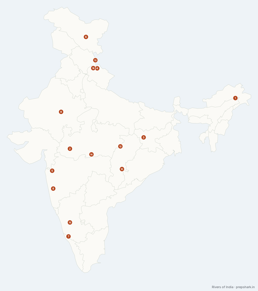
Numbered as on the map
The 16 on the map
1. Brahmaputra
Arunachal Pradesh
Known forThe Great Bend; the braided Assam channel
The Yarlung Tsangpo runs east across Tibet for well over a thousand kilometres, turns through the Great Bend at Namcha Barwa, and enters India as the Siang. At Sadiya the Dibang and Lohit join it and it becomes the Brahmaputra — a braided river carrying one of the world’s heaviest sediment loads across Assam.
SettingEastern Himalaya · braided alluvial channel · Majuli island
For the examThree names for one river — Tsangpo in Tibet, Siang/Dihang in Arunachal, Brahmaputra in Assam, Jamuna in Bangladesh. The sequence is what gets asked.
2. Chambal
Madhya Pradesh
Known forThe ravines; the gharial sanctuary
Rises in the Vindhyan scarp and runs north into the Yamuna through the badlands its own erosion cut. The ravines made the basin unfarmable and therefore unpopulated, which is why the cleanest large river in northern India — and the last serious gharial population — is here.
SettingVindhyan scarp source · badland ravines · Yamuna confluence
3. Damodar
Jharkhand
Known forThe Damodar Valley Corporation; the coal belt
The "sorrow of Bengal" until the Damodar Valley Corporation — India’s first multipurpose river valley project, modelled on the Tennessee Valley Authority — dammed it in 1948. It runs through the country’s densest coalfield, which is why it is also among its most polluted rivers.
SettingChhotanagpur plateau · coalfield · Hooghly confluence
For the examThe DVC is the first multipurpose project of independent India and the model for the rest. That is the fact, not the river.
4. Ganga
Uttarakhand
Known forIndia’s largest river basin, and the Bhagirathi–Alaknanda confluence
The Bhagirathi leaves the Gangotri glacier at Gaumukh and becomes the Ganga at Devprayag, where the Alaknanda joins it. Everything about the north Indian plain — its soil, its density, its politics — is downstream of this line, and the river drains about a quarter of India’s land area.
SettingHimalayan glacier source · alluvial plain · Ganga–Brahmaputra delta
For the examFive prayags on the Alaknanda, ending at Devprayag where the Ganga takes its name. The Bhagirathi is the headstream, not the Alaknanda — that is the question.
5. Godavari
Maharashtra
Known forThe longest peninsular river
The longest peninsular river — the "Dakshina Ganga" — rising fifty miles from the Arabian Sea at Trimbakeshwar and running fifteen hundred kilometres the other way to the Bay of Bengal. That asymmetry is the Western Ghats: the watershed sits at the western edge of the peninsula, so almost everything drains east.
SettingWestern Ghats source · Deccan plateau · Godavari delta
For the examLongest peninsular river; second longest in India after the Ganga. The Krishna is second among peninsular rivers.
6. Indus
Ladakh
Known forThe Indus Waters Treaty; the western rivers
Rises near Mansarovar in Tibet, enters India in Ladakh, and leaves again for Pakistan — so India controls a short middle reach of a river it gave its name to. The Indus Waters Treaty of 1960 allots this river and the Jhelum and Chenab to Pakistan, with limited Indian use.
SettingTrans-Himalayan cold desert · Ladakh range · Zanskar confluence
For the examWestern rivers (Indus, Jhelum, Chenab) to Pakistan; eastern rivers (Ravi, Beas, Sutlej) to India. Candidates reverse them.
7. Kaveri
Karnataka
Known forThe Grand Anicut; the Thanjavur delta
Rises at Talakaveri in Kodagu and reaches the sea through the Thanjavur delta — the oldest continuously irrigated landscape in India, watered by the Grand Anicut since the second century. The Karnataka–Tamil Nadu dispute is old because the irrigation is old.
SettingBrahmagiri source · Deccan · Cauvery delta · Hogenakkal falls
8. Krishna
Maharashtra
Known forThe second longest peninsular river; a four-state basin
Rises at Mahabaleshwar and crosses the peninsula through Karnataka and the Nallamala gorge into the Andhra delta. Its interstate allocation — Maharashtra, Karnataka, Telangana, Andhra Pradesh — has been before water disputes tribunals for longer than any other Indian river.
SettingWestern Ghats source · Deccan plateau · Nallamala gorge · delta
9. Luni
Rajasthan
Known forThe only major river of the Thar; inland drainage
Rises in the Aravallis and dies in the Rann of Kachchh without reaching the sea — the only substantial river of the Thar, and the classic Indian example of inland drainage. It turns saline halfway down, which is where the name comes from.
SettingAravalli source · Thar desert · Rann of Kachchh terminus
For the examInland drainage is the category — Luni, Ghaggar, and the Sambhar basin. A river that does not reach the sea is the point.
10. Mahanadi
Chhattisgarh
Known forThe Hirakud dam; the Odisha delta
Rises in the Dandakaranya highlands and cuts through the Eastern Ghats to build the Odisha delta and feed Chilika’s hinterland. The Hirakud dam on it is the longest earthen dam in the world and was built as a flood-control answer to this river’s discharge.
SettingDandakaranya source · Eastern Ghats gorge · Mahanadi delta
11. Narmada
Madhya Pradesh
Known forThe largest west-flowing river; a rift valley course
Rises at Amarkantak and runs west through a rift valley between the Vindhyas and the Satpuras into the Gulf of Khambhat — one of only three major Indian rivers flowing west, and the reason it builds an estuary rather than a delta.
SettingMaikal hills source · Narmada–Son rift · Gulf of Khambhat estuary
For the examWest-flowing and therefore estuarine, not deltaic. The three west-flowing rivers are the Narmada, the Tapi and the Mahi.
12. Son
Madhya Pradesh
Known forThe Ganga’s largest southern tributary; the Narmada’s twin source
Rises on the same hill as the Narmada and runs the opposite way — north-east along the rift to join the Ganga near Patna. Two rivers from one watershed draining to two different seas is the single most teachable fact in Indian physical geography, and it is a fact you can only see on a map.
SettingMaikal hills source · Son–Narmada rift · Ganga confluence
For the examAmarkantak is the source of both the Narmada and the Son. Questions offer one and expect you to miss the other.
13. Sutlej
Himachal Pradesh
Known forAn antecedent river; the Bhakra dam
The longest of the five Punjab rivers, rising at Rakshastal in Tibet and entering India through Shipki La. It is an antecedent river — older than the Himalaya it cuts through — which is why it runs in a gorge across the grain of the range rather than around it.
SettingTrans-Himalayan gorge · Kinnaur · Punjab plain
For the examThe three antecedent rivers of the Himalaya are the Indus, the Sutlej and the Brahmaputra. That triple is the question.
14. Tapi
Madhya Pradesh
Known forThe second major west-flowing river
The second west-flowing river, rising at Multai on the Satpura crest and running parallel to the Narmada into the Gulf of Khambhat. The valley between the two carries the whole east–west road and rail spine of central India.
SettingSatpura source · rift valley · Gulf of Khambhat estuary
15. Tungabhadra
Karnataka
Known forThe Krishna’s largest tributary; Hampi sits on it
Formed where the Tunga and the Bhadra join at Koodli, and the Krishna’s largest tributary. Vijayanagara was built on its south bank because the river was the defensible line — the ruins at Hampi sit on it.
SettingWestern Ghats headwaters · Deccan granite · Hampi gorge
16. Yamuna
Uttarakhand
Known forThe Ganga’s longest tributary; the doab it makes
The Ganga’s longest tributary, rising at Yamunotri and running parallel to it for a thousand kilometres before joining at Prayagraj. That parallel reach is the Ganga–Yamuna doab, the most intensively farmed and most densely settled land in the country.
SettingBandarpunch glacier source · doab alluvium · Chambal confluence
Keep going