Geography · Atlas of India
Passes & gaps of India
Landforms, water, climate, and the hazards they carry.
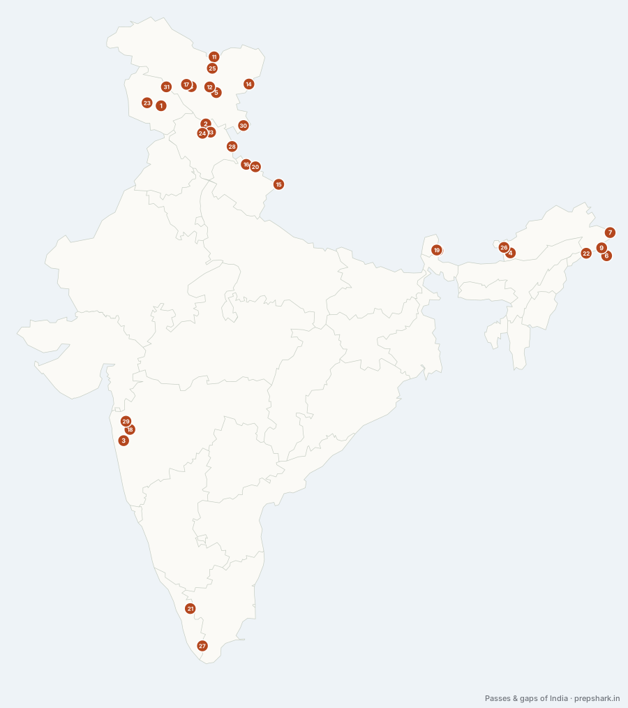
Numbered as on the map
The 31 on the map
1. Banihal Pass
Jammu and Kashmir
Known forThe Jammu–Srinagar crossing, and the Jawahar Tunnel
The Pir Panjal crossing that carries the road from Jammu into the Kashmir valley, and the reason the valley was reachable in winter at all once the Jawahar Tunnel was driven under it in 1956. The rail tunnel beneath it is now the longest in India, which is the same problem answered twice in a century.
SettingPir Panjal crest · 2,832 m · snow-closed before the tunnel
For the examThe Jawahar Tunnel (1956) runs under it; the Banihal–Qazigund rail tunnel is the longest railway tunnel in India.
2. Baralacha La
Himachal Pradesh
Known forThe three-valley junction on the Manali–Leh road
A pass on the Zanskar range where three valleys meet — Lahaul, Ladakh and Spiti — and the watershed between the Chandra and the Bhaga, the two streams that unite to make the Chenab. Suraj Tal, one of the highest lakes in India, lies just below it.
SettingZanskar range · 4,890 m · Chandra and Bhaga watershed
3. Bhor Ghat
Maharashtra
Known forThe Mumbai–Pune crossing of the Sahyadri
The southern of the two great Sahyadri passes, carrying the road and rail from Mumbai to Pune, and the harder of the two to build — the 1863 railway incline through it cost thousands of lives and is still one of the steepest worked gradients in India.
SettingSahyadri scarp · 550 m · Khandala incline
4. Bomdi La
Arunachal Pradesh
Known forThe 1962 position below Sela
The pass on the road south from Sela towards the Assam plain, and the second position lost in 1962 — after it fell the road to Tezpur was open, which is the moment the war is usually said to have been decided. It is also the western limit of the eastern Himalayan bird belt.
SettingEastern Himalaya · 2,415 m · Kameng valley
5. Chang La
Ladakh
Known forThe road to Pangong Tso
The pass on the Ladakh range that the road to Pangong Tso crosses, and among the highest motorable passes anywhere. It is the land approach to the lake whose northern bank has featured in every India–China standoff since 2020.
SettingLadakh range · 5,360 m · Changthang approach
6. Chaukan Pass
Arunachal Pradesh
Known forThe 1942 refugee route out of Burma
A pass on the Patkai in the far east of Arunachal, and the route thousands of refugees walked out of Burma in 1942 when the Japanese advance cut the other roads. It is among the wettest and least accessible crossings on the whole Indian frontier.
SettingPatkai range · 2,000 m · Namdapha catchment
7. Diphu Pass
Arunachal Pradesh
Known forThe India–China–Myanmar trijunction
The pass at the eastern end of the Himalaya where India, China and Myanmar meet, and one of the points at which India and China describe the boundary differently. It is the easternmost pass on the Indian claim line and it appears in every question about that trijunction.
SettingEastern Himalaya · 4,587 m · Dibang and Lohit head
For the examThe trijunction of India, China and Myanmar. India and China place the boundary here differently.
8. Fotu La
Ladakh
Known forThe highest point of the Srinagar–Leh highway
The highest point on the Srinagar–Leh highway, on the Zanskar range between Kargil and Lamayuru. Zoji La is the famous one on that road and Fotu La is the high one, which is the distinction the question usually turns on.
SettingZanskar range · 4,108 m · Lamayuru approach
For the examHigher than Zoji La, which is the gateway pass on the same road. Namika La is the third on that stretch.
9. Hpungan Pass
Arunachal Pradesh
Known forAn eastern crossing of the Indo-Myanmar frontier
A pass on the Patkai range at the Myanmar border, north of Chaukan, in the block of forest that Namdapha protects. It completes the set of eastern crossings a question about the Indo-Myanmar frontier asks for and is the one most often left out.
SettingPatkai range · Indo-Myanmar border · Namdapha catchment
10. Jelep La
Sikkim
Known forThe old Lhasa trade route, closed since 1962
The pass on the Sikkim–Tibet border that carried the main trade route to Lhasa before 1962, through the Chumbi valley — Younghusband’s expedition of 1904 went this way. It has stayed closed since the war while Nathu La beside it reopened, which is the contrast the two are asked about.
SettingEastern Himalaya · 4,267 m · Chumbi valley
For the examJelep La is closed; Nathu La beside it reopened for border trade in 2006.
11. Karakoram Pass
Ladakh
Known forThe pass the range is named after, on the old Yarkand road
The pass that gives the Karakoram its name, on the watershed between the Indus and the Tarim, and for centuries the crossing on the caravan road from Leh to Yarkand. It is now closed and sits on the Line of Actual Control, which is why it is a boundary question as much as a trade one.
SettingKarakoram crest · 5,540 m · Indus–Tarim watershed
For the examThe Karakoram Pass, the Karakoram range and the Karakoram Highway are three different things in three different places.
12. Khardung La
Ladakh
Known forThe Leh–Nubra crossing, and a famous overstated claim
The pass on the Ladakh range carrying the road from Leh into the Nubra valley, and the gateway to the Siachen approach. It is signposted as the highest motorable road in the world, which it is not — the sign overstates its height by several hundred metres and Umling La is higher — but the claim is examined as often as the geography.
SettingLadakh range · 5,359 m · Nubra approach
For the examNot the highest motorable pass — Umling La is. The roadside sign is wrong and the question turns on knowing that.
13. Kunzum Pass
Himachal Pradesh
Known forThe gateway into Spiti, and the monsoon’s limit
The pass over the Kunzum range that joins Lahaul to Spiti, and the way into the Spiti valley from the west. Chandra Taal lies a short walk from it, and the pass is the point at which the monsoon finally stops: south of it is wet, north of it is cold desert.
SettingKunzum range · 4,590 m · monsoon boundary
14. Lanak La
Ladakh
Known forA disputed pass on the Aksai Chin line
A pass on the eastern edge of Ladakh in territory India claims and China administers, and one of the points at which the two sides describe the boundary differently. It matters as a boundary fact rather than as a road: nobody crosses it, and both governments cite it.
SettingAksai Chin · 5,466 m · disputed boundary
For the examIn territory claimed by India and administered by China. The Indian and Chinese descriptions of the boundary differ here.
15. Lipulekh Pass
Uttarakhand
Known forA border trade point, and a three-way territorial dispute
The third of the designated India–China border trade points and the traditional route of the Kailash Mansarovar pilgrimage. It is also claimed by Nepal, which issued a map in 2020 showing Kalapani and Lipulekh as Nepali territory — the one pass in this list that is disputed with two neighbours at once.
SettingKumaon Himalaya · 5,115 m · Kailash route
For the examThe three designated India–China trade points are Nathu La, Shipki La and this one. Nepal disputes the Kalapani–Lipulekh area.
16. Mana Pass
Uttarakhand
Known forThe pass above Badrinath, on the old Tibet road
The pass above Badrinath on the Tibet border, one of the highest vehicle-accessible passes in the world and the old pilgrim and trade route into western Tibet. Mana village below it is billed as the last village in India, which since the Vibrant Villages programme is a phrase the government has been at pains to reverse.
SettingGarhwal Himalaya · 5,610 m · Saraswati valley
17. Namika La
Ladakh
Known forThe middle pass on the Srinagar–Leh road
The middle of the three passes on the Srinagar–Leh road, between Zoji La and Fotu La, in the Zanskar range. Its name means the pillar of the sky, and it completes the set a question about that highway usually asks for in order.
SettingZanskar range · 3,700 m · Kargil approach
18. Naneghat
Maharashtra
Known forThe Satavahana toll road over the Ghats
An ancient pass through the Sahyadri on the trade route from the Konkan ports up to Junnar, with Satavahana inscriptions cut into the rock beside it and a stone toll jar at the top — the name means toll pass. It is the oldest documented crossing of the Ghats.
SettingSahyadri · ancient trade route · Satavahana inscriptions
19. Nathu La
Sikkim
Known forIndia–China border trade; the old Lhasa route
One of the few open trading posts on the India–China border, on the old Lhasa caravan route out of Kalimpong. Closed after 1962 and reopened for border trade in 2006, which is why it appears in every question about India–China confidence-building.
SettingEastern Himalaya · 4,310 m · Chumbi valley approach
For the examThree border-trade points with China: Nathu La (Sikkim), Shipki La (Himachal), Lipulekh (Uttarakhand). The triple is the question.
20. Niti Pass
Uttarakhand
Known forThe Garhwal trade route closed in 1962
The other Garhwal pass into Tibet, at the head of the Dhauliganga above Joshimath, and the trade route the Bhotiya communities used until 1962 closed it. Its closure is the reason a whole trading economy in the upper Alaknanda simply ended.
SettingGarhwal Himalaya · 5,070 m · Dhauliganga head
21. Palghat gap
Kerala
Known forThe only major break in the Western Ghats
A thirty-kilometre break in the Western Ghats between the Nilgiris and the Anaimalais — the only substantial one — and therefore the road, the rail line and the monsoon’s way into the Tamil interior. It is also a biogeographic barrier: species either side of it diverged.
SettingStructural gap · rain-shadow corridor · Bharathappuzha
For the examPalghat is the gap; Bhor Ghat and Thal Ghat are passes further north. The Shencottah gap is the small southern one.
22. Pangsau Pass
Arunachal Pradesh
Known forThe Stilwell Road crossing into Myanmar
The pass on the Patkai range into Myanmar that the Stilwell Road was driven through in 1942 to supply China after Burma fell — built by American engineers and Indian labour at a cost that gave it the name Hell Pass. Reopening it as a trade route is a recurring proposal.
SettingPatkai range · 1,136 m · Indo-Myanmar border
For the examThe Stilwell (Ledo) Road ran from Ledo in Assam through here to Kunming. Reopening it is a standing proposal.
23. Pir Panjal Pass
Jammu and Kashmir
Known forThe Mughal route into Kashmir
The pass the Mughal emperors crossed to reach Kashmir, on the road from Bhimber to Srinagar that Akbar had built and Jahangir died returning along. It is the historical route the Banihal road replaced, and the modern Mughal Road follows part of it.
SettingPir Panjal crest · 3,490 m · Mughal Road
24. Rohtang Pass
Himachal Pradesh
Known forThe Kullu–Lahaul crossing; the Atal Tunnel
The crossing from the Kullu valley into Lahaul and Spiti over the Pir Panjal, and the climatic boundary that comes with it: monsoon forest on the south side, cold desert on the north. The Atal Tunnel beneath it made Lahaul reachable in winter for the first time in 2020.
SettingPir Panjal crest · 3,978 m · monsoon-to-cold-desert transition
25. Saser La
Ladakh
Known forThe glacier crossing on the old caravan road
The pass over the Saser Muztagh between the Nubra and the Shyok, and the hardest stage of the old Leh–Yarkand caravan road — the crossing is a glacier, and the bones of pack animals marked it for a century. It sits below Saser Kangri, the highest peak of the sub-range.
SettingSaser Muztagh · 5,411 m · glacier crossing
26. Sela Pass
Arunachal Pradesh
Known forThe road to Tawang, and a 1962 battle
The pass that carries the only road to Tawang, and the position the Indian army held and lost in the 1962 war — its fall opened the road to Bomdila. The Sela tunnel beneath it, opened in 2024, is what finally made Tawang reachable in winter.
SettingEastern Himalaya · 4,170 m · Tawang approach
For the examThe Sela tunnel opened in 2024. The 1962 fighting here and at Bomdila is the standard pairing.
27. Shencottah Gap
Tamil Nadu
Known forThe second gap in the Western Ghats
The second break in the Western Ghats after Palghat, about ten kilometres wide, carrying the road and rail line from Madurai to Kollam. It is the southern gap the question pairs with Palghat, and like it, it is a biogeographic divide as much as a route.
SettingWestern Ghats · structural gap · Madurai–Kollam route
For the examAlso written Senkotta, Sengottai or Shenkottai after the town at its mouth — the same gap under four spellings. Palghat is the large gap and this is the small southern one; the pair is the question.
28. Shipki La
Himachal Pradesh
Known forThe Sutlej’s entry; a border trade point
The Sutlej’s doorway into India and one of the three designated border-trade points with China. A pass that a major antecedent river runs through is unusual: the river is older than the mountains, so it kept its course while the range rose around it.
SettingTrans-Himalaya · 3,930 m · Kinnaur cold desert
29. Thal Ghat
Maharashtra
Known forThe Mumbai–Nashik crossing of the Sahyadri
Also called Kasara Ghat, the northern of the two great Sahyadri passes, carrying the road and rail from Mumbai to Nashik and the north. With Bhor Ghat it is the pair that made Bombay a port for the Deccan rather than only for the coast.
SettingSahyadri scarp · 583 m · Kasara
For the examThal Ghat goes to Nashik and the north; Bhor Ghat goes to Pune and the south-east. The pair is the question.
30. Umling La
Ladakh
Known forThe highest motorable road in the world
The highest motorable road in the world, built by the Border Roads Organisation and opened in 2021 at over 5,700 metres — higher than Everest base camp. It is in the Chumar sector near the Line of Actual Control, which is why a road record is also a strategic one.
SettingEastern Ladakh · 5,798 m · Chumar sector
For the examOpened 2021 by the BRO. It, not Khardung La, holds the highest-motorable-road record.
31. Zoji La
Ladakh
Known forThe Srinagar–Leh road; the Zojila tunnel
The Great Himalaya’s gate into Ladakh, and the single point on which the Srinagar–Leh road depends. It closes with the first heavy snow and is the reason the Zojila tunnel — when it opens, the longest in Asia — is a strategic project rather than a convenience.
SettingGreat Himalaya crest · 3,528 m · snow-closed in winter
Keep going