Geography · Atlas of India
Rainfall regions of India
Landforms, water, climate, and the hazards they carry.
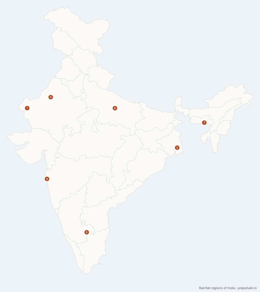
Numbered as on the map
The 7 on the map
1. 0–20 cm
Rajasthan
Known forThe driest class: the western Thar, and the trans-Himalaya
The two places in India where a whole monsoon delivers less than twenty centimetres, and they are dry for opposite reasons. The western Thar lies parallel to the Arabian Sea branch of the monsoon rather than across it, so the moist air runs up the coast without being lifted; Ladakh and the upper Indus valley sit behind the whole Himalaya, which has already wrung the air out before it can arrive.
SettingArid · western Thar and the trans-Himalayan valleys · under 20 cm in the season · pinned at Sam
For the examTwo mechanisms, one class: the Thar is dry because the wind runs parallel to it, Ladakh because it is a rain shadow.
2. 100–200 cm
West Bengal
Known forThe wet quarter: the delta, the east coast and the north-east
The wet quarter of the country: the lower Ganga plain and the delta, Odisha and the eastern coastal plain, the Chotanagpur and Satpura hills, the north-eastern valleys, and the coastal strip below the Ghats. The Bay of Bengal branch of the monsoon does most of this, sweeping up the delta and turning north-west along the Himalayan front — which is why the isohyets in the north run parallel to the mountains rather than to the coast.
SettingHumid · lower Ganga plain, the east coast and the north-eastern valleys · 100 to 200 cm · pinned at Kolkata
For the examThe Bay branch turns north-west up the plain, so rainfall falls off westward along the Ganga — Kolkata to Patna to Delhi is the sequence to quote.
3. 20–40 cm
Rajasthan
Known forThe desert margin, where the rain is unreliable rather than absent
The apron around the driest core — eastern Rajasthan into Haryana and Punjab, the Kachchh peninsula, and the Kashmir valley behind the Pir Panjal. This is the band where rainfall becomes unreliable rather than merely low: the season’s total varies more from year to year here than anywhere else in the country, which is what makes the tract famine country in the record and canal country on the map.
SettingSemi-arid · eastern Thar, Kachchh, the Kashmir valley · 20 to 40 cm · pinned at Bikaner
4. 200–400 cm
Maharashtra
Known forThe windward Ghats, the Duars and the north-eastern hills
A narrow strip along the windward face of the Western Ghats from Gujarat to Kerala, the hills of the north-east, and the sub-Himalayan Duars. All of it is orographic: the monsoon meets a wall, is forced up, cools, and unloads. The Konkan strip is only fifty to eighty kilometres wide, which is why this class covers so little of the country while producing so much of its water.
SettingVery humid · the windward Ghats, the Duars and the north-east · 200 to 400 cm · pinned at Mumbai
For the examOrographic rainfall: the same air gives this class on the windward side and the 40–60 class in the lee.
5. 40–60 cm
Karnataka
Known forThe peninsular rain shadow, and the plains of the north-west
Two separate dry belts share this class. One runs from Haryana down through eastern Rajasthan into Malwa; the other is the interior of the peninsula — the Karnataka maidan, Rayalaseema and the Tamil Nadu interior — which sits in the rain shadow of the Western Ghats and gets the leavings of air that has already dropped two metres of rain thirty kilometres to its west.
SettingDry sub-humid · the Deccan lee and the north-western plains · 40 to 60 cm · pinned at Bengaluru
For the examThe rain shadow is the point: the wettest and one of the driest classes are within fifty kilometres of each other across the Ghats.
6. 60–100 cm
Uttar Pradesh
Known forThe largest class, and where wheat country becomes rice country
The largest class on the map, and the one most of India lives in: the middle Ganga plain, the Gujarat plain, the greater part of the Deccan, and the eastern Tamil Nadu coast. Sixty centimetres is roughly where unirrigated wheat becomes possible and a hundred is where rice takes over without a canal, so this band is where the country’s two staple crops change places.
SettingSub-humid · the middle Ganga plain and much of the Deccan · 60 to 100 cm · pinned at Lucknow
7. Above 400 cm
Meghalaya
Known forThe wettest class: the Khasi hills and the Ghat crest
The smallest class, and almost all of it is two places: the southern face of the Khasi and Garo hills, and the crest of the Western Ghats between Goa and the Nilgiris. At Mawsynram the Bay branch is funnelled up a shallow, wedge-shaped valley and lifted against a scarp in one step, which is the mechanism behind the highest rainfall recorded anywhere on earth.
SettingTorrential · the southern Meghalaya scarp and the Ghat crest · above 400 cm · pinned at Mawsynram
For the examMawsynram and Cherrapunji are eleven kilometres apart and are asked interchangeably; a funnelled valley and a scarp in one step is the reason for both.
Keep going