Geography · Atlas of India
Mountain ranges of India
Landforms, water, climate, and the hazards they carry.
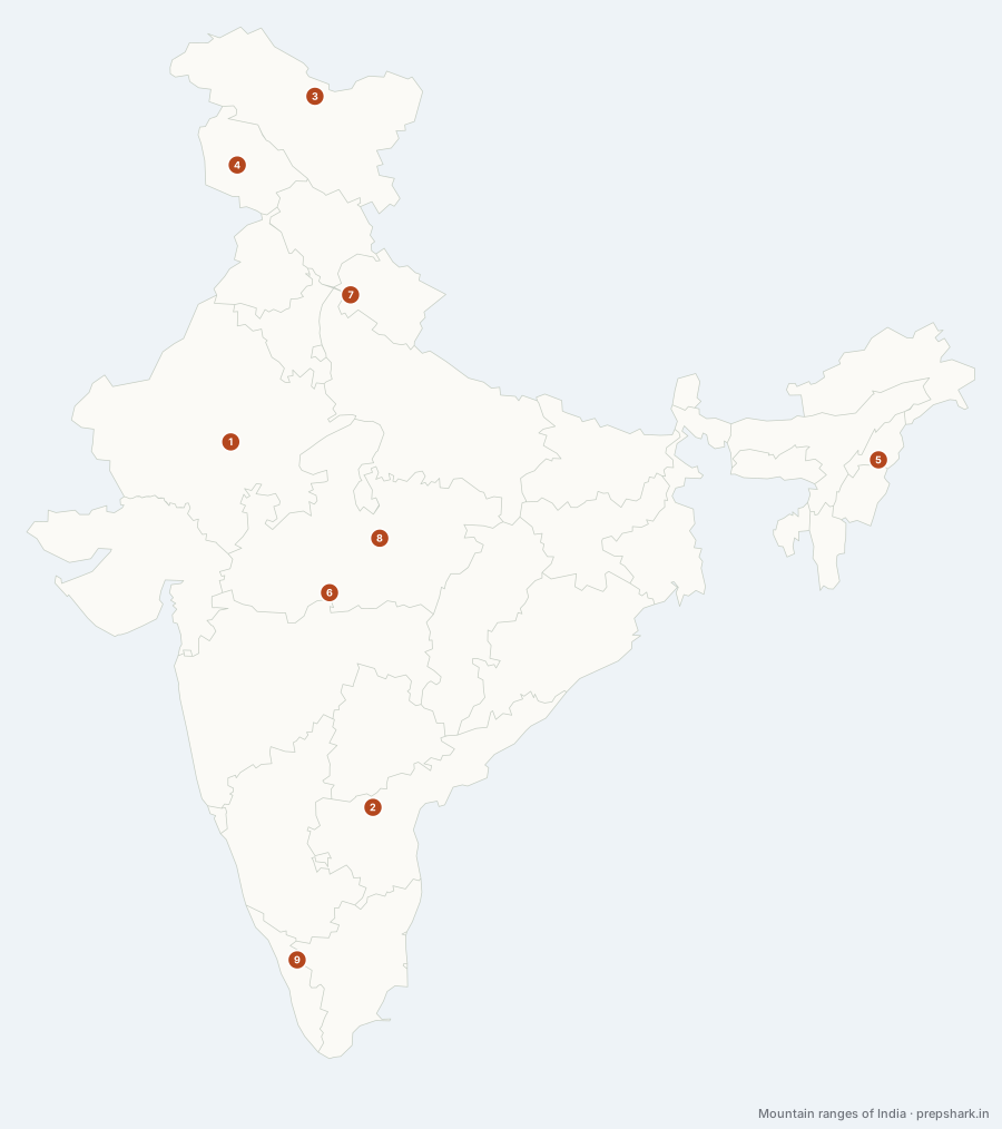
Numbered as on the map
The 9 on the map
1. Aravalli
Rajasthan
Known forThe oldest fold mountains in India; Guru Shikhar
The oldest fold mountain system in India and among the oldest on earth, worn down from an alpine range to a ridge line running north-east from Gujarat to Delhi. It is the barrier that stops the Thar spreading east, which is why deforestation along it is a desertification question rather than a forestry one.
SettingPrecambrian fold belt · dry deciduous and thorn · Luni source
For the examGuru Shikhar (1,722 m) at Mount Abu. The range ends at the Delhi ridge — that northern terminus gets asked.
2. Eastern Ghats
Andhra Pradesh
Known forA broken range, cut by every east-flowing river
Discontinuous where the Western Ghats are unbroken, because every major east-flowing river has cut through them — the Mahanadi, the Godavari, the Krishna and the Kaveri all breach the range. That is why they are lower, drier and far less endemic than the western wall.
SettingDiscontinuous hill belt · dry deciduous · bauxite-bearing
3. Karakoram
Ladakh
Known forSiachen; the largest non-polar glaciers
The northernmost range under Indian administration, holding the largest glaciers outside the poles — Siachen alone is seventy kilometres long. It is not part of the Himalaya proper: the Karakoram is a separate system north of the Indus, which is why the Indus runs between the two.
SettingTrans-Himalayan · glaciated · cold desert
For the examThe Karakoram Pass, the range and the Karakoram Highway are three different things in three different places. Questions mix them.
4. Pir Panjal
Jammu and Kashmir
Known forThe southern wall of the Kashmir valley
The longest range of the Lesser Himalaya, and the wall that makes the Kashmir valley a valley — it holds the monsoon out and the Jhelum in. Every road and rail line into Kashmir crosses it, at Banihal, which is why the Jawahar and Banihal tunnels exist.
SettingLesser Himalaya · Jhelum catchment · alpine meadow (margs)
5. Purvanchal hills
Nagaland
Known forThe eastern hills; the Myanmar border ranges
Where the Himalaya turns south at the Namcha Barwa syntaxis and runs down the Myanmar border as the Patkai, Naga, Manipur and Mizo hills. They are the same orogeny seen end-on, which is why they are low, wet and forested where the main arc is high and dry.
SettingEastern Himalaya syntaxis · tropical evergreen · high rainfall
6. Satpura
Madhya Pradesh
Known forThe Narmada–Tapi divide; Dhupgarh
The south wall of the Narmada rift and the watershed between the Narmada and the Tapi. Basaltic where the Vindhyas are sandstone, and therefore higher, wetter and forested — which is why the country’s tiger heartland is on this side of the valley and not the other.
SettingDeccan basalt highland · moist deciduous · Denwa and Tawa
For the examNarmada to the north of the Satpuras, Tapi to the south, both running west. The range between them is the divide.
7. Shivalik
Uttarakhand
Known forThe outer Himalaya; the duns behind it
The outermost and youngest Himalayan band, built of the range’s own eroded debris. Being unconsolidated sediment makes it the most landslide-prone terrain in the country, and the flat-floored duns behind it — Dehradun, Patli Dun — are the only farmland in the foothills.
SettingOuter Himalaya · unconsolidated sediment · sal forest · Bhabar
For the examShivalik → dun → Lesser Himalaya, south to north. The dun is between the ranges, not in front of them.
8. Vindhya
Madhya Pradesh
Known forThe north–south divide; the Narmada’s north wall
Not a fold range but an escarpment — the north wall of the Narmada rift, made of flat-lying Vindhyan sandstone. It is the traditional line between north and south India, and it is a cultural boundary precisely because it was a physical one before the railways.
SettingVindhyan sandstone escarpment · dry deciduous · Son and Chambal heads
9. Western Ghats
Kerala
Known forA UNESCO World Heritage biodiversity hotspot; Anamudi
The uplifted edge of the Deccan plateau rather than a fold range, running unbroken for 1,600 km and intercepting the entire south-west monsoon. Everything downstream of that interception — the peninsula’s east-flowing rivers, the rain shadow of the Deccan, the coffee and cardamom belts — is a consequence of this one wall.
SettingDeccan escarpment · evergreen shola and grassland · monsoon barrier
For the examAnamudi (2,695 m) is the highest peak in peninsular India, in the Anaimalai hills. Doddabetta in the Nilgiris is the distractor.
Keep going