Geography · Atlas of India
Plateaus & deserts of India
Landforms, water, climate, and the hazards they carry.
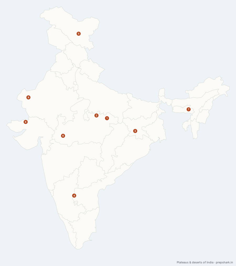
Numbered as on the map
The 9 on the map
1. Baghelkhand Plateau
Madhya Pradesh
Known forThe Son rift, and the Gondwana coal south of it
Vindhyan sandstone laid flat over the old shield, standing 300 to 600 metres and cut clean in two by the Son running north-east along a rift. North of the river the Kaimur scarp carries the Vindhyan wall towards the Ganga; south of it lie the Gondwana basins, which is why the Sohagpur and Umaria coalfields are here and not in Bundelkhand next door.
SettingVindhyan sandstone · Gondwana coal measures · Son and Rihand · Kaimur scarp
For the examGondwana coal is the distinction to hold: it sits in the rift basins along the Son and the Damodar, not in the Vindhyan sandstone above them, and about ninety-nine per cent of India’s coal is Gondwana rather than Tertiary.
2. Bundelkhand Upland
Madhya Pradesh
Known forArchaean granite, chronic drought, and Panna’s diamonds
The oldest rock on this layer and the lowest ground on it: a granite and gneiss peneplain of the Bundelkhand craton, worn down to 150–450 metres and studded with bare tors. It spans the Madhya Pradesh–Uttar Pradesh boundary between the Yamuna and the Vindhyan scarp, and the thin soil over hard rock is why the region’s droughts are a chronic policy problem rather than a weather event.
SettingBundelkhand granite · thin soil over tors · Betwa, Dhasan and Ken · drought-prone
For the examPanna’s diamonds come from kimberlite pipes at the Vindhyan edge of this upland — the only working diamond field in India, and the reason the region turns up in mineral questions as well as drought ones.
3. Chotanagpur Plateau
Jharkhand
Known forIndia’s mineral core; the Damodar coalfields
The north-eastern limb of the peninsular block, standing at 600 to 700 metres over a plain at under a hundred — which is why its edge is the sharpest line on this layer and why the Subarnarekha and the Damodar leave it in gorges. The Damodar crosses it along a rift filled with Gondwana coal; the country’s densest coalfield, its iron ore and its mica belt are all consequences of one plateau having been faulted, flooded and left alone since.
SettingArchaean gneiss with Gondwana rift basins · pat highlands · Damodar and Subarnarekha
For the examJharia, Bokaro and Karanpura sit in the Damodar rift; Koderma is mica; the Rajmahal traps close the plateau’s north-eastern end and are the same lava as the Deccan’s, erupted at the other end of the same event.
4. Deccan Plateau
Andhra Pradesh
Known forThe eastward tilt that sends the peninsula’s rivers to the Bay
The triangular block that is most of the peninsula — basalt trap north-west of a line through Nashik and Nagpur, Archaean gneiss and granite south of it — walled by the Satpura, the Western Ghats and the Eastern Ghats. It tilts EAST, and that single fact explains the Godavari, the Krishna and the Kaveri reaching the Bay of Bengal after rising within eighty kilometres of the Arabian Sea.
SettingDeccan trap and Archaean gneiss · black soil in the north-west · rain-shadow interior
For the examIt is taught in three parts — the Maharashtra plateau on the traps, the Karnataka plateau of Malnad and Maidan, and the Telangana plateau between the Godavari and the Krishna. The traps erupted at the end of the Cretaceous and are what black cotton soil weathers from.
5. Ladakh cold desert
Ladakh
Known forIndia’s cold desert, in the Himalayan rain shadow
A desert made by a wall rather than by heat. Everything here stands above three thousand metres in the rain shadow of the Great Himalaya, so under a hundred millimetres of precipitation falls a year and most of it as snow; the Indus, fed by ice rather than rain, is what makes the valleys habitable. The Changthang in the east is the same surface at nearly five thousand metres, holding Pangong Tso and Tso Moriri.
SettingTrans-Himalayan · above 3,000 m · under 100 mm precipitation · glacier-fed Indus
For the examCold desert is a rain-shadow answer, not a latitude one — the same wall that gives the southern slopes their rainfall is what dries this side. Note that the Cold Desert Biosphere Reserve is in Himachal’s Spiti, not here.
6. Malwa Plateau
Madhya Pradesh
Known forBlack lava soil, and rivers that run the wrong way
A lava plateau — the northern end of the Deccan traps — standing at 450 to 600 metres between the Vindhyan scarp and the Chambal. It tilts NORTH, which is the fact the rest follows from: the Chambal, the Betwa, the Kali Sindh and the Parbati all run off it away from the peninsula and into the Yamuna, so a plateau in central India drains to the Ganga system rather than to either sea.
SettingDeccan trap basalt · black regur soil · north-tilted · Chambal and Betwa heads
For the examThe northward tilt is the point. Malwa is trap country like the north-west Deccan, but its rivers join the Yamuna — the Chambal, the Betwa and the Ken are Yamuna tributaries, not peninsular ones.
7. Meghalaya Plateau
Meghalaya
Known forThe wettest place on earth, on a piece of the peninsula
A block of the same peninsular shield, broken off and pushed east, carrying the Garo, Khasi and Jaintia hills. The gap it left — the Malda or Garo–Rajmahal gap — is buried under the Ganga’s sediment and is what the plain between Chotanagpur and here is built on. Its southern scarp faces the Bay of Bengal squarely enough to wring out the whole monsoon in one lift, which is why Mawsynram and Cherrapunji are the wettest places measured.
SettingDetached shield block · southern scarp · orographic extreme · lateritic soil
For the examIt is peninsular rock in the north-east, not part of the Himalaya or the Purvanchal, and that is the whole reason it gets asked about. The Mikir (Karbi Anglong) hills across the Kopili are the same detached block.
8. Rann of Kachchh
Gujarat
Known forSeabed in the monsoon, salt desert the rest of the year
A salt flat that is seabed for three months and crust for nine: a shallow arm of the Arabian Sea silted up and lifted by the same tectonics that make Kachchh one of India’s worst earthquake zones. The Great Rann runs west of the Banni grasslands and the Little Rann lies south-east of them, and the two together are the only place the Indian wild ass survives.
SettingSaline mudflat · seasonal inundation · Banni grassland · wild ass and flamingo
For the examThe wild ass is in the Little Rann, the flamingo colony in the Great Rann, and the Luni drains into the latter — three facts that get combined into one stem.
9. Thar Desert
Rajasthan
Known forThe Marusthali; the Luni that never reaches the sea
India’s hot desert, west of the Aravalli and dry for two reasons at once: the monsoon current runs parallel to the range instead of across it, and the Arabian Sea branch reaches here already spent. It is sandy Marusthali in the west and semi-arid Bagar in the east, the Luni is the only river of any size, and the Luni ends in the Rann without reaching the sea.
SettingSandy waste and barchan dunes · under 250 mm rainfall · endorheic · Indira Gandhi canal
For the examThe Aravalli’s parallel alignment is the standard answer to why this desert is where it is. Marusthali west, Bagar east, and the canal is what turned part of the Bagar into a cropped belt.
Keep going