Geography · Atlas of India
Monsoon mechanics of India
Landforms, water, climate, and the hazards they carry.
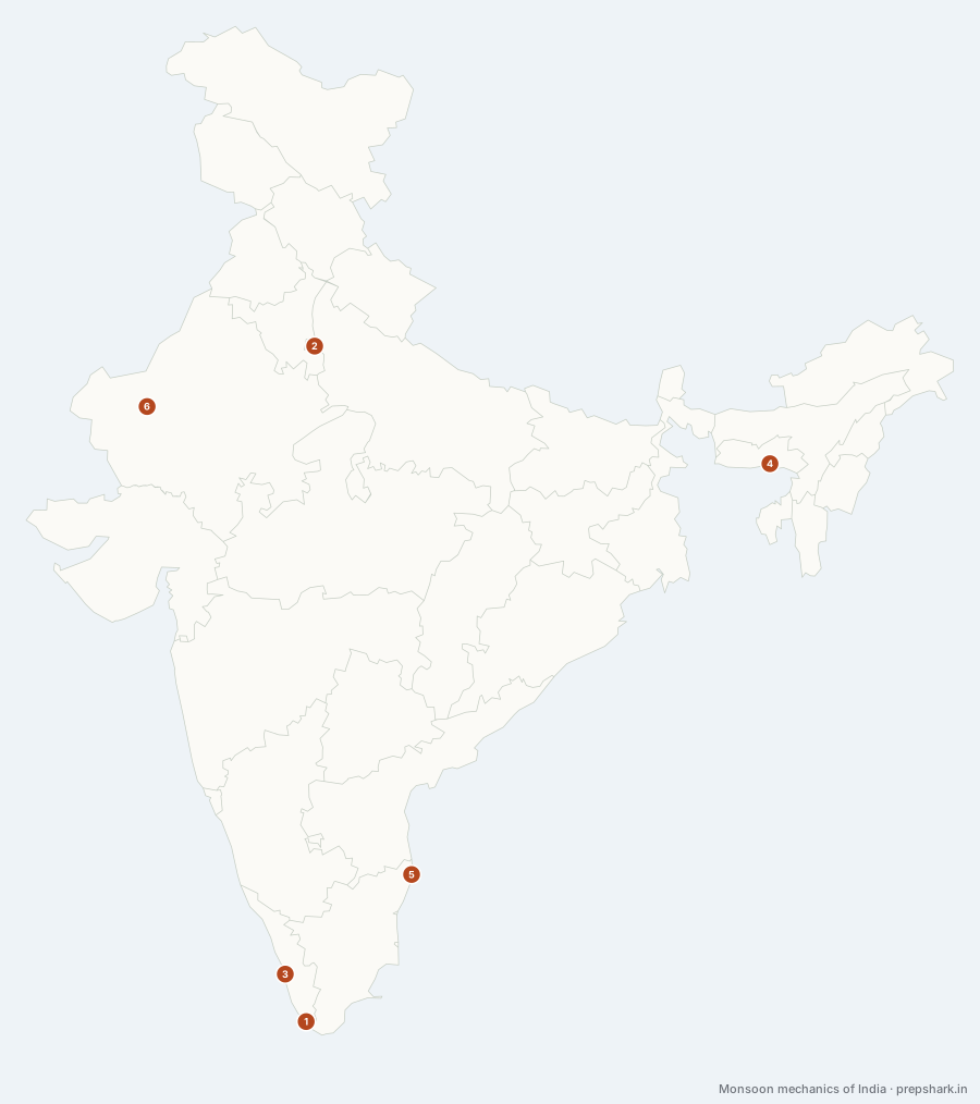
Numbered as on the map
The 6 on the map
1. Onset over Kerala
Kerala
Known forAbout 1 June, and the three conditions IMD needs before it says so
The monsoon reaches the Andaman Sea around 22 May and the Kerala coast around 1 June — the date the country’s farming calendar is built on. IMD declares it only when fourteen designated stations in Kerala and Lakshadweep report 2.5 mm of rain for two consecutive days, and the wind field and outgoing longwave radiation agree; rain alone is not enough, because pre-monsoon thunderstorms can imitate it for a week.
SettingSouth-west monsoon · onset · normal date 1 June · declared over Kerala and Lakshadweep
For the examThe onset is a WIND event as much as a rain event: rainfall over fourteen stations, westerly depth and wind speed, and outgoing longwave radiation, all together.
2. The advance
Delhi
Known forFive weeks from Kerala to the Thar, ending about 8 July
Five weeks to cross a subcontinent, and it does not cross it evenly. The two branches race up opposite coasts and meet over the northern plain: the peninsula is covered in a fortnight, the Gangetic plain by the third week of June, and the north-west last of all — the whole country by 8 July, a week earlier than the normal India used before 2020. The lines on the map are that progress, interpolated from IMD’s station normals.
SettingSouth-west monsoon · advance · Kerala 1 June to the whole country by 8 July · isochrones from 136 stations
For the examIMD reset these normals in 2020: the country is covered by 8 July, not the 15 July of the 1901–40 climatology.
3. The Arabian Sea branch
Kerala
Known forThe Somali jet, the Ghats, and the three arms it splits into
The larger of the two branches, and the one that arrives first. Air crossing the equator off Somalia is turned right by the earth’s rotation into a low-level jet, runs north-east across the Arabian Sea gathering moisture, and meets the Western Ghats broadside — a wall six hundred metres high and a thousand kilometres long standing square across the wind. It splits there into three: up the Konkan coast, through the Narmada–Tapi gap, and north-west along the Aravalli.
SettingSouth-west monsoon · Arabian Sea branch · onset over Kerala about 1 June · Somali jet and the Ghats
For the examIts third arm runs PARALLEL to the Aravalli rather than across it, which is why Rajasthan is dry and Meghalaya is not.
4. The Bay of Bengal branch
Meghalaya
Known forThe branch the Himalaya turns west up the Ganga plain
The branch that decides the north. It runs north up the Bay, strikes the Arakan hills of Myanmar, and is turned back on itself — one arm funnelled up the wedge-shaped valleys of the Khasi hills, where it produces the highest rainfall on earth, and the other deflected WEST by the Himalaya to travel up the Ganga plain. That deflection is why rainfall in the north falls off from Kolkata towards Delhi rather than inland from the coast.
SettingSouth-west monsoon · Bay of Bengal branch · onset over the north-east about 5 June · Arakan and Himalayan deflection
For the examKolkata, Patna, Allahabad, Delhi is the sequence to quote: rainfall falls off along the plain because the branch travels along it. Where this branch is forced up the Himalayan front it arrives as cloudbursts rather than as steady rain, which is the immediate cause of the landslides Uttarakhand and Himachal lose roads and villages to every season.
5. The north-east monsoon
Tamil Nadu
Known forTamil Nadu’s main rains, in October, November and December
The second monsoon, and the one the rest of India forgets. As the land cools in October the pressure gradient reverses and the winds blow out from the interior towards the sea — dry over most of the country, but over the Bay of Bengal they cross eight hundred kilometres of warm water and come ashore on the one coast that faces them. Tamil Nadu takes about half its annual rain in these three months, which is why its wet season is everyone else’s dry one.
SettingNorth-east monsoon · October–December · about half of Tamil Nadu’s annual rain · retreating winds over the Bay
For the examAlso called the retreating monsoon: the same air as the summer system, blowing the other way, and drawing its moisture from the Bay rather than the Arabian Sea. It is delivered in a handful of very heavy days rather than spread across the season, which is why Chennai floods on this monsoon and not on the other one.
6. The withdrawal
Rajasthan
Known forFrom about 17 September in the west Thar, and clear by 15 October
The retreat begins where the advance ended. From about 17 September the monsoon starts to withdraw from the western Thar — a fortnight later than the date India used before 2020 — and the retreat then runs faster than the advance ever did: most of the north-west is clear by 1 October and most of the country by 15 October. Withdrawal has no objective criterion the way onset does; IMD declares it from the drying of the wind field and the rainfall together.
SettingSouth-west monsoon · withdrawal · 17 September to 15 October · declared operationally, not by rainfall alone
For the examThe 2020 revision moved the start of withdrawal from 1 September to 17 September — a fortnight — while leaving the end of it in mid-October.
Keep going