Geography · Atlas of India
Peaks of India
Landforms, water, climate, and the hazards they carry.
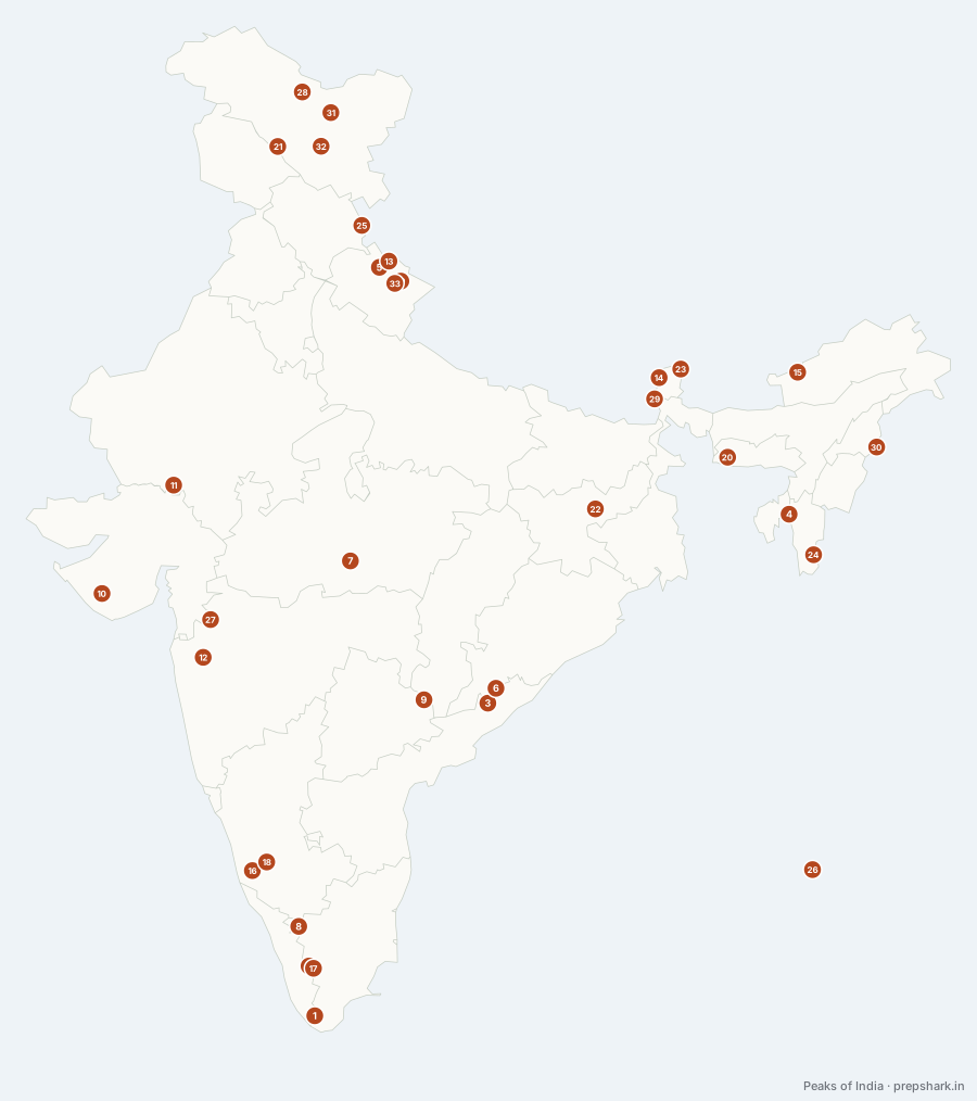
Numbered as on the map
The 33 on the map
1. Agastya Mala
Kerala
Known forThe highest point of the Agasthyamalai hills
The highest point of the Agasthyamalai hills at the southern end of the Western Ghats, and the core of a biosphere reserve that spans two states. The Kani people who live on it are the reason the arogyapacha plant became the first case in India of a community being paid a share of the royalties on their own traditional knowledge.
SettingSouthern Western Ghats · Agasthyamalai biosphere · shola
2. Anamudi
Kerala
Known forThe highest peak in peninsular India
The highest peak in the Western Ghats and in the whole of peninsular India, standing where the Anaimalai, Palani and Cardamom hills meet. Its name means elephant’s head, and the shola-grassland mosaic on its slopes is the habitat that holds the largest surviving Nilgiri tahr population.
SettingAnaimalai hills · shola and grassland · Nilgiri tahr
For the examHighest in peninsular India and in the Western Ghats. Doddabetta, in the Nilgiris, is the standing distractor.
3. Arma Konda
Andhra Pradesh
Known forThe highest point of the Eastern Ghats
The highest point of the Eastern Ghats, in the bauxite-bearing hills north of Paderu. The Survey of India sheets call it Sitamma Konda, which is why the same summit turns up under two names in two different sources and in two different questions.
SettingMadugula Konda · bauxite-bearing · Godavari basin
For the examHighest in the Eastern Ghats and in Andhra Pradesh. Also recorded as Sitamma Konda.
4. Betlingchhip
Tripura
Known forThe highest point in Tripura
The highest point in Tripura, on the Jampui hills along the Mizoram border. The state is a set of parallel north–south ridges separated by flat valleys, and this is the top of the easternmost of them — the same folding that raised the Purvanchal, at its gentlest.
SettingJampui hills · subtropical broadleaf · orange orchards
5. Chaukhamba
Uttarakhand
Known forThe highest peak of the Gangotri group
The highest peak of the Gangotri group, standing at the head of the Gangotri glacier itself — so the Bhagirathi, and therefore the Ganga, begins at its foot. Its four summits give it the name, and it is the eastern anchor of the group that also carries the Bhagirathi peaks and Shivling.
SettingGangotri glacier head · Garhwal Himalaya · Bhagirathi source
6. Deomali
Odisha
Known forThe highest point in Odisha
The highest point in Odisha, on the Chandragiri–Pottangi block of the Eastern Ghats above Koraput. These are the bauxite hills: the same flat-topped laterite caps that make the summits look shaved are the ore bodies, which is why this district is an industrial question as much as a physical one.
SettingEastern Ghats · bauxite-capped plateau · Koraput
For the examOdisha also has a Mahendragiri in the Eastern Ghats, and Tamil Nadu has a different Mahendragiri in the Western Ghats. Neither is the state high point; Deomali is.
7. Dhupgarh
Madhya Pradesh
Known forThe highest point of the Satpura and of Madhya Pradesh
The highest point of the Satpura and of Madhya Pradesh, on the Mahadeo hills above Pachmarhi. It sits in the middle of the Pachmarhi biosphere reserve, so the summit is one of the few places in central India where a reader can stand on the watershed between the Narmada and the Tapi.
SettingMahadeo hills · sandstone plateau · Pachmarhi biosphere
8. Doddabetta
Tamil Nadu
Known forThe highest point of the Nilgiris
The highest point of the Nilgiris, the block of hills where the Western and Eastern Ghats meet. Standing at the junction is what gives it its weather: it catches both the south-west and the retreating north-east monsoon, which almost nothing else in the peninsula does.
SettingNilgiri massif · shola and grassland · double monsoon
For the examHighest in the Nilgiris and in Tamil Nadu — not in peninsular India, which is Anamudi.
9. Doli Gutta
Telangana
Known forThe highest point in Telangana
The highest point in Telangana, on the northern edge of the Deccan plateau where the state meets Chhattisgarh. It is a reminder of what most of peninsular India actually is: not a range at all but a worn plateau, whose high points are residual hills rather than folded rock.
SettingDeccan plateau edge · dry deciduous · Godavari basin
10. Girnar
Gujarat
Known forThe highest point in Gujarat
The highest point in Gujarat, and an extinct volcanic complex rather than a fold or a plateau remnant — a plug of intrusive rock left standing after the softer Deccan lavas around it eroded away. It sits inside Gir, so the same hill carries the last wild Asiatic lions and an Ashokan rock edict at its foot.
SettingIgneous complex · Gir forest · dry deciduous
For the examAshoka’s Major Rock Edicts and later Rudradaman and Skandagupta inscriptions are on one boulder at its foot — a geography answer and a history answer on the same hill.
11. Guru Shikhar
Rajasthan
Known forThe highest point of the Aravalli
The highest point of the Aravalli and of the whole of western India — a granite dome at the southern end of a range that is otherwise worn almost flat. That contrast is the lesson: the Aravalli is one of the oldest fold ranges on earth, and Guru Shikhar is what is left standing after the rest of it eroded.
SettingAravalli granite · Mount Abu plateau · dry deciduous
For the examHighest in the Aravalli and in Rajasthan. Mount Abu is the hill station; Guru Shikhar is the peak above it.
12. Kalsubai
Maharashtra
Known forThe highest point in Maharashtra
The highest point in Maharashtra and in the northern Sahyadri, standing over the Bhandardara catchment on the Pravara. The Sahyadri here is a stack of basalt flows rather than folded rock — the flat-topped, stepped profile of every hill around it is the Deccan Traps in cross-section.
SettingNorthern Sahyadri · Deccan basalt · Pravara catchment
13. Kamet
Uttarakhand
Known forThe third highest mountain in India
The third highest mountain in India and the second in Garhwal, set back behind the main range close to the Tibet border — which is why it looks like a Tibetan plateau peak rather than a Himalayan one. It was the first summit above 7,600 m ever climbed, in 1931, more than twenty years before Everest.
SettingZaskar range · Chamoli · Tibetan-facing
For the examThird highest in India after Kangchenjunga and Nanda Devi, and second in Garhwal after Nanda Devi.
14. Kangchenjunga
Sikkim
Known forThe highest point in India; third highest on earth
The highest point in India and the third highest on earth, standing on the Sikkim–Nepal border at the eastern end of the Himalayan arc. It is not climbed to the true summit by convention — expeditions stop a few metres short out of respect for the Sikkimese belief that the top is the seat of a guardian deity, which is the only mountain in the world where that holds.
SettingEastern Himalaya · glaciated · Khangchendzonga biosphere
For the examHighest in India, but NOT entirely within it — the summit is on the border. Nanda Devi is the highest lying wholly inside the country. That pair is the question.
15. Kangto
Arunachal Pradesh
Known forThe highest point in Arunachal Pradesh
The highest point in Arunachal Pradesh, on the border with Tibet at the eastern end of the Himalayan arc. This is the stretch where the range is at its wettest: the Brahmaputra is about to turn the corner at Namcha Barwa, and the monsoon comes up these valleys with nothing in its way.
SettingEastern Himalaya · Tibet border · extreme rainfall gradient
16. Kudremukh
Karnataka
Known forThe third highest peak in Karnataka
The third highest peak in Karnataka, named for a horse-face profile, and the case study in what open-cast mining does to a catchment: iron ore was worked here until the Supreme Court stopped it in 2005, on the argument that the Bhadra downstream mattered more than the ore. The park now covers the mine.
SettingWestern Ghats · shola and grassland · Bhadra and Tunga catchment
17. Meesapulimala
Kerala
Known forThe second highest peak in the Western Ghats
The second summit of the Western Ghats after Anamudi, on the high range above Munnar where the tea estates stop and the shola-grassland takes over. The neelakurinji that flowers once in twelve years across these slopes is on this block, which is why one plant turns a hillside into a national event.
SettingMunnar high range · shola and grassland · neelakurinji
For the examSources differ on which summit is second in the Ghats — Meesapulimala is the usual answer, with Mannamalai on the same block disputing it. Anamudi is never in doubt.
18. Mullayanagiri
Karnataka
Known forThe highest point in Karnataka
The highest point in Karnataka, on the Chandra Drona ridge above Chikkamagaluru — the ridge that carries the state’s coffee belt. The Bhadra rises on these slopes, which is why the peak sits inside a catchment that feeds both a tiger reserve and a major irrigation project.
SettingBababudan range · shola and coffee slopes · Bhadra catchment
19. Nanda Devi
Uttarakhand
Known forThe highest peak wholly within India
The highest mountain lying entirely within India, ringed by a wall of peaks that made its inner basin one of the last unentered places in the Himalaya until 1934. That ring is now the core of a national park and a biosphere reserve, closed to entry — the protection is the reason the basin is still intact.
SettingGarhwal Himalaya · glacial sanctuary · closed core zone
For the examHighest ENTIRELY within India. Kangchenjunga is higher but straddles the Nepal border.
20. Nokrek
Meghalaya
Known forThe highest point of the Garo hills
The highest point of the Garo hills and the core of the Nokrek Biosphere Reserve, which exists for one plant: the slopes hold the largest surviving stand of wild citrus in the world, the ancestor of the cultivated orange. A biosphere reserve declared for a fruit rather than a mammal is unusual and is the whole point of the designation.
SettingGaro hills · wild citrus gene pool · Nokrek biosphere
21. Nun
Ladakh
Known forThe highest peak of the Nun Kun massif
The taller of the twin summits of the Nun Kun massif, and the highest point in the Indian Himalaya west of Nepal that is not in the Karakoram. The two peaks are separated by a four-kilometre snow plateau, which is why they are almost always named as a pair rather than singly.
SettingGreat Himalaya · Suru valley · heavily glaciated
22. Parasnath
Jharkhand
Known forThe highest point of the Chota Nagpur plateau; Sammet Shikhar
The highest point of the Chota Nagpur plateau and of Jharkhand, and the holiest hill in Jainism — twenty of the twenty-four Tirthankaras are held to have attained liberation on it. A residual hill standing well above a worn plateau is the classic monadnock, which is what makes it a physical-geography answer as well as a cultural one.
SettingChota Nagpur plateau · residual hill · dry deciduous
For the examAlso called Sammet Shikhar. Highest in Jharkhand and on the Chota Nagpur plateau.
23. Pauhunri
Sikkim
Known forThe highest peak of the Dongkya range; the source of the Teesta
The highest peak of the Dongkya range on the Sikkim–Tibet border, and the mountain the Teesta rises on. It has a second claim: when Alexander Kellas climbed it in 1911 he set a summit record that stood for years, and nobody noticed at the time because he published almost nothing.
SettingDongkya range · Tibet border · Teesta headwaters
24. Phawngpui
Mizoram
Known forThe highest point in Mizoram
The highest point in Mizoram, known as the Blue Mountain, on a ridge of the Lushai hills near the Myanmar border. The Mizo held it as the home of the spirits and left it uncleared, which is why a national park could be declared on ground that was never cut — the protection followed the belief rather than the other way round.
SettingLushai hills · montane forest and grassland · Blue Mountain park
25. Reo Purgyil
Himachal Pradesh
Known forThe highest point in Himachal Pradesh
The highest point in Himachal Pradesh, at the southern end of the Zanskar range on the Tibet border above the Sutlej. It stands over Kinnaur, which is the corridor the Sutlej uses to enter India at Shipki La — the pass and the peak are the same piece of geography seen twice.
SettingZanskar range · Kinnaur cold desert · Sutlej valley
26. Saddle Peak
Andaman and Nicobar Islands
Known forThe highest point of the Andaman and Nicobar Islands
The highest point of the Andaman and Nicobar Islands, on North Andaman inside its own national park. The islands are not a separate creation: they are the tops of the Arakan Yoma ridge continuing south under the Bay of Bengal and surfacing again as Sumatra, which is why the same subduction zone gives all three their earthquakes.
SettingNorth Andaman · evergreen island forest · Saddle Peak park
For the examThe islands continue the Arakan Yoma arc towards Sumatra. Saddle Peak is the archipelago high point; Mount Thullier is the Nicobar one.
27. Salher
Maharashtra
Known forThe second highest peak in Maharashtra
The second highest peak in Maharashtra and the highest fort in the Sahyadri, in the Baglan range north of Nashik. The 1672 battle fought below it was the first time a Maratha army beat a Mughal one in open field rather than from the hills, which is why a hill fort turns up in a question about pitched battles.
SettingBaglan range · Deccan basalt · Sahyadri fort country
28. Saltoro Kangri
Ladakh
Known forThe highest peak of the Saltoro range
The highest peak of the Saltoro range, the wall west of the Siachen glacier that Indian posts have held since 1984. The whole Siachen dispute is about this ridge rather than the glacier: whoever holds the Saltoro passes controls the approach, which is why the line on the ground is called the Actual Ground Position Line and not a border.
SettingKarakoram · Siachen approach · permanent snow
For the examThe Saltoro range, not the Siachen glacier, is what the AGPL runs along. Saltoro Kangri is its high point.
29. Sandakphu
West Bengal
Known forThe highest point in West Bengal; the Singalila ridge
The highest point in West Bengal, on the Singalila ridge that carries the Nepal border south from Kangchenjunga. It is the one place in India from which four of the world’s five highest mountains are visible at once, which is the whole reason the ridge has a walking route along it.
SettingSingalila ridge · temperate rhododendron · Nepal border
30. Saramati
Nagaland
Known forThe highest point of the Naga hills
The highest point of the Naga hills and of Nagaland, standing on the Myanmar border at the top of the Purvanchal arc. The Purvanchal is the Himalaya turning south — the same collision, bent through ninety degrees — which is why these hills run north to south while the main range runs east to west.
SettingPurvanchal · subtropical broadleaf · Indo-Myanmar hotspot
31. Saser Kangri
Ladakh
Known forThe highest peak of the Saser Muztagh
The highest peak of the Saser Muztagh, the easternmost block of the Karakoram, standing between the Nubra and the Shyok. The old Central Asian trade route from Leh to Yarkand crossed the Saser La beneath it — a caravan road over a glacier, and the reason this corner has a history at all.
SettingEastern Karakoram · Nubra and Shyok divide · heavily glaciated
32. Stok Kangri
Ladakh
Known forThe highest peak of the Stok range
The highest peak of the Stok range in the Zanskar mountains, rising straight off the Indus valley opposite Leh. It became the most-climbed six-thousander in India, and then the most cautionary: the trek was closed for rest in 2020 after the traffic outran what the mountain and its villages could carry.
SettingZanskar range · Hemis National Park · cold desert
33. Trisul
Uttarakhand
Known forThe highest of the Trisul group; the first 7,000 m peak climbed
Three peaks in a row named for the trident of Shiva, on the southern rim of the Nanda Devi sanctuary. Trisul I was the first mountain over 7,000 m anywhere to be climbed, in 1907 — the moment Himalayan mountaineering stopped being reconnaissance and became a sport.
SettingNanda Devi rim · Chamoli · Roopkund approach
Keep going