Geography · World Atlas
Deserts of the world
The earth's landforms and its ocean, and why each one sits where it does.
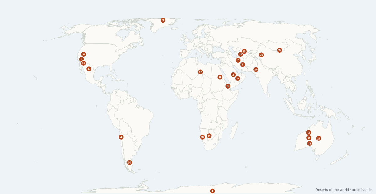
Numbered as on the map
The 26 on the map
1. Antarctic Polar Desert
Antarctica
Known forThe largest desert on earth, defined by precipitation rather than heat
The largest desert on earth — about 14 million km², larger than the Sahara — because a desert is defined by precipitation, not by temperature. The interior receives under 50 mm of water equivalent a year. The McMurdo Dry Valleys within it have been free of ice and rain for millions of years.
Settingpolar desert · ice sheet · hyper-arid
For the examThe trap question: the largest desert is Antarctic, not the Sahara. The Arctic polar desert is second. The Antarctic Treaty of 1959 governs it, and India runs Maitri and Bharati stations there.
2. Arabian Desert
Saudi Arabia
Known forThe peninsula-wide desert, and the world's largest sand sea within it
The continuation of the Saharan belt across the Red Sea, under the same subtropical high. It covers most of the Arabian peninsula and contains no permanent river at all — drainage is by wadi, and settlement by aquifer.
Settingsubtropical hot desert · sand sea · hyper-arid
For the examIt holds the Rub' al Khali. Saudi Arabia's fossil-aquifer wheat push and its later abandonment is the standard groundwater-depletion example.
3. Arctic Polar Desert
Greenland
Known forThe world's second largest desert
The northern polar desert — the Greenland ice sheet and the high Canadian and Russian Arctic islands, where the cold air holds too little moisture to precipitate. It is the second largest desert on earth.
Settingpolar desert · ice sheet · tundra margin
For the examGreenland's ice sheet is the second largest body of ice on earth; its melt is the largest single contributor to current sea-level rise from land ice.
4. Atacama
Chile
Known forRain some stations have never once recorded
The driest non-polar desert on earth, dried three ways at once: the subtropical high, the cold Humboldt Current offshore, and the Andes blocking Amazonian moisture from the east. Some weather stations have never recorded rain.
Settingcoastal hot desert · cold-current · hyper-arid
For the examThree causes together — subtropical high, cold current, rain shadow. It holds the Chilean end of the Lithium Triangle and the world's largest copper mines, Chuquicamata and Escondida.
5. Chihuahuan Desert
Mexico
Known forNorth America's largest desert, between the Sierra Madres
The largest desert in North America, a high desert mostly above 1,000 m on the Mexican Plateau between the two Sierra Madres. It is a rain-shadow desert, dried by both ranges at once.
Settinghigh desert · rain shadow · shrubland
For the examRain shadow from two directions. The Rio Grande crosses it, and the 1944 US–Mexico water treaty over that river is a live dispute in drought years.
6. Danakil Depression
Ethiopia
Known forThe hottest inhabited place, on a triple junction
A rift-floor desert more than 100 m below sea level, at the Afar triple junction where the Red Sea, Gulf of Aden and East African Rift meet. Annual mean temperatures above 34°C make it one of the hottest inhabited places measured, and its salt flats have been mined by camel caravan for centuries.
Settingrift depression · salt flat · hyper-arid
For the examA triple junction — three spreading boundaries meeting. It is the clearest place on land to see an ocean beginning to open.
7. Dasht-e Kavir
Iran
Known forIran's great salt desert
The Great Salt Desert of the northern Iranian Plateau — a closed basin whose drainage evaporates into salt crusts and treacherous marshes. Its salinity, not its heat, is what makes it near-impassable.
Settingsalt desert · playa · endorheic
For the examKavir means salt marsh; Dasht means plain. The pairing with the Lut — salt versus heat — is how the two are told apart.
8. Dasht-e Lut
Iran
Known forThe hottest land surface temperature ever recorded
A closed basin on the Iranian Plateau where satellites have recorded the highest land surface temperatures ever measured, above 70°C. Its yardangs — wind-cut ridges called kaluts — run for tens of kilometres in parallel.
Settinghot desert · yardang field · endorheic
For the examSurface temperature, not air temperature — the record for air temperature is Death Valley. It is a UNESCO World Heritage site for its yardangs.
9. Gibson Desert
Australia
Known forThe gravel desert between Australia's two great sand deserts
The middle band of Western Australia's deserts, between the Great Sandy to the north and the Great Victoria to the south — gravel plain and laterite rather than dune sea.
Settinghot desert · gravel plain · spinifex
10. Gobi
Mongolia
Known forAsia's great cold desert, in the Himalayan rain shadow
A cold desert made by distance and by barriers: it is thousands of kilometres from any ocean, and the Himalaya and Tibetan Plateau block the monsoon from the south. Winter temperatures fall below −40°C, so it is a rain-shadow and continental desert rather than a subtropical one.
Settingcold desert · gravel and steppe · continental
For the examCold desert, and the cause is rain shadow plus continentality — not subtropical high. It is the source of the spring dust storms that reach Beijing, Korea and Japan.
11. Great Basin
United States of America
Known forThe endorheic cold desert of the American West
A cold desert of parallel ranges and closed valleys — the Basin and Range province — with no drainage to any ocean. Its water ends in salt lakes and playas, of which the Great Salt Lake is the largest.
Settingcold desert · basin and range · endorheic
For the examEndorheic — no outlet. The Great Salt Lake hit a record low in 2022 and its exposed arsenic-bearing lakebed is now a public-health issue, which is the version of this that reaches current affairs.
12. Great Sandy Desert
Australia
Known forAustralia's northern sand-ridge desert
The northern of Australia's great deserts, a belt of parallel red sand ridges reaching almost to the Indian Ocean. It gets erratic summer rain from the tail of the Australian monsoon and from decaying tropical cyclones.
Settinghot desert · longitudinal dunes · spinifex
For the examAustralia's longitudinal (seif) dunes run parallel to the prevailing wind and are the continent's signature desert landform.
13. Great Victoria Desert
Australia
Known forAustralia under the subtropical high
Australia's largest desert, straddling the Western Australia–South Australia border under the subtropical high. Australia is the driest inhabited continent because it sits almost entirely in that high-pressure belt and has no mountains high enough to wring out moisture.
Settingsubtropical hot desert · sand ridge · spinifex
For the examAustralia's aridity is a subtropical-high story plus a flat, low continent. Maralinga, the British nuclear test site, is on its southern edge.
14. Kalahari
Botswana
Known forA sand basin with no drainage to the sea
A vast sand basin rather than a true desert — much of it gets enough rain for grass and thorn scrub, so it is better called a semi-desert. It has no surface drainage to the sea, and the Okavango dies in its northern edge as an inland delta.
Settingsand basin · semi-desert · savanna scrub
For the examIt is a semi-desert, not hyper-arid — the distinction the stem tests against the Namib beside it. The Okavango inland delta is a Ramsar site and a World Heritage site.
15. Karakum
Turkmenistan
Known forThe Black Sands, and the canal that drained the Amu Darya
The Black Sands, covering most of Turkmenistan. The Karakum Canal takes water from the Amu Darya right across it — one of the largest irrigation canals in the world, and the other half of the reason the Aral Sea died.
Settingcold desert · sandy · continental
For the examThe Karakum Canal is the named diversion. The Darvaza gas crater, burning since 1971, sits in it and Turkmenistan has repeatedly announced plans to extinguish it.
16. Kyzylkum
Uzbekistan
Known forThe Red Sands between the Amu Darya and Syr Darya
The Red Sands, between the Amu Darya and the Syr Darya. Diverting both rivers to irrigate cotton across this desert is what emptied the Aral Sea — the largest deliberate destruction of a lake in history.
Settingcold desert · sandy · continental
For the examThe Aral Sea shrank because the Amu Darya and Syr Darya were taken for cotton here and in the Karakum. Name both rivers — the stem usually asks for them.
17. Mojave Desert
United States of America
Known forDeath Valley, and the highest recorded air temperature
The smallest and driest North American desert, in the rain shadow of the Sierra Nevada. It contains Death Valley, where the highest reliably recorded air temperature on earth — 56.7°C — was measured in 1913, and Badwater Basin at 86 m below sea level.
Settinghot desert · rain shadow · basin and range
For the examAir-temperature record here; land-surface record in the Lut. Badwater is the lowest point in North America.
18. Namib
Namibia
Known forThe fog desert made by the Benguela Current
A coastal desert made by a cold current: the Benguela chills the air above it, so moisture condenses as fog offshore instead of rain onshore. The result is one of the driest places on earth sitting directly on an ocean, with life on the dunes living off that fog.
Settingcoastal fog desert · cold-current · hyper-arid
For the examCold-current desert — the same mechanism as the Atacama under the Humboldt. The Skeleton Coast is the fog-wrecked shore, and Sossusvlei the classic dune field.
19. Nubian Desert
Sudan
Known forThe Sahara's rocky eastern arm, cut by the Nile
The rocky eastern arm of the Sahara between the Nile and the Red Sea, almost rainless and largely without dunes — bare rock and gravel rather than sand. The Nile's great S-bend swings through it, and the Aswan reservoir drowned Nubian settlements along it.
Settinghamada · hyper-arid · rock and gravel
For the examHamada — rock desert, the contrast with the erg sand seas. Lake Nasser and the resited Abu Simbel temples are on its Nile edge.
20. Patagonian Desert
Argentina
Known forThe Americas' largest desert, in the Andean rain shadow
The largest desert in the Americas and the only large mid-latitude desert in the southern hemisphere, lying in the Andean rain shadow of the westerlies. It is cold and ferociously windy rather than hot.
Settingcold desert · rain shadow · steppe
For the examRain shadow of the WESTERLIES, so the mountains lie to the west — the opposite geometry to a monsoon rain shadow. Vaca Muerta, Argentina's shale play, is in its northern part.
21. Rub' al Khali (Empty Quarter)
Saudi Arabia
Known forThe Empty Quarter, and four countries' back door
The largest continuous sand sea on earth, about 650,000 km² of dunes reaching 250 m. It is shared by Saudi Arabia, Oman, the UAE and Yemen, and much of the Saudi–UAE and Saudi–Oman boundary through it was left undefined for decades because nobody lived there.
Settingerg · hyper-arid · dune field
For the examFour countries: Saudi Arabia, Oman, UAE, Yemen. Shaybah, one of Saudi Arabia's major oil fields, is under its eastern edge.
22. Sahara
Algeria
Known forThe largest hot desert, made by the descending Hadley limb
The largest hot desert on earth, about 9 million km² across eleven countries, and a textbook subtropical desert: it sits under the descending limb of the Hadley cell at roughly 20–30°N, where air that rose at the equator returns warm and dry. Its dust crosses the Atlantic and fertilises the Amazon.
Settingsubtropical hot desert · erg and hamada · trade-wind belt
For the examSubtropical high pressure is the cause, not distance from the sea. The Sahel on its southern edge is the desertification case study, and the Great Green Wall the response.
23. Simpson Desert
Australia
Known forA thousand red dunes, all running one way
The centre of Australia, and the world's largest parallel-dune desert — over a thousand ridges running north-north-west for up to 200 km each. It drains inward to Lake Eyre, which fills only in exceptional years.
Settinghot desert · longitudinal dunes · endorheic
For the examIt drains into the Lake Eyre basin, Australia's great endorheic system. Big fill years are driven by monsoon rain a thousand kilometres to the north.
24. Sonoran Desert
United States of America
Known forThe saguaro desert, with two rainy seasons
The wettest of the North American deserts, with two rainy seasons — winter Pacific fronts and a summer monsoon off the Gulf of California. That double rainfall is why it grows the saguaro cactus and supports the richest desert flora on the continent.
Settinghot desert · bi-seasonal rain · cactus scrub
For the examThe North American Monsoon is real and this is where it lands — the exception to the assumption that monsoons are an Asian phenomenon. The Colorado River, which crosses it, no longer reaches the sea in most years.
25. Taklamakan
China
Known forThe sand sea inside the Tarim Basin
A sand sea filling the Tarim Basin, ringed by the Tian Shan, Kunlun and Pamir so completely that almost no moisture reaches it. Its rivers run off the mountains and vanish into the sand; the Silk Road split to skirt it on either side rather than cross it.
Settingcold desert · erg · intermontane basin
For the examRinged by three ranges — the reason it is one of the driest places in Asia. The Tarim River runs along its northern edge and ends in the shifting Lop Nur, China's former nuclear test site.
26. Thar Desert
India
Known forThe most densely populated desert on earth
The eastern end of the Saharan–Arabian belt, and the most densely populated desert in the world. It is dry for two reasons at once: it is on the subtropical high, and the Aravallis run parallel to the monsoon flow rather than across it, so the south-west monsoon slides past without being forced to rise.
Settingsubtropical hot desert · sandy · monsoon-marginal
For the examThe Aravalli's orientation — parallel to the monsoon current — is the standard explanation asked for. The Indira Gandhi Canal from the Sutlej is the irrigation answer, and waterlogging its side effect.
Keep going