Geography · World Atlas
Islands & archipelagos of the world
The earth's landforms and its ocean, and why each one sits where it does.
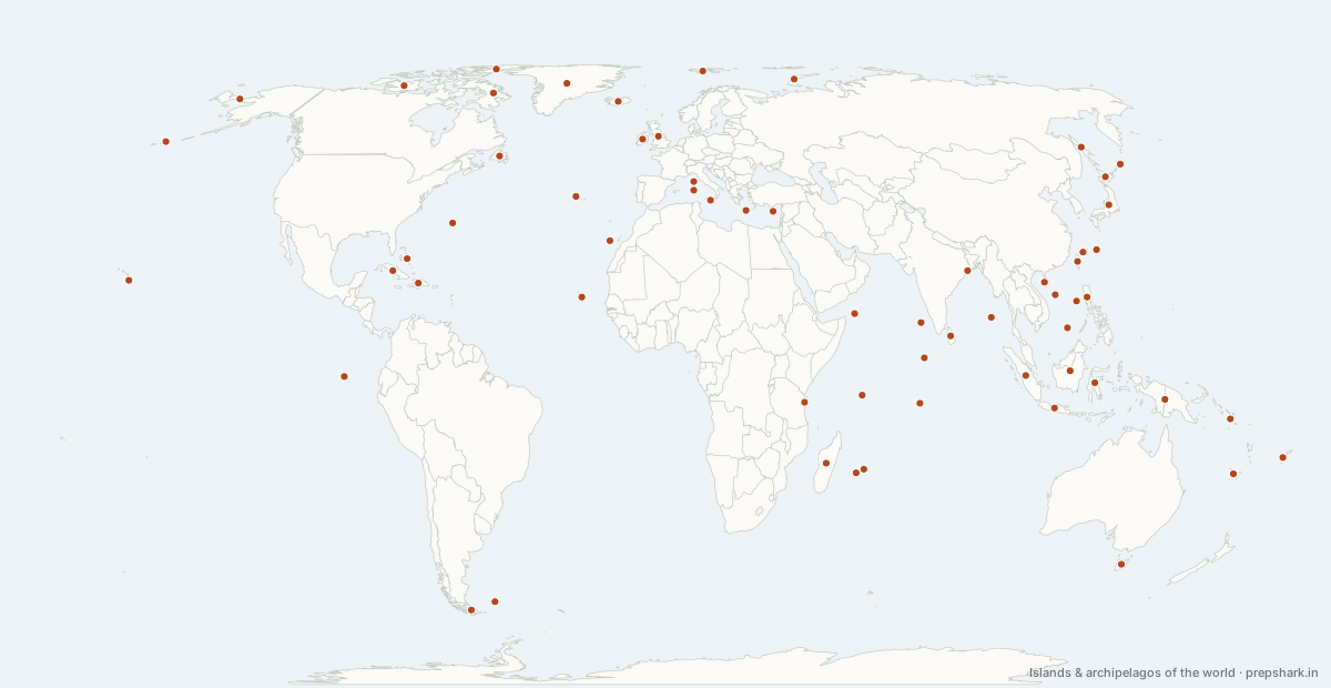
Numbered as on the map
The 61 on the map
1. Aleutian Islands
United States of America
Known forThe arc that closes the Bering Sea
A 1,900 km volcanic arc curving from Alaska toward Kamchatka, where the Pacific Plate subducts beneath North America. The arc separates the Bering Sea from the Pacific and crosses the 180th meridian, so the islands lie in both eastern and western hemispheres.
Settingvolcanic island arc · subduction · sub-Arctic
For the examAn island arc, the classic ocean–ocean-margin form. The chain crosses the International Date Line, which jogs around it.
2. Andaman and Nicobar Islands
India
Known forIndia's forward islands, guarding the approach to Malacca
India's Bay of Bengal archipelago, 572 islands running north–south along the emergent crest of the Arakan–Sunda arc. They give India an exclusive economic zone reaching toward the Strait of Malacca, and host the country's only tri-service command. The Sentinelese on North Sentinel Island remain uncontacted by choice.
Settingarc archipelago · tropical rainforest · coral fringed
For the examIndira Point on Great Nicobar is India's southernmost point. Barren Island nearby is India's only active volcano. The Great Nicobar development project and its ecological objections are the live policy argument.
3. Azores
Portugal
Known forA triple junction, and the high that steers Europe's weather
A volcanic archipelago at the Azores triple junction, where the North American, Eurasian and African plates meet on the Mid-Atlantic Ridge. The Azores High — the semi-permanent subtropical anticyclone centred near it — is one of the two poles of the North Atlantic Oscillation that sets European winter weather.
Settingridge archipelago · triple junction · oceanic temperate
For the examThe North Atlantic Oscillation is the pressure difference between the Azores High and the Icelandic Low — the standard teleconnection index for European winters.
4. Baffin Island
Canada
Known forCanada's largest island
The fifth largest island and the largest in Canada, in the Canadian Arctic Archipelago. The Northwest Passage threads between it and the islands to its north and west.
SettingArctic island · fjords · tundra
5. Bahamas
Bahamas
Known forThe Atlantic's great carbonate platform
A chain of low carbonate banks north of Cuba, built by coral and ooid sand on a subsiding platform over 100 million years. Almost nothing rises above 60 m, which is why Hurricane Dorian in 2019 was so destructive.
Settingcarbonate platform · very low-lying · hurricane belt
6. Bermuda
United Kingdom
Known forThe Atlantic's isolated coral cap
An isolated volcanic seamount capped with coral in the western North Atlantic, at the north-west corner of the Sargasso Sea. The Gulf Stream passing to its west keeps it subtropical at the latitude of North Carolina.
Settingseamount island · coral cap · subtropical
7. Borneo
Indonesia
Known forThe island shared by three countries, and Indonesia's new capital
The third largest island and the only one divided between three countries — Indonesia, Malaysia and Brunei. Its peat swamp forests hold enormous carbon, and their drainage and burning for oil palm is a major emissions source. Indonesia's new capital Nusantara is being built on its eastern coast.
Settingequatorial island · peat swamp · rainforest
For the examThree countries — the fact the stem turns on. Nusantara is being built in East Kalimantan because Jakarta on Java is sinking and overcrowded.
8. Canary Islands
Spain
Known forSpain's Atlantic volcanoes
A volcanic hotspot chain off north-west Africa, carrying Teide — Spain's highest peak at 3,715 m. The Cumbre Vieja eruption on La Palma in 2021 destroyed some 3,000 buildings over 85 days.
Settinghotspot archipelago · volcanic · trade-wind
For the examThe trade winds give the northern slopes a cloud forest while the south is desert — a compact demonstration of orographic asymmetry.
9. Cape Verde
Cabo Verde
Known forWhere Atlantic hurricanes are born
A volcanic archipelago off West Africa in the path of Saharan dust and of the easterly waves that become Atlantic hurricanes — the strongest hurricanes usually begin here, and are called Cape Verde-type storms.
Settinghotspot archipelago · Sahel-arid · hurricane seedbed
For the examCape Verde-type hurricanes form from African easterly waves and have the longest track and the most time to intensify.
10. Chagos Archipelago
Mauritius
Known forDiego Garcia, and a sovereignty question settled in 2024
A group of atolls in the central Indian Ocean whose largest, Diego Garcia, is a major United States military base. The International Court of Justice advised in 2019 that the United Kingdom's separation of the archipelago from Mauritius was unlawful; in 2024 the United Kingdom agreed to transfer sovereignty to Mauritius while retaining the base under a long lease.
Settingatoll archipelago · coral · Chagos-Laccadive Ridge
For the examThe 2019 ICJ advisory opinion and the 2024 UK–Mauritius agreement are the two steps to name. The Chagossians expelled in the 1960s and 70s have still not been returned to Diego Garcia.
11. Corsica
France
Known forFrance's mountainous Mediterranean island
A mountainous French Mediterranean island, geologically a fragment of the same block as Sardinia, from which it is separated by the narrow Strait of Bonifacio.
Settingcontinental fragment · maquis · mountainous
12. Crete
Greece
Known forThe Aegean's southern wall, and Minoan Crete
The largest Greek island and the southern wall of the Aegean, sitting directly above the Hellenic subduction zone where Africa dives under Europe. The Minoan civilisation on it was disrupted by the Thera eruption around 1600 BCE.
Settingcontinental island · subduction margin · Mediterranean
13. Cuba
Cuba
Known forThe largest Caribbean island
The largest island in the Caribbean, lying across the approaches to the Gulf of Mexico and the Florida Strait — the geography behind both the 1962 missile crisis and the long United States embargo.
Settingcontinental island · karst · hurricane belt
14. Cyprus
Cyprus
Known forA divided island, and the world's clearest ophiolite
The third largest Mediterranean island, divided since 1974 by a United Nations buffer zone between the Republic of Cyprus and the self-declared Turkish Republic of Northern Cyprus, recognised only by Türkiye. Its Troodos massif is the best-exposed ophiolite in the world — a complete slice of ocean crust lifted onto land.
Settingophiolite island · Mediterranean · divided
For the examTroodos is the type example of an ophiolite and how ocean crust was first understood. Offshore gas around it is contested between Cyprus, Türkiye and Greece.
15. Diomede Islands
United States of America
Known forTwo islands, two countries, and almost a day apart
Two small islands 3.8 km apart in the middle of the Bering Strait, with the International Date Line and the Russia–United States border between them — so Big Diomede is almost a full day ahead of Little Diomede. They are the closest point between the two countries.
Settingstrait islands · Arctic · rocky
For the examCalled Tomorrow Island and Yesterday Isle. The 1867 Alaska Purchase boundary runs between them.
16. Ellesmere Island
Canada
Known forThe northernmost large island, losing the last Arctic ice shelves
The northernmost large island on earth, reaching within 800 km of the North Pole. Its ice shelves — the last in the northern hemisphere — have broken up almost entirely since 2000, the Milne shelf collapsing in 2020.
Settinghigh Arctic island · ice caps · polar desert
For the examHans Island between it and Greenland was disputed for fifty years and split between Canada and Denmark in 2022, creating Canada's first land border with a European state.
17. Falkland Islands (Islas Malvinas)
United Kingdom
Known forThe disputed South Atlantic islands
A South Atlantic archipelago on the Patagonian shelf, administered by the United Kingdom and claimed by Argentina as the Islas Malvinas — the subject of the 1982 war and of a continuing claim before the United Nations Special Committee on Decolonization.
Settingshelf archipelago · sub-Antarctic · tussock grassland
18. Fiji
Fiji
Known forThe Pacific archipelago the Date Line bends around
A volcanic archipelago in the south-west Pacific, sitting almost exactly on the 180th meridian so the International Date Line jogs east around it to keep the country on one date. It is the diplomatic hub of the Pacific Islands Forum.
Settingvolcanic archipelago · tropical · cyclone belt
For the examThe Date Line is not the 180th meridian — it bends around Fiji, Kiribati and the Aleutians so countries are not split across two dates.
19. Galápagos Islands
Ecuador
Known forWhere natural selection was worked out
A hotspot archipelago on the Equator, cooled by the Humboldt Current so that penguins live at the equator. Darwin's finches here supplied the observations behind natural selection, and the surrounding marine reserve was enlarged in 2022 to protect a migration corridor to Cocos Island.
Settinghotspot archipelago · cold-current tropical · endemic
For the examThe Humboldt Current is why an equatorial archipelago has penguins and cool water — the counter-intuitive fact the stem uses.
20. Great Britain
United Kingdom
Known forEurope's largest island
The largest island in Europe, separated from the continent only about 8,000 years ago when rising seas drowned Doggerland. The Gulf Stream's extension keeps it far milder than its latitude — it lies as far north as Labrador.
Settingshelf island · temperate maritime · recently separated
21. Greenland
Denmark
Known forThe largest island, and the fastest-melting large ice sheet
The largest island on earth at 2.17 million km², and 80% covered by an ice sheet up to 3 km thick — enough water to raise global sea level by about 7 m. An autonomous territory of Denmark, it left the European Communities in 1985 while Denmark stayed, and it holds very large rare-earth deposits at Kvanefjeld.
SettingArctic island · ice sheet · tundra margin
For the examAustralia is a continent, not an island, which is why Greenland is the largest. Its ice sheet is the single largest land contributor to current sea-level rise.
22. Hainan
China
Known forChina's tropical island and submarine base
China's southernmost province and its tropical island, separated from the mainland by the Qiongzhou Strait. Yulin on its southern coast is a major submarine base with direct deep-water access to the South China Sea, which is a large part of why that sea matters to Beijing.
Settingcontinental island · tropical monsoon · typhoon belt
For the examSanya's deep-water access lets ballistic-missile submarines reach the open Pacific without surfacing — the strategic logic behind China's South China Sea posture.
23. Hawaiian Islands
United States of America
Known forThe textbook hotspot chain
The type example of a hotspot chain: the Pacific Plate moves north-west over a fixed plume, so the islands get older the further north-west you go and the bend in the Hawaiian–Emperor chain records a change in plate motion. Mauna Kea measured from its base on the sea floor is the tallest mountain on earth at over 10,000 m.
Settinghotspot archipelago · shield volcanoes · endemic
For the examAge progression along the chain proves the plate moves and the plume does not. Mauna Kea is tallest from base; Everest is highest above sea level; Chimborazo is furthest from earth's centre.
24. Hispaniola
Haiti
Known forThe island shared by two countries
The only Caribbean island divided between two sovereign states, Haiti and the Dominican Republic. It sits on a strike-slip fault system that produced the 2010 Haiti earthquake, and the deforestation contrast across the border is visible from orbit.
Settingcontinental island · strike-slip fault · hurricane belt
25. Hokkaido
Japan
Known forJapan's northern island, and its extraordinary snow
Japan's northern island, cold enough for a genuinely continental winter because the Siberian high sends dry air across the Sea of Japan, which picks up moisture and dumps it as some of the heaviest snowfall on earth.
Settingarc island · sea-effect snow · subarctic
For the examSea-effect snow: cold continental air crossing warm water. The same mechanism gives the American Great Lakes their lake-effect snow.
26. Honshu
Japan
Known forJapan's main island, on a four-plate junction
Japan's main island and the seventh largest in the world, sitting where four plates meet. Mount Fuji stands on the triple junction; the 2011 Tōhoku earthquake off its north-east coast produced a tsunami that caused the Fukushima Daiichi accident.
Settingarc island · volcanic · seismic
For the examThe Fossa Magna rift crosses it, dividing north-east from south-west Japan. The 2011 tsunami and Fukushima are the standard compound-disaster case.
27. Iceland
Iceland
Known forWhere the Mid-Atlantic Ridge comes ashore
The only place where a mid-ocean ridge rises above sea level, because a mantle plume sits under the Mid-Atlantic Ridge here. The island is splitting: North America and Eurasia pull apart across it at about 2 cm a year, and the Reykjanes peninsula entered a new eruptive phase in 2021 that has repeatedly threatened Grindavík since late 2023.
Settinghotspot island · spreading ridge · glaciers and volcanoes
For the examA ridge and a hotspot together. Eyjafjallajökull's 2010 ash cloud closed European airspace — the standard example of a small eruption with global economic effect.
28. Ireland
Ireland
Known forEurope's western island, and a border that shaped Brexit
A saucer-shaped island — mountains around a low, boggy centre — divided between the Republic and Northern Ireland. Its blanket bogs are among the largest in Europe, and the border across it became a defining problem of the United Kingdom's exit from the European Union.
Settingshelf island · blanket bog · temperate maritime
29. Java
Indonesia
Known forThe world's most populous island
The most populous island on earth — over 150 million people on an area smaller than Nepal — because its volcanic ash soils are exceptionally fertile. It carries Merapi and Krakatoa, and Jakarta on its north coast is sinking up to 25 cm a year from groundwater extraction.
Settingvolcanic arc island · fertile ash soils · dense
For the examVolcanic soil fertility is the causal link asked for. Jakarta's subsidence is why the capital is moving to Nusantara on Borneo.
30. Kuril Islands
Russia
Known forThe arc Japan calls the Northern Territories
A volcanic arc from Kamchatka to Hokkaido, enclosing the Sea of Okhotsk. Russia holds them; Japan claims the four southernmost as the Northern Territories, which is why the two countries have never signed a peace treaty ending the Second World War.
Settingvolcanic island arc · subduction · sub-Arctic
For the examFour islands: Iturup, Kunashir, Shikotan and the Habomai group. The Kuril–Kamchatka Trench runs along their Pacific side.
31. Lakshadweep
India
Known forIndia's coral atolls, and the sea they generate
India's Arabian Sea archipelago — 36 coral atolls and reefs, the northern extension of the same submarine ridge as the Maldives and Chagos. Total land area is only about 32 km², but the exclusive economic zone it generates is over 400,000 km².
Settingatoll archipelago · coral · very low-lying
For the examAtolls: a coral ring on a subsiding volcanic base — Darwin's subsidence theory. They are among the most exposed places in India to sea-level rise.
32. Luzon
Philippines
Known forThe main Philippine island, and Pinatubo
The largest and most populous Philippine island, carrying Manila. Mount Pinatubo on it erupted in 1991 — the second largest eruption of the 20th century — and cooled global average temperature by about 0.5°C for two years.
Settingarc island · volcanic · typhoon belt
For the examPinatubo 1991 is the standard example of volcanic aerosols forcing global climate. Scarborough Shoal, seized by China in 2012, lies off its west coast.
33. Madagascar
Madagascar
Known forThe island where nine species in ten are found nowhere else
The fourth largest island, separated from Africa for about 88 million years, which is why roughly 90% of its wildlife exists nowhere else — every lemur, most of its chameleons. Its eastern slope catches the trade winds and is rainforest; its west is dry.
Settingcontinental island · endemic · trade-wind asymmetry
For the examA continental fragment, not a volcanic island — which is why it has old lineages rather than recent colonists. It is one of the world's biodiversity hotspots.
34. Maldives
Maldives
Known forThe world's lowest-lying country
The lowest country on earth: about 80% of its land is under one metre above sea level and its highest natural point is roughly 2.4 m. It is the standard case for existential sea-level risk, and it sits astride the east–west shipping lanes of the northern Indian Ocean.
Settingatoll nation · coral · under 2.4 m
For the examTwenty-six natural atolls. India's 2024 troop withdrawal and the shift toward China under the Muizzu government is the current strategic story; the Maldives sits on the eight-degree and one-and-a-half-degree channels.
35. Mauritius
Mauritius
Known forA hotspot island, the dodo, and the Chagos settlement
A volcanic island on the Réunion hotspot track — the same plume that erupted the Deccan Traps as India passed over it. It was the only home of the dodo, extinct within a century of European arrival. It is also the state to which the Chagos Archipelago was returned by agreement with the United Kingdom in 2024.
Settinghotspot island · volcanic · coral fringed
For the examThe Réunion hotspot track runs Deccan Traps → Laccadive-Chagos Ridge → Mauritius → Réunion, and dates the Deccan eruption to India's passage over it.
36. New Caledonia
France
Known forZealandia's nickel island
A continental fragment of Zealandia in the south-west Pacific, holding roughly a tenth of world nickel reserves in its ultramafic soils. Its lagoon is a World Heritage site, and unrest over voting rights in 2024 revived the independence question.
Settingcontinental fragment · ultramafic soils · barrier reef
37. New Guinea
Papua New Guinea
Known forThe second largest island, and 800 languages
The second largest island, and the most linguistically diverse place on earth with over 800 languages. It is split down the 141°E meridian between Papua New Guinea and Indonesia, and its central cordillera reaches 4,884 m at Puncak Jaya — glaciated, at four degrees from the equator, though the glaciers are nearly gone.
Settingtropical island · high cordillera · rainforest
For the examPuncak Jaya is the highest island peak in the world and one of the Seven Summits. The Grasberg mine on it is the world's largest gold mine.
38. Newfoundland
Canada
Known forThe Grand Banks, and a fishery that collapsed
The island off Canada's east coast beside the Grand Banks, where the cold Labrador Current meets the warm Gulf Stream. That meeting made one of the greatest fisheries in history and also produces the region's fog; the cod fishery collapsed in 1992 and has never recovered.
Settingshelf island · current convergence · boreal
For the examThe 1992 northern cod moratorium is the reference case for fishery collapse and the tragedy of the commons.
39. Novaya Zemlya
Russia
Known forThe Urals' Arctic continuation, and a nuclear test site
A long double island continuing the Ural range into the Arctic, separating the Barents Sea from the Kara Sea. It was the Soviet Union's northern nuclear test site, where the Tsar Bomba — the largest nuclear device ever detonated — was tested in 1961.
SettingArctic island · glaciated · tundra
40. Paracel Islands
disputed
Known forThe group China took by force in 1974
A group in the northern South China Sea taken by China from South Vietnam by force in 1974 and administered since; Vietnam and Taiwan both claim them. Woody Island carries an airfield, a garrison and the seat of China's Sansha City.
Settingreef archipelago · garrisoned · disputed
For the examChina drew straight baselines around the whole group in 1996 — a claim that treats them as an archipelago, which UNCLOS allows only for archipelagic STATES.
41. Réunion
France
Known forThe hotspot's present position, and the world's rainfall records
The current position of the Réunion hotspot, carrying Piton de la Fournaise — one of the most frequently erupting volcanoes on earth. It holds most world rainfall records for durations from 12 hours to 15 days, set by tropical cyclones forced up its slopes.
Settinghotspot island · shield volcano · orographic extremes
For the examCyclone Denise in 1966 delivered 1,825 mm in 24 hours here — the world record. As a French overseas department it makes France an Indian Ocean state and an EU outermost region.
42. Ryukyu Islands
Japan
Known forThe first island chain's middle, and the Miyako Strait
The arc running from Kyushu toward Taiwan, forming the middle of the first island chain and separating the East China Sea from the Pacific. Okinawa carries the largest concentration of United States forces in Japan, and the Miyako Strait through the chain is the main route for Chinese naval transit into the Pacific.
Settingisland arc · subtropical · coral fringed
For the examThe Miyako Strait between Okinawa and Miyako is wide enough to be international water and is the standard transit route watched in East Asian naval reporting.
43. Sagar and the Sundarbans islands
India
Known forThe world's largest mangrove, and islands already lost
The delta islands at the mouth of the Ganga–Brahmaputra system, shared by India and Bangladesh. They are the largest mangrove forest in the world and the only mangrove with a resident tiger population, and several islands — Lohachara, New Moore — have already disappeared under rising water and erosion.
Settingdelta islands · mangrove · subsiding and eroding
For the examNew Moore (South Talpatti) was disputed between India and Bangladesh until it vanished around 2010 — the dispute ended because the island did. The 2014 UNCLOS award settled the maritime boundary between the two.
44. Sakhalin
Russia
Known forRussia's Pacific oil and gas island
A long island off the Russian Far East, separated from the mainland by the shallow Tatar Strait and from Hokkaido by the La Pérouse Strait. Sakhalin-1 and Sakhalin-2 are major oil and gas projects, and Japanese and Indian firms have both held stakes.
Settingcontinental island · subarctic · hydrocarbon province
For the examJapan held the southern half from 1905 to 1945; the residual dispute is over the Kurils, not Sakhalin. ONGC Videsh holds a stake in Sakhalin-1.
45. Sardinia
Italy
Known forThe Mediterranean's second island
The second largest Mediterranean island, a continental fragment rifted away from Europe. Its interior is old, hard rock and thinly populated, and it is one of the world's Blue Zones for longevity.
Settingcontinental fragment · maquis · Mediterranean
46. Scarborough Shoal
disputed
Known forThe shoal China took in 2012
A large triangular reef about 220 km from Luzon and well inside the Philippine exclusive economic zone. China took effective control after a standoff in 2012 and has controlled access to it since, which was among the issues in the case the Philippines brought under UNCLOS.
Settingatoll reef · rich fishery · disputed
For the examThe 2016 tribunal found China had unlawfully interfered with Philippine fishing rights here and that the shoal is a traditional fishing ground for several nationalities.
47. Senkaku Islands (Diaoyu)
Japan
Known forThe uninhabited islets China and Japan both claim
Five uninhabited islets in the East China Sea administered by Japan and claimed by both China and Taiwan. Interest in them rose sharply after a 1968 survey suggested hydrocarbons on the surrounding shelf; Japan's 2012 purchase of three of them from a private owner triggered the sharpest crisis.
Settinguninhabited islets · continental shelf · disputed
For the examNote who administers and who claims — the distinction the stem tests. Chinese coast guard vessels enter the contiguous zone almost daily.
48. Seychelles
Seychelles
Known forThe world's only granite mid-ocean islands
The only mid-ocean islands in the world made of granite — a fragment of the Gondwana continent left behind when India separated from Madagascar, rather than a volcano or an atoll. India has cooperated on infrastructure on Assumption Island, though the 2018 base agreement was not ratified.
Settingcontinental fragment · granite · coral fringed
For the examGranitic, not volcanic — the fact that makes them unique. They lie on the Mascarene Plateau, a submerged continental fragment.
49. Sicily
Italy
Known forThe largest Mediterranean island, and Etna
The largest Mediterranean island, carrying Etna — the highest and most continuously active volcano in Europe. The Strait of Messina separating it from the mainland is the classic Scylla and Charybdis.
Settingcontinental island · volcanic · Mediterranean
50. Socotra
Yemen
Known forThe Indian Ocean's most distinct flora, at a chokepoint
A continental fragment isolated in the Arabian Sea for millions of years, so about a third of its plants grow nowhere else — including the dragon's blood tree. It sits just outside the Gulf of Aden and commands the approach to Bab-el-Mandeb.
Settingcontinental fragment · endemic flora · arid
For the examA UNESCO World Heritage site for its endemism. Its position off the Gulf of Aden makes it strategically significant in the Yemen conflict.
51. Solomon Islands
Solomon Islands
Known forThe Pacific islands at the centre of new strategic competition
A double chain of volcanic islands north-east of Australia, on the boundary where the Pacific Plate meets the Australian. Its 2022 security agreement with China was the event that reopened strategic competition in the south-west Pacific.
Settingvolcanic archipelago · seismic · tropical
52. Spratly Islands
disputed
Known forThe reefs China built into airbases
Several hundred reefs, cays and shoals in the South China Sea claimed in whole or part by China, Taiwan, Vietnam, the Philippines, Malaysia and Brunei. From 2013 China built about 1,300 hectares of artificial land on seven features, three of which now carry 3,000 m runways; the 2016 arbitral tribunal held that none of the features generates an exclusive economic zone.
Settingreef archipelago · artificial islands · disputed
For the examUnder UNCLOS a rock that cannot sustain human habitation gets 12 nm of territorial sea and no EEZ, and building on it does not change its legal status — the core holding of the 2016 award. Mischief Reef and Fiery Cross are the named features.
53. Sri Lanka
Sri Lanka
Known forThe wet zone and dry zone, split by one range
A teardrop island off India's south-east, separated by the shallow Palk Strait and Gulf of Mannar. Its central highlands split it into a wet south-west, watered by the summer monsoon, and a dry north and east — the wet zone and dry zone that organise its agriculture and its history.
Settingcontinental island · monsoon asymmetry · rainforest and dry zone
For the examAdam's Bridge (Ram Setu) is the shoal chain between it and India, and the Sethusamudram channel project has been argued over for decades. Hambantota port was leased to a Chinese firm for 99 years in 2017 — the reference debt-and-ports case.
54. Sulawesi
Indonesia
Known forThe island at the centre of Wallacea, and the world's nickel
A four-armed island formed by the collision of several microplates, and the heart of Wallacea — the zone between the Wallace and Lydekker lines where Asian and Australasian faunas mix but neither dominates. It holds most of the world's nickel laterite production.
Settingcollision island · Wallacea · endemic
For the examThe Wallace Line runs in the Makassar Strait to its west — deep water that Pleistocene sea-level fall never bridged. Indonesian nickel export bans from 2020 reshaped the global battery supply chain.
55. Sumatra
Indonesia
Known forThe 2004 tsunami source, and the Toba supervolcano
The sixth largest island, sitting directly on the Sunda subduction zone — the source of the magnitude 9.1 earthquake and Indian Ocean tsunami of December 2004, which killed about 228,000 people across fourteen countries. Lake Toba on it is the caldera of the largest known eruption of the last two million years.
Settingvolcanic island · subduction margin · rainforest
For the examThe 2004 tsunami led directly to the Indian Ocean Tsunami Warning System. Toba erupted about 74,000 years ago and is linked to a bottleneck in human population.
56. Svalbard
Norway
Known forThe Arctic archipelago India has treaty rights in
A high Arctic archipelago under Norwegian sovereignty but governed by the 1920 Svalbard Treaty, which gives every signatory — India included — equal rights to conduct commercial and scientific activity. India's Himadri research station is at Ny-Ålesund, and the Global Seed Vault is at Longyearbyen.
Settinghigh Arctic archipelago · glaciers · tundra
For the examIndia signed the Svalbard Treaty in 1920 and opened Himadri in 2008; that treaty is the basis of India's Arctic presence and of its 2013 observer status at the Arctic Council.
57. Taiwan
Taiwan
Known forThe first island chain's hinge, and the world's advanced chips
A mountainous island raised by the collision of the Philippine Sea Plate with Eurasia, with peaks over 3,900 m. The Tropic of Cancer crosses it. It sits at the centre of the first island chain and produces the large majority of the world's most advanced semiconductors.
Settingcollision island · high relief · typhoon belt
For the examThe Tropic of Cancer crosses it. The first island chain runs Japan–Ryukyus–Taiwan–Philippines–Borneo; the Taiwan Strait is about 130 km at its narrowest.
58. Tasmania
Australia
Known forThe Roaring Forties island
Australia's island state, separated by the Bass Strait and lying squarely in the Roaring Forties — so its west coast receives some of the cleanest air and heaviest orographic rain measured anywhere, while its east is in rain shadow.
Settingcontinental island · westerly belt · temperate rainforest
59. Tierra del Fuego
Argentina
Known forThe southern tip of the Americas, and Cape Horn
The archipelago at South America's southern tip, split between Argentina and Chile and separated from the mainland by the Strait of Magellan. Cape Horn on its southern islands is the classic sailing hazard, where the Andes end and the Drake Passage begins.
Settingsub-Antarctic archipelago · westerly belt · Magellanic forest
For the examThe Beagle Channel dispute between Argentina and Chile went to papal mediation and was settled in 1984. Ushuaia on it is the world's southernmost city.
60. Victoria Island
Canada
Known forThe Arctic island on the Northwest Passage
The eighth largest island, in the Canadian Arctic Archipelago, and one of the islands the Northwest Passage routes around. Its interior is low, glacially scoured shield.
SettingArctic island · shield · tundra
61. Zanzibar
Tanzania
Known forThe monsoon trade island of the Swahili coast
A coral island off East Africa, and the historic hinge of Indian Ocean monsoon trade — the monsoon's reversal let dhows sail from Gujarat and Oman and return six months later, which is why Swahili coast culture is what it is.
Settingcoral island · monsoon · tropical
For the examMonsoon reversal is why Indian Ocean trade was seasonal and predictable long before the Atlantic was navigable — the geographic basis of the Indian Ocean world.
Keep going