Geography · World Atlas
Plateaus of the world
The earth's landforms and its ocean, and why each one sits where it does.
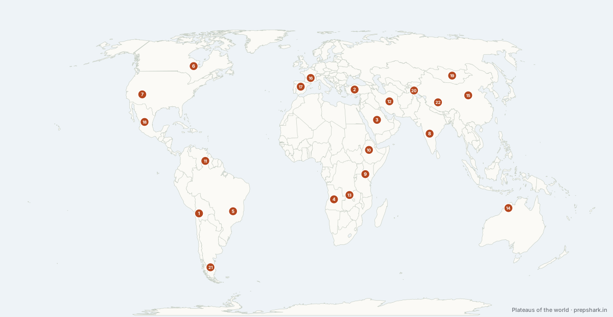
Numbered as on the map
The 22 on the map
1. Altiplano
Bolivia
Known forLake Titicaca, the Uyuni salt flat, and the lithium triangle
The widest part of the Andes and the second highest plateau on earth after Tibet — a closed basin at about 3,750 m between the Cordillera Occidental and Oriental. It has no outlet to the sea, so its water ends in Lake Titicaca or evaporates on the Uyuni salt flat.
Settingintermontane plateau · endorheic · puna
For the examSalar de Uyuni is the largest salt flat in the world and part of the Lithium Triangle with Chile and Argentina — the standing resource-geography stem. Titicaca is the highest large navigable lake.
2. Anatolian Plateau
Türkiye
Known forThe plateau between the Pontic and Taurus ranges
An intermontane plateau squeezed between the Pontic Mountains to the north and the Taurus to the south, and pushed west along the North Anatolian Fault as Arabia drives into Eurasia. That fault produced the February 2023 Kahramanmaraş earthquakes.
Settingintermontane plateau · steppe · semi-arid
For the examIntermontane, like Tibet — squeezed between two ranges rather than uplifted alone. Lake Van and the Konya closed basin are its endorheic lakes.
3. Arabian Plateau
Saudi Arabia
Known forThe tilted block that puts Arabia's oil in the east
The Arabian plate tilts east: high along the Red Sea escarpment in the Hejaz and Asir, sloping down across the Najd to the Gulf. That tilt is why almost all the oil is on the eastern, low side and why the escarpment side gets the only reliable rain.
Settingtilted plateau · desert · escarpment
For the examThe tilt is the answer to why Ghawar and the Gulf fields are on the eastern flank. The Asir highlands catch monsoon-edge rain, which is why Yemen and south-west Saudi Arabia are farmed.
4. Bié Plateau
Angola
Known forThe divide that sends one river to the Atlantic and another into the desert
The high interior of Angola, and one of Africa's great water divides: the Kwanza runs west to the Atlantic, the Cubango becomes the Okavango and dies in the Kalahari, and the Zambezi's headwaters rise on its eastern flank.
Settingshield plateau · miombo · headwater divide
For the examThe Okavango rises here and never reaches the sea — it ends in an inland delta in Botswana. That endorheic ending is what the stem usually turns on.
5. Brazilian Highlands
Brazil
Known forThe cerrado, and the escarpment that blocks the Atlantic coast
An old shield plateau covering much of eastern and southern Brazil, dropping to the Atlantic in a steep escarpment called the Great Escarpment or Serra do Mar. Its northern edge feeds the Amazon's right-bank tributaries; its interior holds the cerrado savanna, now Brazil's main soy and cattle frontier.
Settingshield plateau · cerrado savanna · tropical
For the examThe Great Escarpment is why Brazil's rivers reach the Atlantic in falls and why its coastal cities have almost no hinterland plain.
6. Canadian Shield
Canada
Known forThe scraped Precambrian core of North America
The exposed Precambrian core of North America, scraped to bare rock by the Pleistocene ice sheets and left dimpled with tens of thousands of lakes. It wraps Hudson Bay in a horseshoe and holds Canada's nickel, uranium, gold and much of its hydroelectric capacity.
Settingshield · glaciated · boreal forest
For the examShield, not plateau in the uplift sense — the classic example of a craton stripped by continental glaciation. Sudbury nickel and the Athabasca uranium basin are the named deposits.
7. Colorado Plateau
United States of America
Known forThe Grand Canyon, and the textbook case of antecedent drainage
A block of flat-lying sedimentary rock uplifted about 2 km while staying almost undeformed, so its strata are still horizontal. The Colorado River kept cutting as the block rose, which is what produced the Grand Canyon — the classic textbook case of an antecedent river.
Settingsedimentary plateau · canyon country · semi-arid
For the examAntecedent drainage: the river was there before the uplift and cut down as fast as the land rose. The Indus and Brahmaputra gorges are the Asian examples of the same idea.
8. Deccan Plateau
India
Known forA tilted basalt plateau, and the reason India's peninsular rivers run east
A triangular block of ancient Gondwana crust tilting east, edged by the Western and Eastern Ghats and floored in the north-west by the Deccan Traps — up to 2 km of flood basalt erupted at the Cretaceous–Palaeogene boundary as India crossed the Réunion hotspot. The eastward tilt is why the Godavari, Krishna and Kaveri all run to the Bay of Bengal while only the Narmada and Tapi run west.
Settinglava plateau · black cotton soil · tropical dry
For the examThe Traps are flood basalt, not a volcano. Black regur soil sits on them, which is the link to cotton in Maharashtra.
9. East African Plateau
Kenya
Known forThe plateau the East African Rift splits
A broad upwarp of the African shield, split down the middle by the two branches of the East African Rift. The doming is why the equator here is temperate rather than sweltering, and why Africa's great lakes sit in a ring around it — Victoria in the sag between the two rift arms, Tanganyika and Malawi in the western trough.
Settingshield plateau · rift · savanna
For the examLake Victoria is not a rift lake — it lies in a shallow downwarp between the two rift arms, which is why it is huge but shallow while Tanganyika is narrow and very deep.
10. Ethiopian Highlands
Ethiopia
Known forThe Roof of Africa, and the source of the Blue Nile's flood
A basalt dome split by the East African Rift, and the largest continuous area above 1,500 m in Africa — hence the Roof of Africa. Its summer rains feed the Blue Nile, which supplies most of the Nile's flow and almost all of its silt.
Settingvolcanic plateau · afromontane · rift-split
For the examThe Blue Nile carries roughly 85% of the Nile's water at flood and rises at Lake Tana here — which is why the Grand Ethiopian Renaissance Dam is an Egyptian and Sudanese issue.
11. Guiana Highlands
Venezuela
Known forThe tepuis, and Angel Falls
One of the oldest surfaces on earth — Precambrian sandstone standing as flat-topped tepuis with sheer walls. Angel Falls drops off Auyán-tepui here. The Orinoco's right-bank tributaries drain it, and it holds the Venezuelan Guayana iron and bauxite.
Settingshield plateau · tepui · tropical rainforest
For the examTepui is the landform term — an isolated table mountain. The Essequibo region on its eastern side is the Venezuela–Guyana dispute revived in 2023.
12. Iranian Plateau
Iran
Known forThe dry interior behind the Zagros and Alborz
A high, dry intermontane block rimmed by the Zagros to the west and the Alborz to the north, so moist air is stripped on every side. The interior holds two of the harshest deserts anywhere, the Dasht-e Kavir and the Dasht-e Lut.
Settingintermontane plateau · desert basin · arid
For the examIran's population sits on the plateau rim, not in it — the qanat system is the classic answer for how a rim settlement waters itself off mountain groundwater.
13. Katanga Plateau
Democratic Republic of the Congo
Known forThe Copperbelt — the world's cobalt supply
The southern rim of the Congo basin, and the surface under the Central African Copperbelt. Katanga and the Zambian belt beside it hold roughly 70% of world cobalt output, which is what puts an ore body in a plateau entry: cobalt is the constraint on lithium-ion cathodes and the reason DRC mining terms are a standing item in resource-security papers.
Settingshield plateau · miombo woodland · ore belt
For the examDRC produces the large majority of world cobalt; Chinese firms hold most of the refining. The Lobito Corridor to the Angolan coast, revived in 2023–24, is the alternative to routing it through South Africa.
14. Kimberley Plateau
Australia
Known forAustralia's north-west sandstone country and its extreme tides
A rugged sandstone plateau in Australia's far north-west, cut by deep gorges and fringed by one of the largest tidal ranges on earth in King Sound. It carries the monsoon end of Australia's wet–dry tropics.
Settingsandstone plateau · savanna · monsoon tropics
For the examTides in King Sound reach about 11 m, among the world's largest, which is what produces the horizontal waterfalls at Talbot Bay.
15. Loess Plateau
China
Known forThe silt that makes the Huang He yellow
Up to 300 m of wind-blown silt from the Gobi, piled over millennia and cut into gullies by rain. It is the most erodible large surface on earth, and its silt is what makes the Huang He the Yellow River — and what raised its bed above the surrounding plain behind levees.
Settingaeolian plateau · loess · semi-arid
For the examLoess is aeolian — deposited by wind, not water. The Huang He's suspended load is the highest of any large river, and the raised bed is why it is called China's Sorrow.
16. Massif Central
France
Known forFrance's volcanic watershed
An uplifted Hercynian block with a chain of young volcanic cones on top — the Chaîne des Puys. It is the watershed of France: the Loire, the Allier, the Dordogne and the Lot all rise on it, and it splits Atlantic from Mediterranean drainage.
Settingblock plateau · extinct volcanoes · temperate upland
For the examHercynian (Variscan) block — an old fold mountain worn to a plateau, not a young fold range. The same age class as the Vosges, the Black Forest and the Ural.
17. Meseta Central
Spain
Known forInterior Iberia's dry tableland
The tilted tableland that is most of interior Iberia, rimmed by the Cantabrian, Iberian and Betic ranges and cut in two by the Sistema Central. Rimmed on every side, it is dry and strongly continental for a peninsula — hot summers, cold winters, and the Tagus, Douro and Guadiana draining it west to the Atlantic through Portugal.
Settingblock plateau · continental · semi-arid
For the examThe Tagus, Douro and Guadiana all rise in Spain and reach the sea in Portugal, which is the shared-basin problem behind the Albufeira Convention.
18. Mexican Plateau
Mexico
Known forThe plateau between the two Sierra Madres
An intermontane plateau between the Sierra Madre Occidental and Oriental, tilting up from north to south and closed at its southern end by the Trans-Mexican Volcanic Belt. Mexico City sits in a former lake basin on that southern rim, which is why it floods and subsides at once.
Settingintermontane plateau · semi-arid · volcanic rim
For the examThe Trans-Mexican Volcanic Belt carries Popocatépetl and Paricutín and closes the plateau's southern edge — it is also the divide between Nearctic and Neotropical fauna.
19. Mongolian Plateau
Mongolia
Known forThe Gobi and the steppe, deep in continental Asia
A high, dry interior plateau far from every ocean, so continentality gives it fierce winters and hot summers. It holds the Gobi in the south and the steppe belt in the north, and it is the source region for the dust that reaches Beijing and Korea each spring.
Settingcontinental plateau · steppe · cold desert
For the examContinentality is the mechanism — distance from the sea, not altitude alone. Mongolia's dzud, a summer drought followed by a killing winter, is the recurring livestock disaster.
20. Pamir Knot
Tajikistan
Known forWhere five great ranges meet
The mountain junction where the Himalaya, Karakoram, Hindu Kush, Kunlun and Tian Shan all converge — a high plateau rather than a single range, and the second place called the Roof of the World. The Wakhan Corridor along its southern edge was drawn to keep British India and Russian Central Asia from touching.
Settinghigh plateau · glaciated · cold desert
For the examName the five ranges. The Wakhan Corridor gives Afghanistan a 76 km border with China and is the reason Afghanistan and Pakistan do not have India as a neighbour there.
21. Patagonian Plateau
Argentina
Known forA rain-shadow plateau — cold desert in the Andean lee
A dry, wind-scoured tableland in the lee of the Andes. The westerlies dump their rain on the Chilean side and arrive here already dry, which makes Patagonia a rain-shadow cold desert at a latitude that is otherwise temperate.
Settingrain-shadow plateau · cold desert · steppe
For the examThe standard rain-shadow example in the southern hemisphere. Note that it is dry because the mountains are to its WEST — the mirror of the Thar's position relative to the Aravallis.
22. Tibetan Plateau
China
Known forThe Roof of the World, and the source of ten major Asian rivers
The highest and largest plateau on earth — 2.5 million km² averaging over 4,500 m, raised by the same India–Eurasia collision that built the Himalaya. It is an intermontane plateau: hemmed by the Himalaya to the south, the Kunlun to the north and the Karakoram to the west. Its ice and snow feed the Indus, Sutlej, Brahmaputra, Salween, Mekong, Yangtze and Huang He, which is why it is called the Third Pole and the Water Tower of Asia.
Settingintermontane plateau · cold desert · alpine steppe
For the examIntermontane — the type asked for. It is the source region of the Indus, Sutlej and Brahmaputra, all three of which rise in western Tibet within about 100 km of Mount Kailash and then run in three different directions.
Keep going