Geography · World Atlas
Mountain ranges of the world
The earth's landforms and its ocean, and why each one sits where it does.
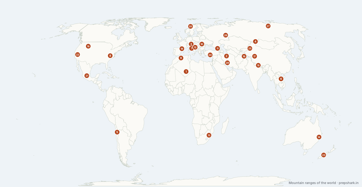
Numbered as on the map
The 28 on the map
1. Ahaggar (Hoggar)
Algeria
Known forVolcanic peaks in the middle of the Sahara
A volcanic massif rising out of the central Sahara to nearly 3,000 m, high enough to be cooler and slightly wetter than the desert around it. Its rock art records a green Sahara of savanna and lakes as recently as 6,000 years ago, before orbital changes shut the monsoon down.
Settingvolcanic massif · Saharan · relict highland
For the examThe African Humid Period is the mechanism: orbital precession moved the monsoon north, greened the Sahara, and then reversed. It is the standard example of orbital forcing on a human timescale.
2. Alborz Mountains
Iran
Known forRice on one slope, desert on the other
A narrow, high range between the Caspian and the Iranian Plateau, carrying Damavand at 5,610 m. It wrings the Caspian's moisture out on its northern slope — which is why Gilan and Mazandaran are rice country while Tehran on the southern side is semi-desert. The contrast across one ridge is the sharpest rain-shadow example in Asia.
Settingfold range · Hyrcanian forest · sharp rain shadow
For the examThe Hyrcanian forests on the Caspian slope are a World Heritage site and a relict of the Ice Ages — the vegetation half of the rain-shadow story.
3. Alps
France / Switzerland / Italy / Austria
Known forEurope's watershed, and its great passes
Raised where Africa collides with Europe. The range is the watershed between the Rhine, the Rhône, the Po and the Danube, and the barrier every north–south route through Europe has to cross by pass or tunnel.
Settingrange · mountain
4. Altai
Russia / Mongolia / Kazakhstan / China
Known forWhere Russia, China, Mongolia and Kazakhstan meet
Where Russia, Mongolia, Kazakhstan and China meet. The watershed here parts rivers draining north to the Arctic from those draining into Central Asia’s closed basins.
Settingrange · mountain
5. Andes
Chile / Argentina / Bolivia / Peru / Ecuador / Colombia
Known forThe reason the Amazon flows east
The longest continental range on earth, 7,000 km down the Pacific edge, and the reason the Amazon flows east.
Settingrange · permanent ice
6. Annamite Range
Laos
Known forThe divide between Indic and Sinic Asia
The range along the Laos–Vietnam border, forming the watershed between the Mekong and the South China Sea and the historic divide between Indic and Sinic South-East Asia. Its remoteness is why several large mammals — the saola among them — were only described by science in the 1990s.
Settingfold range · monsoon rainforest · high endemism
7. Apennines
Italy
Known forItaly's spine, and where its earthquakes happen
The range running the length of the Italian peninsula, raised as the Adriatic microplate collides with Europe. It is still tectonically active in extension, which is why Italy's destructive earthquakes — L'Aquila 2009, Amatrice 2016 — occur along its spine rather than at its edges.
Settingfold range · seismic · Mediterranean
8. Appalachians
United States of America
Known forOlder than the Atlantic that separated it from Scotland
Old, worn and forested — the same orogeny as the Scottish Highlands and the Atlas, before the Atlantic opened.
Settingrange · mountain
9. Atlas
Morocco / Algeria / Tunisia
Known forThe Sahara's northern wall
The wall that keeps the Sahara out of the Maghreb coast.
Settingrange · mountain
10. Carpathians
Slovakia / Poland / Ukraine / Romania
Known forThe arc around the Hungarian plain
A long arc curving around the Pannonian basin, enclosing Transylvania. Europe’s largest remaining tracts of old-growth forest and its densest large-carnivore population are here.
Settingrange · mountain
11. Caucasus
Russia / Georgia / Azerbaijan
Known forThe wall between the Black Sea and the Caspian
The wall between the Black Sea and the Caspian, and the conventional Europe–Asia boundary in the south. Mount Elbrus on its crest is the highest point in Europe.
Settingrange · mountain
12. Dinaric Alps
Croatia
Known forThe limestone that gave karst its name
The range along the eastern Adriatic, and the type region for karst — the word itself comes from the Kras plateau here. Rain sinks straight through the limestone into caves and underground rivers, so the surface is dry and stony while enormous flows run beneath it.
Settingfold range · karst · Mediterranean to alpine
For the examKarst: dolines, poljes, sinking streams and caves in soluble limestone. Every karst landscape in the world is described in terms first defined here.
13. Drakensberg
South Africa / Lesotho
Known forThe eroded edge of the southern African plateau
The eroded edge of the Southern African plateau, a basalt escarpment dropping to the coastal lowland. The Orange and Tugela rivers rise on it.
Settingrange · mountain
14. Great Dividing Range
Australia
Known forIt puts the whole Australian interior in rain shadow
It puts the whole Australian interior in rain shadow.
Settingrange · mountain
15. Himalaya
Nepal / India / China
Known forThe highest range on earth, raised by India colliding with Asia and still rising
The highest range on earth, raised by India colliding with Asia and still rising.
Settingrange · permanent ice
16. Karakoram & Hindu Kush
Pakistan / India / China
Known forThe most heavily glaciated range outside the poles
The most heavily glaciated range outside the poles, raised on the western syntaxis of the India–Asia collision. It carries K2 and four of the fourteen eight-thousanders, and the Siachen glacier along its Indian flank.
Settingrange · permanent ice
17. Kunlun Mountains
China
Known forTibet's northern wall, raised far from any margin
One of the longest ranges in Asia, walling the Tibetan Plateau off from the Tarim Basin for 3,000 km. It is a collision range far from any plate margin, raised by the same India–Asia convergence that built the Himalaya 1,500 km to its south — which is the clearest demonstration that collision deforms a continent's whole interior, not just its edge.
Settingcollision range · cold desert · glaciated
For the examIntraplate deformation is the point: the Kunlun, the Tian Shan and the Altai are all uplifted by a collision happening far away.
18. Pyrenees
Spain / France
Known forThe wall between France and Iberia
The wall between Iberia and the rest of Europe, raised as Iberia rotated into France. It has no easy pass, which is why Iberia stayed culturally distinct.
Settingrange · mountain
19. Rocky Mountains
United States of America / Canada
Known forThe continental divide of North America
The eastern wall of the North American cordillera, and the continental divide runs along it.
Settingrange · mountain
20. Scandinavian Mts
Norway / Sweden
Known forThe spine of the Scandinavian peninsula, worn stubs of an ancient orogeny
The spine of the Scandinavian peninsula, worn stubs of an ancient orogeny. Its western scarp drops straight to the fjords; its gentle eastern slope drains to the Gulf of Bothnia.
Settingrange · mountain
21. Sierra Madre
Mexico
Known forThe two ranges framing the Mexican plateau
The Sierra Madre Occidental and Oriental frame the Mexican plateau east and west, continuing the North American cordillera south. The Occidental hides the Copper Canyon system, deeper than the Grand Canyon.
Settingrange · mountain
22. Sierra Nevada & Cascades
United States of America
Known forThe Sierra Nevada and the Cascades: the western wall of North America
The Sierra Nevada and the Cascades: the western wall of North America. The Sierra’s rain shadow makes the Great Basin a desert; the Cascades carry the arc volcanoes, Rainier to Shasta.
Settingrange · mountain
23. Southern Alps
New Zealand
Known forRaised where two plates grind past each other
Raised along the Alpine Fault where the Pacific and Australian plates grind past each other. The range wrings the rain out of the westerlies, so Westland is temperate rainforest and Canterbury on the lee side is dry plain.
Settingrange · mountain
24. Taurus Mountains
Türkiye
Known forAnatolia's southern wall, and one gate through it
The range along southern Anatolia, raised where the African and Arabian plates push into Eurasia. It walls the Anatolian Plateau off from the Mediterranean, and the Cilician Gates through it are the one practical route between the two.
Settingfold range · limestone karst · Mediterranean
25. Tian Shan
Kyrgyzstan / China
Known forThe wall between the Tarim and Central Asia
A long east–west range walling off the Tarim basin from Central Asia, uplifted far from any plate margin by the same collision that raised the Himalaya. Its meltwater feeds the oasis cities of the old Silk Road.
Settingrange · mountain
26. Urals
Russia
Known forThe conventional boundary between Europe and Asia
The conventional boundary between Europe and Asia, and an old worn range rather than a high one.
Settingrange · mountain
27. Verkhoyansk Range
Russia
Known forThe northern hemisphere's cold pole
An arc of mountains east of the Lena in northern Siberia, enclosing the basins where the coldest temperatures in the northern hemisphere are recorded — Verkhoyansk and Oymyakon, both around −68°C. Cold air pools in the valleys and cannot escape, which is what makes a basin colder than a summit.
Settingfold range · permafrost · extreme continental
For the examTemperature inversion in an enclosed basin is the mechanism. Oymyakon is the coldest permanently inhabited place on earth.
28. Zagros
Iran / Iraq
Known forFolded rock, and the roof over Gulf oil
A fold belt raised where the Arabian plate drives under Iran. Its folds trap much of the Persian Gulf’s oil, and its rain shadow makes the Iranian plateau a desert.
Settingrange · mountain
Keep going