Geography · World Atlas
Seas, gulfs & bays of the world
The earth's landforms and its ocean, and why each one sits where it does.
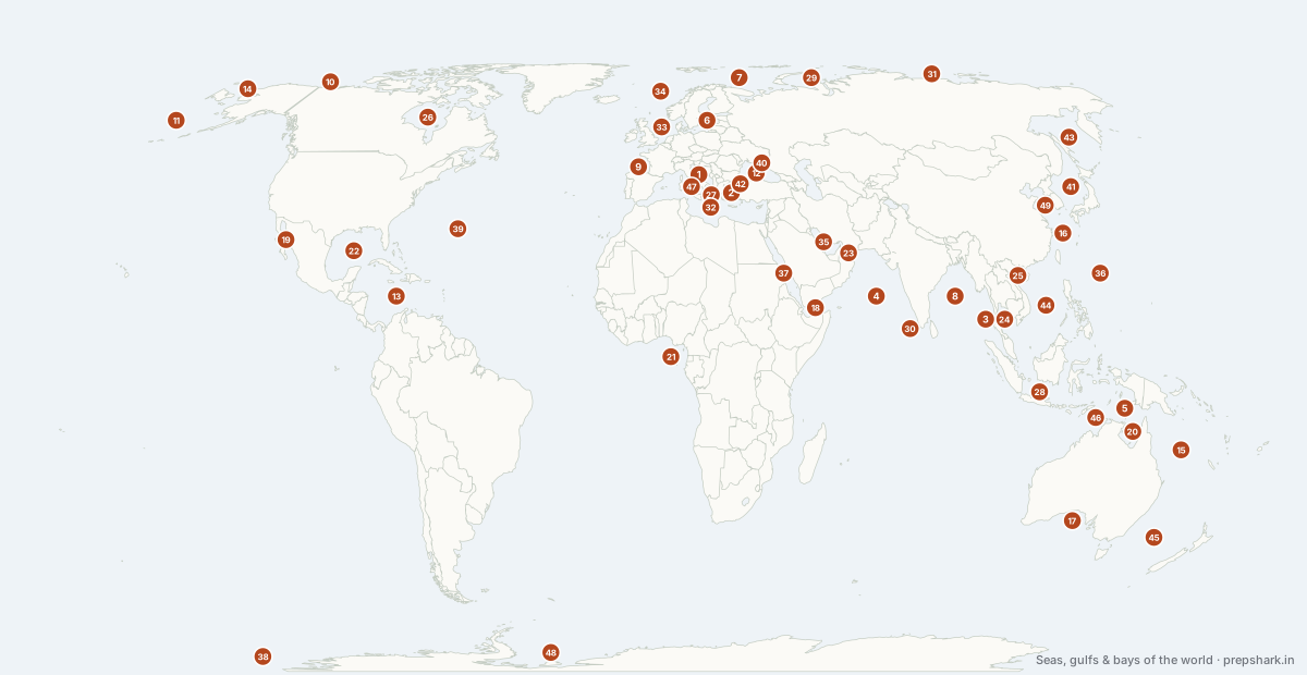
Numbered as on the map
The 49 on the map
1. Adriatic Sea
open sea
Known forThe sea between Italy and the Balkans
The long arm of the Mediterranean between Italy and the Balkans, entered through the Strait of Otranto. Its northern end is shallow and silting, which is why Venice sits in a lagoon and why it floods.
Settingmarginal sea · shallow north · Otranto sill
2. Aegean Sea
open sea
Known forThe contested island sea between Greece and Türkiye
The island-filled arm of the Mediterranean between Greece and Türkiye, formed by a drowned mountain landscape. Its continental shelf, airspace and territorial-sea limits are all contested between the two states, and it is the main sea route for irregular migration into the European Union.
Settingmarginal sea · drowned relief · archipelagic
For the examGreece claims 6 nautical miles of territorial sea here and could claim 12 under UNCLOS; Türkiye has declared that doing so would be a cause for war. Türkiye is not a party to UNCLOS.
3. Andaman Sea
open sea
Known forIndia's eastern sea, and its only volcano
The arm of the Indian Ocean east of the Andaman and Nicobar chain, floored by an active back-arc spreading centre. India's only volcano, Barren Island, stands in it, and the Andaman and Nicobar Command at Port Blair is India's only tri-service command.
Settingback-arc basin · spreading centre · monsoon
For the examBarren Island is India's only active volcano. The chain's southern tip, Indira Point, sits about 150 km from Indonesia and guards the western approach to Malacca.
4. Arabian Sea
open sea
Known forThe monsoon sea, and its reversing currents
The north-western arm of the Indian Ocean, and the one large sea whose surface currents reverse twice a year with the monsoon. Summer monsoon winds drive upwelling off Somalia and Oman, which makes it seasonally one of the most productive seas anywhere — and also gives it a large oxygen minimum zone.
Settingtropical sea · monsoon-reversing · oxygen minimum zone
For the examThe Somali Current reversing with the monsoon is the standard example of a wind-driven current changing direction seasonally. The Arabian Sea's oxygen minimum zone is among the world's thickest.
5. Arafura Sea
open sea
Known forThe drowned floor of Sahul
A shallow sea over the Sahul Shelf between New Guinea and Australia — dry land during ice ages, when the two were one continent called Sahul. It opens south into the Gulf of Carpentaria and west into the Timor Sea.
Settingshelf sea · very shallow · Sahul Shelf
For the examSahul and Sundaland are the paired ice-age landmasses either side of Wallacea — the deep-water gap that neither joined and that biogeography turns on.
6. Baltic Sea
open sea
Known forThe world's largest brackish sea
The largest brackish water body in the world — shallow, nearly enclosed, and fed by so much river water that its surface is barely salty. Its only exit is through the narrow Danish Straits, which is why its deep water renews rarely and its dead zones are the largest in the world.
Settingbrackish sea · shallow · hypoxic deeps
For the examWith Finland joining NATO in 2023 and Sweden in 2024, every Baltic coastal state except Russia is now in NATO. The Nord Stream pipelines were sabotaged on its floor in September 2022.
7. Barents Sea
open sea
Known forThe ice-free Arctic shelf and the Northern Sea Route's western end
A shallow Arctic shelf sea, largely ice-free in the south because of the warm Atlantic inflow, and the western end of the Northern Sea Route. It holds very large gas fields, including Shtokman, and Russia's Northern Fleet is based on its Kola shore.
SettingArctic shelf sea · seasonal ice · gas province
For the examNorway and Russia settled their maritime boundary here in 2010 after forty years. Retreating sea ice is opening the Northern Sea Route, cutting Asia–Europe distance by roughly 40% against Suez.
8. Bay of Bengal
open sea
Known forThe world's largest bay, and its deadliest cyclone coast
The largest bay in the world, and the most dangerous. Enormous river discharge from the Ganga, Brahmaputra and Irrawaddy caps it with fresh water that warms fast, so cyclones intensify quickly; a shallow, funnel-shaped northern coast then piles storm surge onto the most densely populated delta on earth. The Bengal Fan beneath it is the largest submarine fan in the world.
Settingtropical bay · low-salinity cap · Bengal Fan
For the examThe funnel shape plus a shallow shelf plus a low-lying delta is why the Bay produces the world's deadliest storm surges despite the Arabian Sea and Pacific seeing more cyclones. BIMSTEC is the regional grouping named for it.
9. Bay of Biscay
open sea
Known forThe Atlantic's roughest bight
The bight of the Atlantic between France and northern Spain, notorious for heavy seas: Atlantic swell driven by the westerlies runs into a rapidly shallowing continental shelf and steepens.
Settingshelf sea · storm swell · submarine canyons
10. Beaufort Sea
open sea
Known forThe Arctic's freshwater reservoir
The Arctic sea north of Alaska and the Yukon, home of the Beaufort Gyre — a clockwise circulation that stores an enormous volume of fresh water from Siberian rivers and ice melt. A sudden release of that fresh water into the North Atlantic could weaken the overturning circulation.
SettingArctic sea · Beaufort Gyre · freshwater store
For the examCanada and the United States dispute the maritime boundary here, and Canada claims the Northwest Passage through it as internal waters while the US calls it an international strait.
11. Bering Sea
open sea
Known forOne of the world's great fisheries, below the Bering Strait
A large sub-Arctic sea between Alaska and Kamchatka, closed to the south by the Aleutian arc. Its broad shelf is one of the most productive fisheries on earth — roughly half the United States' fish catch by weight — and it narrows north into the Bering Strait.
Settingsub-Arctic sea · broad shelf · upwelling
12. Black Sea
open sea
Known forThe world's largest anoxic basin, behind the Turkish Straits
The largest meromictic body of water on earth: below about 150 m it is permanently anoxic, because heavy salt water from the Mediterranean sits under light river water from the Danube, Dnieper and Don and the two never mix. Its only outlet is the Turkish Straits, which the 1936 Montreux Convention places under Turkish control.
Settingmarginal sea · meromictic · anoxic below 150 m
For the examMontreux gives Türkiye the right to close the Straits to warships in wartime, which it invoked in February 2022. The Black Sea Grain Initiative ran through it from July 2022 until Russia left in July 2023.
13. Caribbean Sea
open sea
Known forThe hurricane sea, and the Gulf Stream's engine room
A deep marginal sea on its own tectonic plate, enclosed by the Greater and Lesser Antilles. Water driven into it by the trade winds squeezes out through the Yucatán Channel to become the Gulf Stream, and its warmth is what feeds Atlantic hurricanes.
Settingmarginal sea · own plate · hurricane belt
For the examThe Lesser Antilles are a volcanic island arc where the Atlantic subducts under the Caribbean Plate — Soufrière and Mont Pelée sit on it.
14. Chukchi Sea
open sea
Known forThe Pacific gateway to the Arctic
The shallow Arctic shelf sea immediately north of the Bering Strait, where warm Pacific water enters the Arctic Ocean. Pacific water flowing north through it carries heat that is one reason the ice edge here retreats faster than almost anywhere.
SettingArctic shelf sea · Pacific inflow · fast ice loss
15. Coral Sea
open sea
Known forThe Great Barrier Reef, and repeated mass bleaching
The sea off north-east Australia holding the Great Barrier Reef, the largest coral structure on earth at 2,300 km. It has suffered mass bleaching in 2016, 2017, 2020, 2022, 2024 and 2025 — the shortening interval is the point, because reefs need about a decade to recover.
Settingtropical sea · barrier reef · warming
For the examThe Great Barrier Reef is the largest structure built by living organisms. Bleaching is coral expelling its symbiotic zooxanthellae under heat stress — the coral is not yet dead when it bleaches.
16. East China Sea
open sea
Known forThe Senkaku dispute and a contested shelf boundary
The shelf sea between China, Taiwan, Japan and Korea, floored by the Yangtze's sediment and edged by the Okinawa Trough. China and Japan dispute both the Senkaku (Diaoyu) Islands in it and where the boundary between their exclusive economic zones runs — China argues for the natural prolongation of its shelf to the Trough, Japan for a median line.
Settingshelf sea · Okinawa Trough · gas fields
For the examChina declared an Air Defence Identification Zone over it in 2013, overlapping Japan's. The shelf-versus-median-line argument is the standard UNCLOS delimitation example.
17. Great Australian Bight
Australia
Known forThe Nullarbor coast, where no river reaches the sea
The open bight along southern Australia, backed by the Nullarbor — the world's largest single slab of limestone, so flat and porous that no river crosses it and the coast ends in the Bunda Cliffs.
Settingopen bight · limestone coast · Southern Ocean swell
For the examNullarbor means no tree. Karst: rain sinks through the limestone rather than running off, so there is no surface drainage at all.
18. Gulf of Aden
open sea
Known forThe approach to Bab-el-Mandeb
The arm of the Indian Ocean between Yemen and Somalia, opening west into Bab-el-Mandeb and the Red Sea. It is a spreading ridge, geologically, and a chokepoint approach, strategically — the focus of anti-piracy operations from 2008 and of attacks on shipping from late 2023.
Settingrift gulf · spreading ridge · chokepoint approach
For the examIndia has kept warships on anti-piracy patrol here since 2008. Djibouti on its shore hosts American, French, Japanese and Chinese bases — the densest concentration of foreign bases anywhere.
19. Gulf of California
Mexico
Known forA rift that has flooded, and the vaquita's last water
A young ocean basin opening as Baja California is torn from the mainland along the San Andreas system — a rift that has already flooded. It is one of the most biologically rich seas in the world, and the vaquita porpoise in its north is the most endangered marine mammal, with a handful of individuals left.
Settingrift basin · high productivity · endemic
For the examIt is a rift valley invaded by the sea — the Red Sea is the same process further along. The Colorado no longer reaches its head in most years.
20. Gulf of Carpentaria
Australia
Known forThe shallow northern gulf, and the Morning Glory cloud
A shallow gulf cut into northern Australia, under 70 m deep throughout and dry land during ice ages. It is famous for the Morning Glory — a roll cloud up to a thousand kilometres long that forms over it in spring.
Settingshallow gulf · monsoon · prawn fishery
21. Gulf of Guinea
open sea
Known forWhere both zeroes meet, and West Africa's oil coast
The great bight of West Africa, where the Equator and the Prime Meridian cross at sea — the origin point of the coordinate system, in open water. It is a major oil province and, since about 2015, the world's worst region for piracy and crew kidnapping.
Settingtropical gulf · upwelling · oil province
For the exam0°N 0°E is here, in the sea — sometimes called Null Island. The Niger Delta and Angola's offshore blocks are the oil, and the Gulf of Guinea has displaced Somalia as the piracy hotspot.
22. Gulf of Mexico
open sea
Known forThe hurricane amplifier and the Mississippi's dead zone
A nearly enclosed ocean basin fed by the Mississippi, whose nutrient load creates the largest recurring dead zone in United States waters each summer. The Loop Current within it is the warm water that intensifies hurricanes before landfall.
Settingocean basin · Loop Current · hypoxic zone
For the examThe Loop Current's deep warm eddies are what turn a tropical storm into a major hurricane in a day. Deepwater Horizon in 2010 is the reference oil spill.
23. Gulf of Oman
open sea
Known forThe deep-water approach to Hormuz
The approach to the Strait of Hormuz from the Arabian Sea, and the deep-water side of the chokepoint. Chabahar in Iran and Duqm in Oman both sit on it, outside Hormuz — which is precisely their strategic value.
Settinggulf · deep · monsoon-influenced
For the examIndia operates Chabahar's Shahid Beheshti terminal under a 2024 long-term agreement; it is India's route to Afghanistan and Central Asia that bypasses Pakistan, and the western end of the International North–South Transport Corridor.
24. Gulf of Thailand
open sea
Known forThe gulf behind the Kra Isthmus
A shallow, warm gulf enclosed by the Malay peninsula and Indochina. The Kra Isthmus at its neck is the narrowest point of the peninsula, and proposals to cut a canal or build a land bridge across it — most recently Thailand's 2023 Land Bridge plan — would offer an alternative to the Strait of Malacca.
Settingshallow gulf · warm · monsoon
For the examThe Kra Canal has been proposed since the 17th century and never built. Any bypass of Malacca matters to China's Malacca Dilemma — its dependence on one strait for energy imports.
25. Gulf of Tonkin
open sea
Known forChina's one negotiated maritime boundary
The shallow gulf between northern Vietnam and Hainan. China and Vietnam delimited it by treaty in 2000 — the only maritime boundary China has ever agreed by negotiation — which makes it the counter-example to the rest of the South China Sea.
Settingshallow gulf · shelf · fishery
For the examThe 2000 delimitation is worth naming because it shows China can settle by treaty; the 1964 Gulf of Tonkin incident is the other reason the name is known.
26. Hudson Bay
Canada
Known forThe bay still rising after the ice sheets
A huge, shallow inland sea over the Canadian Shield, and the place where the last ice sheet was thickest. The crust is still rebounding from that weight at up to a centimetre a year — isostatic rebound — so the bay is slowly getting shallower and the coast is emerging.
Settinginland sea · shallow · isostatic rebound
For the examIsostatic rebound is the mechanism, and this is its clearest large example. Hudson Bay also has the lowest gravity anomaly on earth for the same reason — mass has not fully flowed back.
27. Ionian Sea
open sea
Known forThe deepest water in the Mediterranean
The deepest part of the Mediterranean, reaching 5,267 m in the Calypso Deep off Greece, and the link between the Adriatic and the central basin.
Settingmarginal sea · deep basin · Calypso Deep
28. Java Sea
open sea
Known forThe drowned floor of Sundaland
A shallow sea over the Sunda Shelf between Java, Sumatra and Borneo — dry land during Pleistocene low sea levels, when the three were one landmass called Sundaland. It is bounded on the east by the Wallace Line.
Settingshelf sea · very shallow · Sunda Shelf
For the examSundaland explains why Borneo, Java and Sumatra share Asian mammals while Sulawesi across the Wallace Line does not — the biogeographic point the stem usually wants.
29. Kara Sea
open sea
Known forThe icy middle of the Northern Sea Route
The Arctic shelf sea east of Novaya Zemlya, fed by the Ob and Yenisei. It is the coldest and iciest stretch of the Northern Sea Route, and the Yamal LNG terminal at Sabetta ships through it.
SettingArctic shelf sea · heavy ice · river-fed
30. Laccadive Sea
open sea
Known forIndia's coral sea
The warm, calm water between south-west India, Lakshadweep, the Maldives and Sri Lanka. It is one of the warmest bodies of water in the world and a coral sea, which makes its reefs among the first to bleach when sea temperatures rise.
Settingtropical sea · atoll reefs · very warm
31. Laptev Sea
open sea
Known forWhere Arctic sea ice is made
Called the birthplace of Arctic ice: winter polynyas here freeze enormous volumes of new sea ice, which the Transpolar Drift then carries across the pole toward Greenland. The Lena delta drains into it.
SettingArctic shelf sea · polynya · ice factory
For the examThe Transpolar Drift starts here — the current that carried Nansen's Fram across the Arctic and that now exports Siberian ice to the Atlantic.
32. Mediterranean Sea
open sea
Known forThe sea between three continents
An almost enclosed sea between three continents, connected to the Atlantic only by the 14 km Strait of Gibraltar. Evaporation exceeds river inflow, so Atlantic water flows in at the surface and saltier water flows out beneath — and the whole basin dried out entirely during the Messinian Salinity Crisis about six million years ago.
Settingmarginal sea · high salinity · negative water balance
For the examIts negative water balance is why the exchange at Gibraltar is two-layer. Twenty-one countries border it, and it carries roughly a fifth of world maritime traffic through Gibraltar and Suez.
33. North Sea
open sea
Known forEurope's oil, gas and wind sea
A shallow shelf sea over drowned continental crust, averaging under 100 m. That shallowness made it easy to drill for oil and gas from the 1970s and makes it the world's densest concentration of offshore wind today.
Settingshelf sea · shallow · Dogger Bank
For the examDogger Bank was dry land until about 8,000 years ago — Doggerland — and now carries the world's largest offshore wind project. The Dogger Bank fishery is the classic shallow-shelf fishing ground.
34. Norwegian Sea
open sea
Known forThe ice-free Arctic sea
Deep Atlantic water off Norway, kept ice-free far above the Arctic Circle by the North Atlantic Drift — which is why Narvik and Murmansk beyond it are warm-water ports at latitudes where Canada is frozen solid.
Settingdeep marginal sea · warm current · Arctic margin
For the examThe GIUK gap — Greenland, Iceland, UK — is the naval chokepoint at its southern edge, and it has mattered again since 2022.
35. Persian Gulf
open sea
Known forThe world's oil basin, behind one strait
A shallow, hot, very saline arm of the Indian Ocean holding the largest concentration of oil and gas on earth — including Ghawar, the largest conventional oil field, and North Field/South Pars, the largest gas field, shared by Qatar and Iran. Its only exit is the Strait of Hormuz.
Settingshallow gulf · hypersaline · hydrocarbon province
For the examAbout a fifth of world petroleum consumption passes Hormuz. North Field/South Pars is the largest gas field in the world and is shared, which is why Qatar–Iran relations survive regional splits.
36. Philippine Sea
open sea
Known forThe largest marginal sea, holding the deepest trench
The largest marginal sea on earth, lying over its own tectonic plate east of the Philippines and Taiwan. Its eastern edge is the Izu–Bonin–Mariana arc, and the Mariana Trench — the deepest place in the ocean — runs along it.
Settingmarginal sea · own plate · trench margin
For the examThe Philippine Sea Plate subducts under Eurasia in the west and the Pacific Plate subducts under it in the east — a plate being consumed on one side while consuming on the other.
37. Red Sea
open sea
Known forThe Suez route, and the trade that left it in 2023
A young ocean opening along a spreading ridge between Africa and Arabia, entered from the Indian Ocean through the 29 km Bab-el-Mandeb and from the Mediterranean through the Suez Canal. Roughly 12% of world trade normally passes through it; Houthi attacks on shipping from November 2023 diverted much of that traffic around the Cape of Good Hope, adding around 10 days to Asia–Europe voyages.
Settingrift sea · spreading ridge · hypersaline
For the examIt is a nascent ocean — the Afar triple junction at its southern end is where it meets the Gulf of Aden and the East African Rift. The 2023–24 diversions are the standard chokepoint case study.
38. Ross Sea
open sea
Known forThe largest ice shelf, and the largest marine protected area
The deep bay of the Southern Ocean holding the Ross Ice Shelf, the largest ice shelf in the world at roughly the size of France. In 2016 it became the largest marine protected area on earth, agreed by CCAMLR — the rare case of consensus among states including Russia and China.
Settingpolar sea · ice shelf · marine protected area
For the examThe Ross Ice Shelf is the largest; the MPA agreed in 2016 covers about 1.55 million km² and runs to 2051. Antarctic ice shelves do not raise sea level by melting — they already float — but they buttress the grounded ice that would.
39. Sargasso Sea
open sea
Known forThe sea with no coast
The only sea on earth with no land boundary — it is defined by the four currents of the North Atlantic Gyre that circle it. Its calm, nutrient-poor centre floats mats of Sargassum weed, and it is the spawning ground of both European and American eels.
Settinggyre centre · Sargassum · oligotrophic
For the examBounded by currents, not by land — the fact the stem turns on. The North Atlantic Garbage Patch accumulates in the same gyre centre for the same reason.
40. Sea of Azov
open sea
Known forThe world's shallowest sea, behind the Kerch Strait
The shallowest sea in the world, averaging about 7 m, joined to the Black Sea only by the Kerch Strait. Russia's 2018 bridge across that strait limits the size of ship that can reach the Ukrainian ports of Mariupol and Berdiansk.
Settingmarginal sea · very shallow · brackish
For the examAverage depth about 7 m — the shallowest sea. The Kerch Strait bridge and the Don–Volga canal system make it strategically closed water.
41. Sea of Japan (East Sea)
open sea
Known forThe deep back-arc sea between Japan and Korea
A deep back-arc basin between the Japanese archipelago and the Asian mainland, opened as Japan rifted away about 15 million years ago. Its name is itself disputed: South Korea calls it the East Sea and has pressed for dual naming at the International Hydrographic Organization.
Settingback-arc basin · deep · four narrow straits
For the examIt connects to the open ocean only through four shallow straits — Korea, Tsugaru, Soya and Tatar — so its deep water is isolated and it responds fast to climate change.
42. Sea of Marmara
Türkiye
Known forThe sea between the two Turkish Straits
The small inland sea between the Bosphorus and the Dardanelles, entirely within Turkish territory, and the geographic boundary between Europe and Asia. It sits on the North Anatolian Fault, so a major Istanbul earthquake is expected from beneath it.
Settinginland sea · fault basin · two-layer flow
For the examBosphorus at the north end, Dardanelles at the south — both plus this sea make up the Turkish Straits governed by Montreux.
43. Sea of Okhotsk
open sea
Known forThe lowest-latitude sea that freezes, and Russia's submarine bastion
A cold marginal sea enclosed by Kamchatka, the Kurils and Sakhalin. It is the lowest-latitude sea in the northern hemisphere to freeze over each winter, because the Amur's fresh water floats on top and freezes easily. Russia treats it as a bastion for its ballistic-missile submarines.
Settingcold marginal sea · seasonal ice · Amur-fed
For the examThe Kuril Islands enclosing it are the Northern Territories Japan claims — the reason Russia and Japan have never signed a Second World War peace treaty.
44. South China Sea
open sea
Known forThe world's most contested sea
The most contested water in the world: roughly a third of global shipping crosses it, and China's nine-dash line claims almost all of it against the exclusive economic zones of Vietnam, the Philippines, Malaysia, Brunei and Indonesia. A 2016 arbitral tribunal under UNCLOS found the nine-dash line had no legal basis; China rejects the award.
Settingmarginal sea · reefs and shoals · monsoon-driven
For the examThe 2016 South China Sea Arbitration (Philippines v China) is the case to name. Second Thomas Shoal, where the Philippines grounded the BRP Sierra Madre, has seen repeated water-cannon confrontations since 2023.
45. Tasman Sea
open sea
Known forThe sea over Zealandia
The stretch of Southern Ocean-influenced water between Australia and New Zealand, crossed by the Roaring Forties. Most of the submerged continent of Zealandia lies beneath it.
Settingtemperate sea · westerly storm track · submerged continent
For the examZealandia is a near-continuous piece of continental crust about 94% submerged — recognised as a distinct continent in 2017 and fully mapped in 2023.
46. Timor Sea
open sea
Known forThe gas sea settled by UNCLOS conciliation
The shallow sea between Timor-Leste and northern Australia, holding the Greater Sunrise gas field. The maritime boundary between the two was finally settled in 2018 by the first ever compulsory conciliation under UNCLOS, replacing a treaty widely seen as unfair to Timor-Leste.
Settingshelf sea · gas province · monsoon
For the examThe 2018 Timor Sea Treaty is the only completed compulsory conciliation under UNCLOS Annex V — a named precedent in maritime dispute settlement.
47. Tyrrhenian Sea
open sea
Known forThe volcanic sea inside Italy
The triangle of Mediterranean between mainland Italy, Sardinia and Sicily, floored by a young back-arc basin — which is why Stromboli, Vulcano and the submarine Marsili volcano are in it.
Settingback-arc basin · volcanic islands
48. Weddell Sea
open sea
Known forWhere the world's densest water is made
The Antarctic sea where the densest water on earth is made: sea ice forming on the Filchner–Ronne shelf leaves salt behind, and that cold, salty brine sinks to become Antarctic Bottom Water, which drives the global overturning circulation. Shackleton's Endurance was crushed here in 1915 and found on its floor in 2022.
Settingpolar sea · ice shelf · bottom-water formation
For the examAntarctic Bottom Water is the cold engine of thermohaline circulation. The Filchner–Ronne is the second largest ice shelf after the Ross.
49. Yellow Sea
open sea
Known forThe silt-stained shallow sea between China and Korea
A very shallow shelf sea, mostly under 50 m, named for the Huang He's loess silt that colours it. Its tidal flats are the critical refuelling stop on the East Asian–Australasian Flyway for migratory shorebirds, and reclamation has destroyed most of them.
Settingshelf sea · very shallow · tidal flats
For the examThe Northern Limit Line drawn across it after the Korean War is not recognised by North Korea and is the site of repeated naval clashes.
Keep going