Geography · World Atlas
Rivers of the world
The earth's landforms and its ocean, and why each one sits where it does.
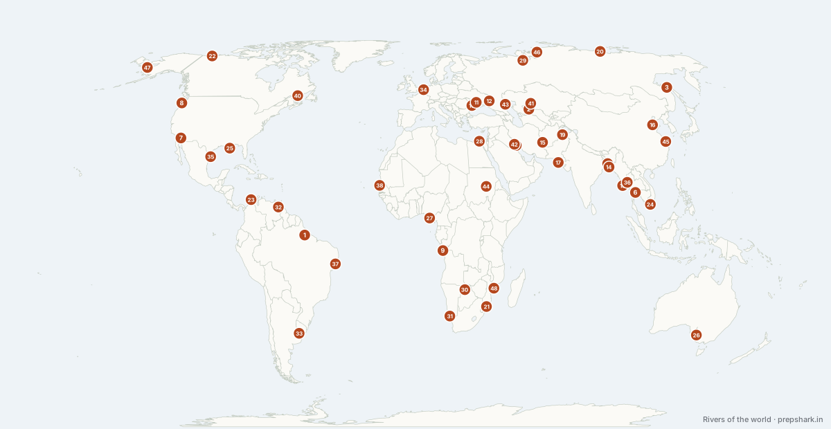
Numbered as on the map
The 48 on the map
1. Amazon
Brazil
Known forA fifth of all river water reaching the sea
The largest river on earth by discharge — about a fifth of all river water reaching the sea — draining the largest rainforest from the Andes to the Atlantic across the Equator.
SettingSouth America · river basin
For the examLongest is contested with the Nile; largest by volume is not contested. At Manaus the dark Rio Negro meets the pale Solímoes — the "meeting of waters".
2. Amu Darya
Uzbekistan
Known forThe Oxus, and the river that killed the Aral
Central Asia's largest river, the classical Oxus, rising in the Pamir and once reaching the Aral Sea. Diversion for cotton took so much that it now often fails to arrive at all. Afghanistan's Qosh Tepa canal, under construction since 2022, would take a further large share upstream — the biggest change to Central Asian water in fifty years.
Settingarid-zone river · fully allocated · terminal
For the examAmu Darya plus Syr Darya equals the Aral's collapse. Afghanistan is not party to the post-Soviet water-sharing arrangements, which is why Qosh Tepa is outside every existing framework.
3. Amur
Russia
Known forThe Russia-China border, and largely undammed
The Russia–China border river for much of its length, and one of the longest undammed rivers in the world.
SettingAsia · river basin
4. Blue Nile
Sudan
Known forThe flood and the silt that made Egypt
Rises at Lake Tana in the Ethiopian Highlands and joins the White Nile at Khartoum. It supplies only about a seventh of the Nile's water in the dry season but roughly 85% at flood, along with almost all the silt — so the Nile's annual flood, and Egyptian agriculture with it, was a Blue Nile event. The Grand Ethiopian Renaissance Dam on it began filling in 2020 and was inaugurated in September 2025.
Settinghighland river · seasonal flood · heavy silt
For the examEgypt argues from the 1929 and 1959 agreements and from prior use; Ethiopia rejects both as colonial-era and asserts equitable utilisation. Talks have failed repeatedly; there is no binding agreement on filling or drought operation.
5. Brahmaputra
Bangladesh
Known forThree names, and the deepest gorge in the world
Runs east across southern Tibet as the Yarlung Tsangpo, turns through the deepest gorge on earth around Namcha Barwa, and floods down through Assam to join the Ganga. The turn is the reason India and China both watch its upstream dams.
SettingAsia · river basin
6. Chao Phraya
Thailand
Known forBangkok's river, on a sinking delta
Thailand's principal river, draining the central plain and carrying Bangkok on its delta. The city is sinking as groundwater is pumped from beneath it, and the combination of subsidence, delta soils and sea-level rise makes it one of the most flood-exposed large cities in the world.
Settingdelta river · rice plain · subsiding
7. Colorado
Mexico
Known forIt cut the Grand Canyon and no longer reaches the sea
It cut the Grand Canyon and no longer reaches the sea in most years — the Colorado delta is dry because the river is fully allocated before it gets there.
SettingNorth America · river basin
8. Columbia
United States of America
Known forNorth America's most dammed river
The most hydroelectrically developed river in North America, rising in Canada and reaching the Pacific through the only sea-level gap in the Cascades. The Columbia River Treaty between Canada and the United States, in force since 1964, reached an agreement in principle on modernised terms in July 2024.
Settingmountain river · heavily dammed · salmon
For the examThe Columbia River Gorge is the only near-sea-level route through the Cascades and is what makes the Pacific North-West's interior reachable.
9. Congo
Democratic Republic of the Congo
Known forIt crosses the Equator twice, so it never runs low
The second largest river by discharge and the deepest in the world, crossing the Equator twice — which is why it flows steadily all year: one hemisphere is always in its wet season.
SettingAfrica · river basin
For the examIt crosses the Equator twice. That double crossing is the reason for its regime, and it is the question.
10. Danube
Romania
Known forTen countries and four capitals
The most international river in the world — ten countries and four capitals — rising in the Black Forest and reaching the Black Sea through a Ramsar delta.
SettingEurope · river basin
For the examFour capitals: Vienna, Bratislava, Budapest, Belgrade. Ten riparian states. The Iron Gate gorge is the Serbia–Romania boundary.
11. Dnipro (Dnieper)
Ukraine
Known forUkraine's dividing river
Europe's fourth longest river, running through Belarus and Ukraine to the Black Sea and dividing Ukraine into right and left banks. The Kakhovka dam across it was destroyed in June 2023, draining the reservoir that supplied cooling water to the Zaporizhzhia nuclear plant and irrigation to Crimea.
Settinglowland river · heavily dammed · steppe
For the examThe North Crimean Canal drew from the Kakhovka reservoir and supplied most of Crimea's water — which is why the reservoir's loss mattered far beyond the dam site.
12. Don
Russia
Known forThe river that connects the Caspian to the ocean
A slow Russian lowland river ending in the Sea of Azov. The Volga–Don Canal joins it to the Volga, giving the Caspian a navigable link to the Black Sea and the world ocean — the reason a landlocked sea has commercial shipping.
Settinglowland river · steppe · canal-linked
13. Euphrates
Iraq
Known forHalf of Mesopotamia, and the upstream half
With the Tigris it makes Mesopotamia — "the land between the rivers" — and the two join above the Persian Gulf as the Shatt al-Arab.
SettingAsia · river basin
For the examBoth rise in Turkey. The Shatt al-Arab is the combined channel, and it is the Iran–Iraq boundary.
14. Ganga
Bangladesh
Known forThe most populous river basin on earth
Drains the southern Himalaya and the north Indian plain, joining the Brahmaputra in Bangladesh to build the largest delta on earth. Its basin is the most populous river basin in the world.
SettingAsia · river basin
15. Helmand
Afghanistan
Known forThe river Iran and Afghanistan argue over
Afghanistan's longest river, rising near Kabul and ending in the Sistan wetlands on the Iranian border rather than in any sea. A 1973 treaty guarantees Iran a share; Afghan dams and drought have repeatedly cut it off, and the dispute turned into a border firefight in May 2023.
Settingendorheic river · desert basin · terminal wetland
For the examEndorheic. The Sistan wetlands (Hamun) are a Ramsar site that has repeatedly dried completely — the environmental half of the dispute.
16. Huang He (Yellow)
China
Known forChina's sorrow, running above its own plain
The "cradle of Chinese civilisation" and "China’s sorrow" — it carries more silt than any river on earth, raising its own bed above the plain until it breaks its levees.
SettingAsia · river basin
For the examIts great northern loop encloses the Ordos. The silt load, not the discharge, is the examinable fact.
17. Indus
Pakistan
Known forAround Nanga Parbat, and the whole length of Pakistan
Rises in Tibet, loops around the western end of the Himalaya through the Nanga Parbat gorge, and runs the length of Pakistan to the Arabian Sea. Its five Punjab tributaries and its allocation between India and Pakistan are fixed by the 1960 Indus Waters Treaty.
SettingAsia · river basin
18. Irrawaddy
Myanmar
Known forMyanmar's spine, and its rice delta
Runs the length of Myanmar from the Kachin hills to a wide delta on the Andaman Sea. The delta is the country’s rice bowl and took the worst of Cyclone Nargis in 2008.
SettingAsia · river basin
19. Kabul River
Pakistan
Known forThe Indus tributary that rises in Afghanistan
Rises west of Kabul and joins the Indus at Attock, so it is the one significant Indus tributary that rises outside India and Pakistan. Afghan plans to dam it — including with Indian support — are watched closely in Pakistan, because the Indus Waters Treaty says nothing about Afghanistan.
Settingmountain river · Indus tributary · transboundary
For the examThe Indus Waters Treaty of 1960 binds only India and Pakistan; Afghanistan and China are both upstream of Indus tributaries and are outside it.
20. Lena
Russia
Known forFrozen half the year, into a delta on the Laptev
The easternmost of the great Siberian rivers, rising near Lake Baikal and running north to a vast delta on the Laptev Sea. It is frozen for over half the year and floods catastrophically on the spring break-up.
SettingAsia · river basin
21. Limpopo
Mozambique
Known forThe border river of southern Africa
Rises in South Africa and runs in a great arc north then east to the Indian Ocean, forming stretches of the South African borders with Botswana and Zimbabwe. It is highly seasonal, and its lower valley in Mozambique floods catastrophically — most severely in 2000.
Settingseasonal river · savanna · flood-prone lower valley
22. Mackenzie
Canada
Known forCanada's longest, into the Beaufort Sea
Canada’s longest river, draining Great Slave Lake north to the Beaufort Sea. Its basin is boreal forest and muskeg, and its delta is one of the largest Arctic wetlands.
SettingNorth America · river basin
23. Magdalena
Colombia
Known forColombia's river between two cordilleras
Colombia's principal river, running north between two arms of the Andes to the Caribbean. It carries one of the highest sediment yields of any river its size because the Andes it drains are young, steep and wet.
SettingAndean river · very high sediment yield · tropical
24. Mekong
Vietnam
Known forSix countries, and a lake that reverses
Six countries from the Tibetan Plateau to the South China Sea, and the Tonle Sap reverses its flow twice a year with the monsoon — the largest such reversal in the world.
SettingAsia · river basin
For the examChina, Myanmar, Laos, Thailand, Cambodia, Vietnam. The Mekong River Commission excludes the two upstream states.
25. Mississippi
United States of America
Known forThe American interior, drained into one bird's-foot delta
With the Missouri it drains the whole American interior between the Rockies and the Appalachians into the Gulf of Mexico, and builds the classic bird’s-foot delta.
SettingNorth America · river basin
For the examThe Mississippi–Missouri system, not the Mississippi alone, is the length that gets quoted. Its delta is bird’s-foot; the Nile’s is arcuate.
26. Murray
Australia
Known forA seventh of Australia, and over-allocated
With the Darling it drains a seventh of Australia, and the basin is the standard case study in over-allocated water.
SettingAustralia & Oceania · river basin
For the examMurray–Darling. The Darling is the longer arm; the Murray carries the water.
27. Niger
Nigeria
Known forA boomerang course that puzzled Europe for centuries
It runs north into the Sahara, turns at Timbuktu and comes back south — a boomerang course that puzzled Europeans for centuries and is explained by two rivers having captured each other.
SettingAfrica · river basin
For the examThe inland delta at Timbuktu, and the oil delta at the mouth. The Benue is the great tributary.
28. Nile
Egypt
Known forTwo branches, one flood, and the whole of Egypt
The longest river in Africa, formed at Khartoum where the White Nile from Lake Victoria meets the Blue Nile from the Ethiopian Highlands. Ninety per cent of Egypt lives on it.
SettingAfrica · river basin
For the examThe Blue Nile carries most of the water and nearly all the silt; the White Nile carries the steady flow. The Aswan High Dam ended the annual flood.
29. Ob
Russia
Known forThe Arctic's longest, across the world's largest swamp
One of three great Siberian rivers flowing north to the Arctic. Because the mouth freezes before the headwaters, spring meltwater has nowhere to go — which is why the West Siberian Plain is the largest wetland on earth.
SettingAsia · river basin
For the examOb, Yenisei, Lena — west to east, all flowing north. The ice-jam flooding is the mechanism to know.
30. Okavango
Botswana
Known forThe river that ends in a desert
Rises on Angola's Bié Plateau and ends in the Kalahari without reaching any sea — the largest inland delta in the world, where the annual flood arrives in the dry season because it takes months to travel down. It is a UNESCO World Heritage site and the reason northern Botswana has wildlife at all.
Settingendorheic river · inland delta · seasonal flood
For the examEndorheic — inland drainage. The flood peak reaches the delta around June, months after the Angolan rains, which inverts the local wet season.
31. Orange
South Africa
Known forIt carried the diamonds to the Atlantic coast
Rises in the Drakensberg and runs west across the whole of South Africa to the Atlantic, forming much of the Namibia border. It carries the diamonds that built Kimberley down to the coast.
SettingAfrica · river basin
32. Orinoco
Venezuela
Known forThe river that leaks into the Amazon
South America's third great river, draining the Guiana Highlands and the llanos. The Casiquiare channel links its headwaters to the Rio Negro and therefore to the Amazon — the largest natural river bifurcation in the world, where one basin drains into two. The Essequibo region on its eastern side is claimed by Venezuela against Guyana, a claim revived by a 2023 referendum after major offshore oil finds.
Settingtropical river · llanos · natural bifurcation
For the examThe Casiquiare bifurcation is the named oddity. The Essequibo dispute is before the International Court of Justice, which ordered Venezuela in December 2023 not to alter the status quo.
33. Paraná
Argentina
Known forItaipu, and the Plata estuary
With the Uruguay it forms the Río de la Plata estuary, and Itaipu on it was the largest dam in the world before the Three Gorges.
SettingSouth America · river basin
For the examThe Plata is an estuary, not a delta. Iguaçu Falls is on the Iguaçu, a tributary, at the triple border.
34. Rhine
Netherlands
Known forEurope's working river, from the Alps to Rotterdam
Rises in the Swiss Alps and runs to a delta shared with the Meuse in the Netherlands. It is Europe’s busiest waterway and, for centuries, the contested border between France and Germany.
SettingEurope · river basin
35. Rio Grande (Río Bravo)
Mexico
Known forThe border river under a treaty drought has broken
Rises in the Colorado Rockies and forms 2,000 km of the United States–Mexico border. A 1944 treaty obliges Mexico to deliver water from its tributaries and the United States to deliver from the Colorado; drought has made the Mexican deliveries repeatedly impossible, and the shortfall is a standing bilateral dispute.
Settingarid-zone river · fully allocated · border
For the examThe 1944 Water Treaty and the International Boundary and Water Commission are the named instruments. The river frequently fails to reach the Gulf.
36. Salween
Myanmar
Known forNearly undammed, through the parallel gorges of Yunnan
Runs nearly free of dams from the Tibetan plateau through deep parallel gorges in Yunnan, then along the Thailand–Myanmar border to the Andaman Sea. The gorges it shares with the Mekong and Yangtze are a World Heritage site.
SettingAsia · river basin
37. São Francisco
Brazil
Known forThe river that waters Brazil's dry north-east
The longest river entirely within Brazil, running north through the dry sertão before turning east to the Atlantic. It is the only large perennial river in Brazil's semi-arid north-east, which is why the São Francisco transposition project diverting it to four other states has been the country's most contested water scheme.
Settingtropical river · semi-arid basin · transposed
38. Senegal River
Senegal
Known forAfrica's model of shared river management
Rises in the Fouta Djallon highlands of Guinea and forms the Senegal–Mauritania border before reaching the Atlantic. Its basin authority, the OMVS, is one of the few genuinely joint river institutions in Africa, with dams owned in common by four states.
SettingSahelian river · seasonal flood · jointly managed
For the examThe OMVS is the standard positive example in transboundary water governance, against the Nile and the Indus as contested ones.
39. Shatt al-Arab
Iraq
Known forThe joined Tigris and Euphrates, and a border that started a war
The 200 km channel formed where the Tigris and Euphrates join, running to the Persian Gulf and forming part of the Iran–Iraq border. Which line in the channel is the border — the low-water mark or the thalweg — was the stated cause of the 1980 Iran–Iraq war.
Settingconfluence channel · marshland · saline intrusion
For the examThalweg means the deepest channel; the 1975 Algiers Accord set the boundary there and Iraq repudiated it in 1980. Upstream damming has cut flow so far that sea water now intrudes into Basra's supply.
40. St Lawrence
Canada
Known forThe outlet for a fifth of the world's fresh surface water
Drains the Great Lakes to the Atlantic, the outlet for a fifth of the world’s fresh surface water. The Seaway locks let ocean ships reach Chicago and Duluth.
SettingNorth America · river basin
41. Syr Darya
Kazakhstan
Known forThe Jaxartes, and the half of the Aral that came back
The longer of Central Asia's two great rivers, the classical Jaxartes, rising in the Tian Shan. Kazakhstan's Kok-Aral dam of 2005 trapped its flow and partially refilled the North Aral Sea — the one place the Aral disaster has been reversed.
Settingarid-zone river · fully allocated · partially restored
For the examThe Kok-Aral dam raised the North Aral's level and brought back a fishery. The South Aral, fed by the Amu Darya, has not recovered.
42. Tigris
Iraq
Known forThe faster of the two rivers of Mesopotamia
Rises in the Turkish highlands and runs down the eastern edge of Mesopotamia, joining the Euphrates above the Persian Gulf. The land between the two rivers is where the first cities were built.
SettingAsia · river basin
43. Volga
Russia
Known forEurope's longest, and it reaches no ocean
The longest river in Europe, and it reaches no ocean — it ends in the Caspian, the largest inland drainage basin on earth.
SettingEurope · river basin
For the examInland drainage. Europe’s longest, and it is not Atlantic-draining.
44. White Nile
Sudan
Known forThe steady branch, halved by the Sudd
The longer of the Nile's two branches, running from Lake Victoria through Uganda and the vast Sudd wetland in South Sudan. The Sudd evaporates roughly half the flow that enters it, which is why the White Nile arrives at Khartoum steady but small — and why the abandoned Jonglei Canal was meant to bypass it.
Settingequatorial river · swamp-regulated · low silt
For the examThe Sudd is the mechanism: a swamp regulates flow and destroys volume. The Jonglei Canal was abandoned in 1983 and its revival is periodically raised.
45. Yangtze
China
Known forAsia's longest, and the Three Gorges
The longest river in Asia and the third longest on earth, rising on the Tibetan Plateau and cutting the Three Gorges before crossing the plain to Shanghai.
SettingAsia · river basin
For the examThe Three Gorges Dam is the largest power station in the world by capacity. The river divides China into north and south for the rice–wheat line.
46. Yenisei
Russia
Known forThe greatest flow into the Arctic Ocean
The largest river by discharge draining into the Arctic Ocean, running due north from the Mongolian border across the whole of Siberia. It parts the flat West Siberian Plain from the Central Siberian Plateau.
SettingAsia · river basin
47. Yukon
United States of America
Known forThe sub-Arctic river thawing out of permafrost
Runs from British Columbia across the Yukon and Alaska to the Bering Sea, frozen for much of the year. Its basin is largely permafrost, and thawing ground is releasing long-buried carbon and turning some tributaries orange with iron and acid released from newly exposed minerals.
Settingsub-Arctic river · permafrost basin · seasonal ice
48. Zambezi
Mozambique
Known forVictoria Falls, and Africa's great east-flowing river
Africa’s largest east-flowing river, and Victoria Falls on it is the largest sheet of falling water on earth.
SettingAfrica · river basin
For the examVictoria Falls is on the Zambia–Zimbabwe border. Kariba and Cahora Bassa are the two great dams.
Keep going