Geography · World Atlas
Straits & channels of the world
The earth's landforms and its ocean, and why each one sits where it does.
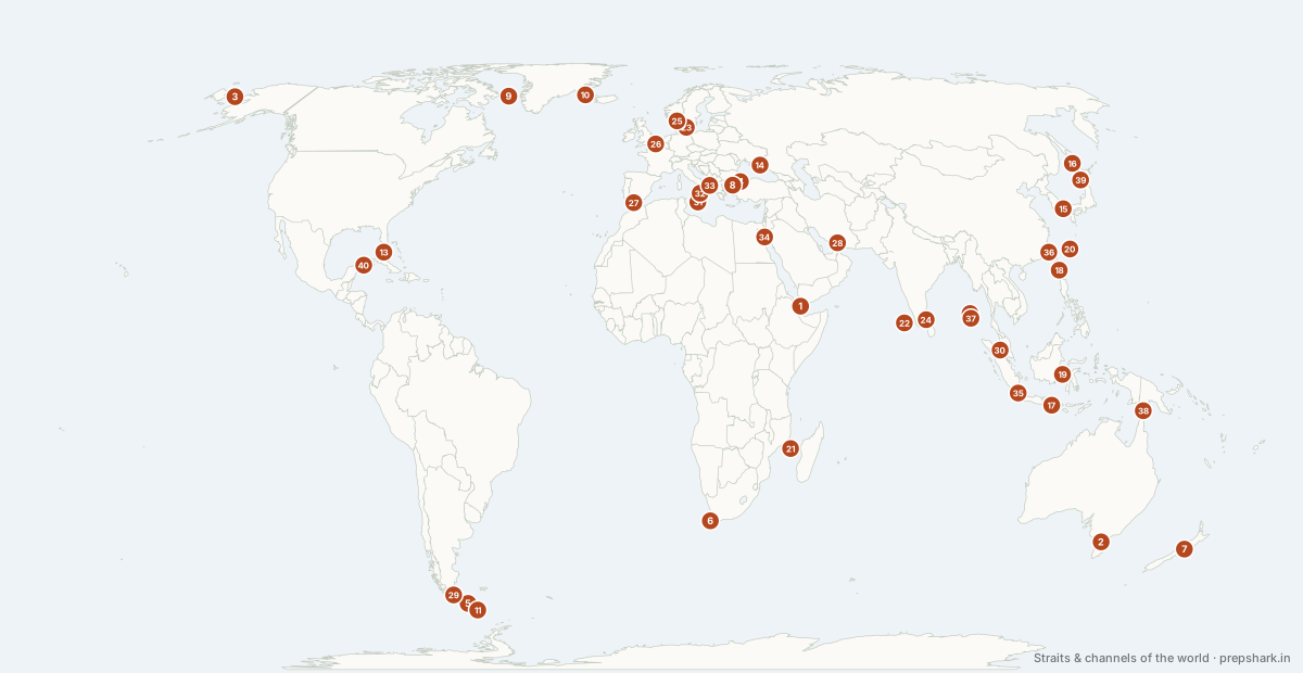
Numbered as on the map
The 40 on the map
1. Bab-el-Mandeb
Red Sea
Known forThe Red Sea's southern gate
The southern gate of the Red Sea, and therefore of the Suez route. Perim island splits it into two channels.
SettingRed Sea → Gulf of Aden
For the examThe pair to remember is Suez at the north end and Bab-el-Mandeb at the south. Closing either closes the route.
2. Bass Strait
Australia
Known forThe drowned land bridge to Tasmania
The 240 km shallow strait between Australia and Tasmania, dry land during ice ages when the two were joined. It carries major gas fields and, being shallow and open to the Southern Ocean swell, is notoriously rough.
Settingshelf strait · shallow · gas province
3. Bering Strait
Pacific Ocean
Known forTwo continents, two hemispheres, two dates
Eighty-two kilometres between two continents and two hemispheres, and the International Date Line runs through it — so the two Diomede islands are a day apart.
SettingPacific Ocean → Arctic Ocean
For the examIt separates Asia from North America and is crossed by the Date Line and the Arctic Circle.
4. Bosphorus
Black Sea
Known forIstanbul, and the first lock on the Black Sea
One of two Turkish Straits, and the only outlet for the Black Sea. It divides a continent through the middle of a city.
SettingBlack Sea → Sea of Marmara
For the examThe sequence north to south is Bosphorus → Sea of Marmara → Dardanelles → Aegean. The Montreux Convention governs passage.
5. Cape Horn
Atlantic Ocean
Known forWhere the Andes end and the Drake Passage begins
The southernmost headland of South America, and the reason the Drake Passage is feared.
SettingAtlantic Ocean → Pacific Ocean
For the examChilean. The Strait of Magellan is the inshore alternative to rounding it.
6. Cape of Good Hope
Atlantic Ocean
Known forNot Africa's southern tip, but where two currents meet
Not Africa’s southernmost point — that is Cape Agulhas, 150 km east — but the corner where the cold Benguela meets the warm Agulhas.
SettingAtlantic Ocean → Indian Ocean
For the examCape Agulhas is the southern tip; Good Hope is the famous one. Questions rely on the confusion.
7. Cook Strait
New Zealand
Known forThe Roaring Forties, funnelled to 22 km
The 22 km channel between New Zealand's two islands, funnelling the Roaring Forties into some of the roughest and most consistently windy water anywhere — which is also why the strait carries the country's inter-island power cable.
Settingstrait · 22 km · extreme winds
8. Dardanelles
Sea of Marmara
Known forThe Hellespont, and the second lock
The southern Turkish Strait, ancient Hellespont, and the second lock on the Black Sea’s only door.
SettingSea of Marmara → Aegean Sea
For the examAsked as a sequence with the Bosphorus. Getting the order backwards is the standard error.
9. Davis Strait
Canada
Known forThe Arctic's outflow to the Labrador Sea
The 340 km passage between Baffin Island and Greenland, joining Baffin Bay to the Labrador Sea. Its sill controls how much cold Arctic water reaches the North Atlantic, which makes it a monitoring point for the overturning circulation.
SettingArctic strait · sill · seasonal ice
10. Denmark Strait
open sea
Known forThe world's largest waterfall, underwater
The 290 km gap between Greenland and Iceland, holding the largest waterfall on earth — an underwater one. Dense Arctic water pours over a sill and falls about 3,500 m, carrying a flow many times that of any river. It is also the western leg of the GIUK gap.
Settingridge strait · cataract of dense water · sill
For the examThe Denmark Strait cataract is a component of Atlantic overturning circulation, and it is a waterfall by volume that no surface fall approaches.
11. Drake Passage
Atlantic Ocean
Known forThe one latitude where no land stops the ocean
The only latitude band where no land obstructs the ocean, which is what lets the Antarctic Circumpolar Current circle the planet and keeps Antarctica cold.
SettingAtlantic Ocean → Pacific Ocean
For the examThe roughest water on earth, and the reason the Southern Ocean has its own name.
12. Duncan Passage
India
Known forThe Andamans' own internal passage
The 48 km channel between South Andaman and Little Andaman, one of the internal passages through India's Andaman chain. The chain's passages — Duncan, the Ten Degree and the Great Channel — are what let shipping cross between the Bay of Bengal and the Andaman Sea without rounding the whole archipelago.
Settingisland passage · 48 km · coral fringed
For the examName the chain's channels in order north to south: Coco Channel, Duncan Passage, Ten Degree Channel, Sombrero Channel, Great Channel. The Great Channel separates Great Nicobar from Sumatra.
13. Florida Strait
United States of America
Known forWhere the Gulf Stream is born
The 150 km channel between Florida, Cuba and the Bahamas, through which the whole Gulf of Mexico's outflow squeezes to become the Gulf Stream. The current runs so hard and so consistently that Spanish treasure fleets used it as a conveyor home.
Settingstrait · 150 km · very strong current
14. Kerch Strait
Ukraine
Known forThe only door into the Sea of Azov
The 4 km strait between the Black Sea and the Sea of Azov, and the only way into Azov. Russia opened a road and rail bridge across it in 2018, whose height limits the size of ship that can reach the Ukrainian Azov ports; the bridge was damaged by attack in 2022 and again in 2023.
Settingstrait · 4 km · very shallow
For the examIts closure was the subject of proceedings brought by Ukraine under UNCLOS. It is the clearest recent example of a bridge functioning as a blockade.
15. Korea Strait
East China Sea
Known forWhere the Kuroshio's warm branch enters the Sea of Japan
The warm Tsushima branch of the Kuroshio enters the Sea of Japan through it, which is why northern Japan’s west coast has such heavy snow.
SettingEast China Sea → Sea of Japan
For the examThe Tsushima Current is the branch, and the Tsushima islands split the strait.
16. La Pérouse (Sōya) Strait
Japan
Known forThe northern exit from the Sea of Japan
The 40 km channel between Hokkaido and Sakhalin, connecting the Sea of Okhotsk to the Sea of Japan. It is the northernmost of the exits from the Sea of Japan and freezes partially in winter.
Settingarc strait · 40 km · seasonal ice
17. Lombok Strait
Java Sea
Known forDeep enough for anything, and the Wallace Line runs in it
Deep enough for any vessel, and it carries the Wallace Line — the biogeographic boundary between Asian and Australasian fauna.
SettingJava Sea → Indian Ocean
For the examThe Wallace Line runs through it. That is why Bali has tigers in its history and Lombok does not.
18. Luzon Strait
Philippines
Known forThe Pacific's deep door into the South China Sea
The 250 km gap between Taiwan and Luzon, and the main deep-water connection between the Pacific and the South China Sea. It is the principal route for submarine transit into that sea, and the Bashi Channel within it carries a large share of the region's undersea internet cables.
Settingdeep strait · 250 km · cable corridor
For the examCable chokepoints matter as much as shipping ones: the 2006 Hengchun earthquake near it severed multiple cables and disrupted internet across East Asia.
19. Makassar Strait
Indonesia
Known forThe Wallace Line, and the Pacific's route to the Indian Ocean
The deep channel between Borneo and Sulawesi, carrying most of the Indonesian Throughflow — the only place where water passes directly from the Pacific to the Indian Ocean at low latitudes. The Wallace Line runs down it, because that deep water was never bridged even at the lowest ice-age sea levels.
Settingdeep strait · Indonesian Throughflow · biogeographic divide
For the examThe Indonesian Throughflow is a component of global circulation. The Wallace Line separates Asian from Australasian fauna, and depth is why.
20. Miyako Strait
Japan
Known forThe gap in the first island chain
The 250 km gap in the Ryukyu chain between Okinawa and Miyako — wide enough that a corridor through the middle is international water, and therefore the main route for Chinese naval and air movement from the East China Sea into the Pacific. Transits through it are reported almost weekly.
Settingarc strait · 250 km · deep
For the examThe first island chain is a barrier only where the gaps are narrow. Miyako is the widest, which is why it carries the traffic and why Japan has been deploying missiles on the islands beside it.
21. Mozambique Channel
Indian Ocean
Known forBetween Madagascar and Africa, and the tanker route
Four hundred kilometres wide and the route round southern Africa for the largest tankers. The warm Agulhas Current forms in it.
SettingIndian Ocean, both ends
For the examThe Agulhas — the strongest western boundary current in the southern hemisphere — begins here.
22. Nine Degree Channel
Arabian Sea
Known forMinicoy on one side, the rest of Lakshadweep on the other
Separates the main Lakshadweep group from Minicoy, which is closer to the Maldives than to the rest of the archipelago.
SettingArabian Sea → Laccadive Sea
For the examPaired with the Eight Degree Channel, which separates Minicoy from the Maldives.
23. Øresund
Denmark
Known forThe Baltic's door, and a bridge into a tunnel
One of the three Danish Straits joining the Baltic to the North Sea, between Copenhagen and Malmö. The Øresund bridge-and-tunnel of 2000 made the crossing a commuter route and created a single cross-border labour market.
Settingstrait · 4 km at its narrowest · brackish
For the examThe Danish Straits — Øresund, Great Belt, Little Belt — are the only natural outlet from the Baltic, which is why the Kiel Canal was cut.
24. Palk Strait
Bay of Bengal
Known forToo shallow to sail, which is the whole argument
Too shallow for large ships, which is why vessels round Sri Lanka instead — the argument for the Sethusamudram project. Adam’s Bridge (Ram Setu) is the shoal chain across it.
SettingBay of Bengal → Gulf of Mannar
For the examPalk Strait to the north, Gulf of Mannar to the south, Adam’s Bridge between. Pamban and Rameswaram sit on the Indian side.
25. Skagerrak & Kattegat
Denmark
Known forHow the Baltic breathes, slowly
The wide arms between Jutland, Norway and Sweden through which the Baltic's brackish surface water leaves and North Sea salt water enters beneath. The exchange is the Baltic's only ventilation, which is why it is so slow and its deeps so oxygen-poor.
Settingstrait system · two-layer exchange · brackish
26. Strait of Dover
English Channel
Known forThe busiest shipping lane in the world
Thirty-three kilometres, the busiest shipping lane in the world by vessel count, and the Channel Tunnel runs beneath it.
SettingEnglish Channel → North Sea
For the examAlso called the Pas de Calais.
27. Strait of Gibraltar
Atlantic Ocean
Known forFourteen kilometres, and the Mediterranean's only door
Fourteen kilometres wide, and the only natural connection between the Atlantic and the Mediterranean — which is why the Mediterranean is saltier and why its deep water is renewed so slowly.
SettingAtlantic Ocean → Mediterranean Sea
For the examThe Pillars of Hercules: Gibraltar on the European side, Jebel Musa on the African.
28. Strait of Hormuz
Persian Gulf
Known forA fifth of the world's petroleum, through one exit
The only sea exit from the Persian Gulf, and about a fifth of the world’s petroleum passes through it. The Musandam peninsula on the southern side is an exclave of Oman, not the UAE.
SettingPersian Gulf → Gulf of Oman
For the examIran on the north, Oman on the south. The island of Hormuz and the disputed Abu Musa and Tunbs sit inside it.
29. Strait of Magellan
Atlantic Ocean
Known forThe sheltered way round the continent
The sheltered route round the continent, used in preference to Cape Horn until the Panama Canal opened.
SettingAtlantic Ocean → Pacific Ocean
For the examEntirely within Chile. Distinguish it from the Drake Passage, which is open ocean south of Cape Horn.
30. Strait of Malacca
Andaman Sea
Known forA quarter of all traded goods, through one strait
The shortest sea route between the Indian and Pacific oceans, and the busiest — roughly a quarter of all traded goods and most of East Asia’s oil pass through a channel 2.8 km wide at its narrowest.
SettingAndaman Sea → South China Sea
For the examThe "Malacca dilemma" is China’s strategic exposure here. Compare with the Sunda and Lombok straits, which are the alternatives.
31. Strait of Malta
Western Mediterranean
Known forWith the Strait of Sicily it is the waist of the Mediterranean, dividing its two basins
With the Strait of Sicily it is the waist of the Mediterranean, dividing its two basins.
SettingWestern Mediterranean → Eastern Mediterranean
For the examThe Sicily Channel is the wider passage; both control movement between the basins.
32. Strait of Messina
Italy
Known forThree kilometres, and a bridge argued over since Rome
The 3 km channel between Sicily and mainland Italy, with strong opposed tidal currents and whirlpools — the Scylla and Charybdis of the Odyssey. A bridge across it has been proposed since Roman times and was revived again in 2023.
Settingstrait · 3 km · strong tidal currents
33. Strait of Otranto
Italy
Known forThe Adriatic's only door
The 72 km entrance to the Adriatic between Italy and Albania, with a shallow sill that restricts deep-water exchange — which is why the Adriatic has its own distinctive dense bottom water.
Settingstrait · 72 km · sill
34. Strait of Tiran
Egypt
Known forThe closure that started a war
The narrow entrance to the Gulf of Aqaba, and therefore the only sea access to the Israeli port of Eilat and the Jordanian port of Aqaba. Egypt's closure of it in May 1967 was the immediate trigger of the Six-Day War; the islands commanding it were transferred to Saudi Arabia in 2017.
Settingstrait · 13 km · coral reefs
For the examThe standard case for the law of international straits and the right of transit passage. Freedom of navigation through it is written into the 1979 Egypt–Israel peace treaty.
35. Sunda Strait
Java Sea
Known forThe deep alternative to Malacca, with Krakatoa in it
The alternative to Malacca for the largest ships, and Krakatoa stands in the middle of it.
SettingJava Sea → Indian Ocean
For the examThe Malacca alternatives are Sunda and Lombok. Both are deeper and both are longer.
36. Taiwan Strait
East China Sea
Known forA hundred and thirty kilometres at its narrowest
A hundred and thirty kilometres at its narrowest, and the Tropic of Cancer crosses Taiwan just south of it.
SettingEast China Sea → South China Sea
For the examAlso the Formosa Strait. The Penghu islands sit inside it.
37. Ten Degree Channel
Bay of Bengal
Known forThe 10 degrees N line, between Andamans and Nicobars
The 10°N parallel separates the Andamans from the Nicobars, and the channel takes its name from the line.
SettingBay of Bengal → Andaman Sea
For the examTen Degree Channel: Andaman | Nicobar. Nine Degree Channel: Lakshadweep | Minicoy. Eight Degree: Minicoy | Maldives. That ladder is the question.
38. Torres Strait
Australia
Known forWhere Australia and New Guinea were joined
The shallow 150 km channel between Cape York and New Guinea, dotted with islands and reefs. It was dry land as recently as 8,000 years ago, joining Australia and New Guinea as the continent of Sahul. Its islanders brought the first climate-change human rights complaint decided against a state, at the UN Human Rights Committee in 2022.
Settingshelf strait · very shallow · reef-strewn
For the examSahul is the ice-age continent. The Torres Strait Islanders' 2022 complaint found Australia had violated their rights by failing to adapt — a precedent in climate litigation.
39. Tsugaru Strait
Japan
Known forA strait Japan chose not to close
The 20 km channel between Honshu and Hokkaido, crossed beneath by the Seikan Tunnel. Japan deliberately limits its territorial sea here to three nautical miles rather than twelve, leaving an international corridor through the middle — which allows nuclear-armed vessels to pass without Japan having to acknowledge them.
Settingarc strait · 20 km · deep and fast
For the examThe three-mile limit is deliberate policy, not an oversight: it keeps the strait an international one. Blakiston's Line, the faunal boundary between Japanese species, runs along it.
40. Yucatán Channel
Mexico
Known forThe channel that feeds the Loop Current
The 217 km gap between the Yucatán peninsula and Cuba, through which Caribbean water enters the Gulf of Mexico and forms the Loop Current — the deep warm eddy that turns tropical storms into major hurricanes.
Settingstrait · 217 km · warm inflow
Keep going